
Happy Monday, everybody!
Thanks for checking in this morning. If you’ve been following the forecast over the last several days, today is the day we’ve been talking about.
A surge of tropical moisture has moved into the Tennessee Valley, and that moisture, combined with multiple disturbances in the atmosphere, is setting the stage for periods of heavy rainfall, tropical-like downpours, and localized flooding concerns across East Tennessee.
Not everyone will see flooding. Not everyone will see the same amount of rain. But wherever thunderstorms repeatedly move across the same area, rainfall rates could become intense enough to create flooding and flash flooding issues.
Let’s break down everything you need to know.
Tropical Moisture Flooding Into East Tennessee
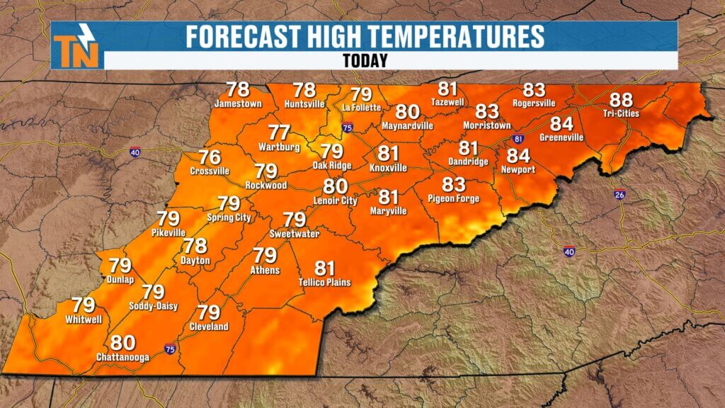
Yesterday’s temperatures climbed into the upper 70s and middle 80s across much of the region, and despite all the rain chances, we’re actually going to continue trending warmer as the week progresses.
The reason?
An abundance of tropical moisture is streaming northward into the southeastern United States.
When you look at the larger weather pattern, moisture is flowing from the Gulf Coast northward through the Tennessee Valley, Mid-Atlantic, Ohio Valley, and Great Lakes region.
This is the type of setup that can produce extremely efficient rainfall rates.
The atmosphere is loaded with moisture, and any thunderstorm that develops will have the ability to dump a tremendous amount of rain in a short period of time.
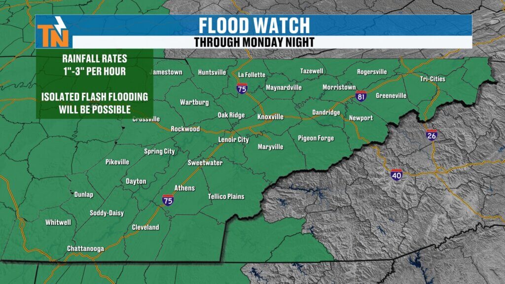
Flood Watch and Flash Flood Concerns
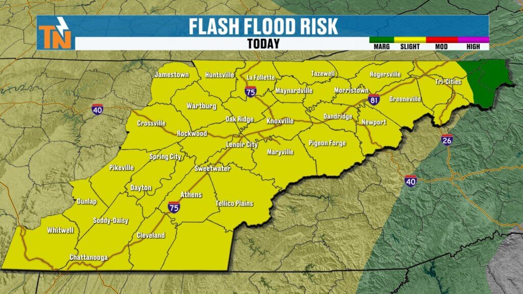
Because of this setup, the National Weather Service has issued a Flood Watch for portions of the region.
In addition, the Weather Prediction Center has placed much of East Tennessee under a Level 2 risk for excessive rainfall and flash flooding.
That means:
- Rainfall rates could exceed 1 to 3 inches per hour
- Localized flooding is possible
- Flash flooding may develop in isolated areas
- Poor drainage locations could experience water issues
- Urban flooding concerns increase during heavier downpours
It’s important to remember that this is not expected to be a widespread flooding event.
Instead, the threat will be highly localized. One neighborhood may receive very little rain, while another community just a few miles away could experience several inches in a short amount of time.
A Tropical Feel Starts the Week
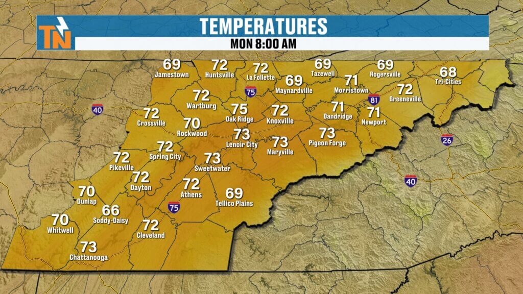
You can certainly feel the change when you step outside this morning.
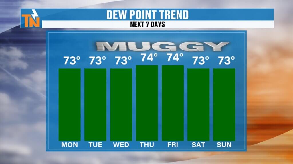
Temperatures are running 5 to 10 degrees warmer than yesterday morning, and humidity levels have increased dramatically.
Most communities are starting the day with:
- Temperatures in the 60s and lower 70s
- Dew points in the upper 60s and lower 70s
- A distinctly tropical feel to the air
It’s one of those classic summer mornings where the humidity hits you immediately when you walk outside.
And this is only the beginning.
The tropical air mass remains in place all week long.
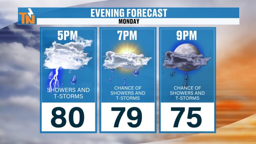
Monday Forecast: Heavy Rain Develops This Afternoon
The morning hours will feature scattered showers moving from southwest to northeast across the region.
Rain coverage becomes more widespread as we approach lunchtime, but the greatest concern arrives during the afternoon and evening hours.
As daytime heating combines with abundant moisture and atmospheric instability, thunderstorms will become increasingly efficient rain producers.
By mid-afternoon:
- Scattered thunderstorms develop
- Rainfall rates intensify
- Visibility may become severely reduced
- Localized flooding becomes possible
- Travel conditions may deteriorate rapidly
These storms will move slowly, allowing rainfall to accumulate quickly.
If you find yourself driving through one of these heavier storms, expect conditions similar to a tropical downpour where visibility becomes extremely limited and water begins accumulating on roadways.
Why Flooding Is a Bigger Concern Than Severe Weather
Unlike traditional severe weather outbreaks, today’s primary threat is water.
The atmosphere contains tremendous amounts of moisture, allowing storms to produce excessive rainfall rather than widespread damaging winds.
Some locations may experience:
- Ponding of water on roads
- Overflowing drainage ditches
- Flooded low-lying areas
- Water-covered roadways
- Isolated flash flooding
The greatest concern develops where multiple storms track over the same location throughout the afternoon and evening.
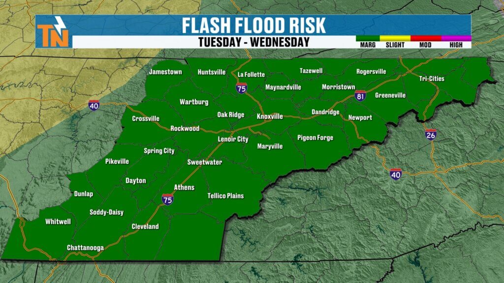
Tuesday Brings More Heavy Rain
Unfortunately, the active pattern doesn’t end today.
A stalled boundary will linger near the region while another upper-level disturbance approaches from the west-northwest on Tuesday.
That setup will continue producing:
- Scattered to numerous thunderstorms
- Additional tropical downpours
- Localized flooding concerns
- Flash flooding potential
While today’s flooding risk is higher overall, Tuesday remains an active weather day with additional rounds of heavy rainfall possible.
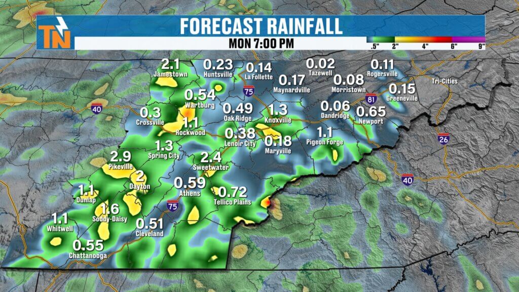
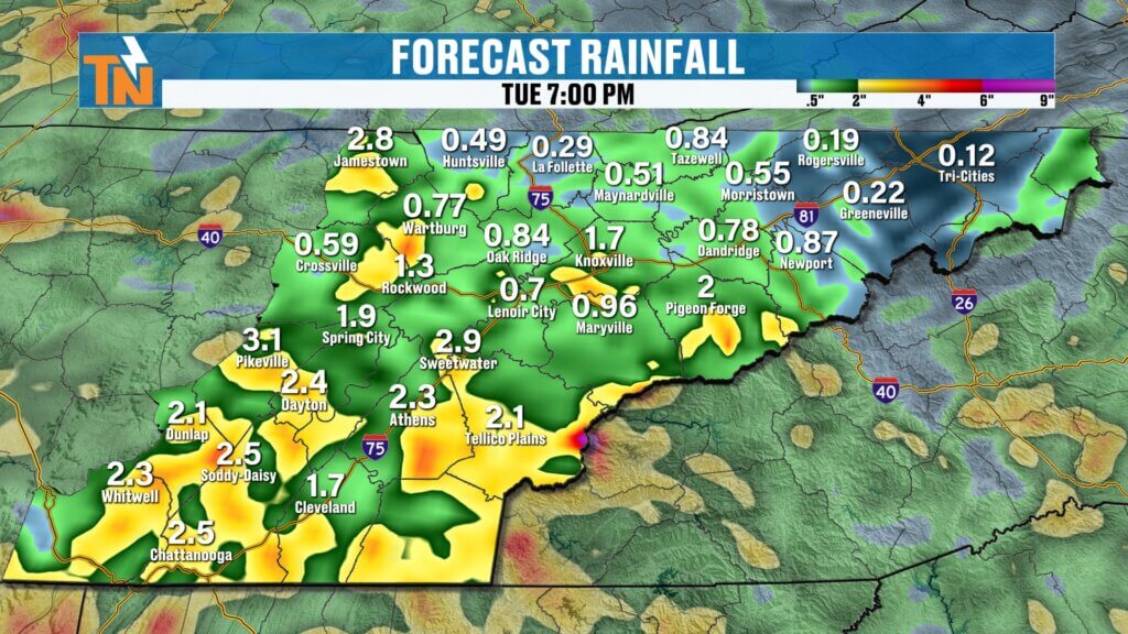
Rainfall Totals Will Vary Dramatically
One of the challenges with this type of weather pattern is forecasting exact rainfall amounts.
Computer models continue to indicate:
- Highest rainfall across the Cumberland Plateau
- Greater totals across the Southern Valley
- Lower coverage across portions of Upper East Tennessee
However, those numbers can change dramatically depending on where thunderstorms repeatedly develop.
Some model guidance has suggested isolated locations could receive several inches of rainfall.
That does not mean everyone will.
Instead, it highlights just how much moisture is available in the atmosphere.
The setup is similar to what produced significant flooding in parts of northern Alabama over the weekend.
The Heat and Humidity Continue
Even with all the rain chances, temperatures remain warm throughout the week.
Once the heaviest rain threat begins to diminish later this week, temperatures will start climbing again.
Forecast highs include:
Monday: Low 80s
Tuesday: Low 80s
Wednesday: Mid 80s
Thursday: Upper 80s
Friday: Upper 80s
Saturday: Near 90°
At the same time, dew points remain elevated in the upper 60s and lower 70s.
That means:
- Muggy mornings
- Tropical afternoons
- Warmer overnight temperatures
- Heat index values climbing into the 90s
By late week, East Tennessee will feel much more like mid-summer than early June.
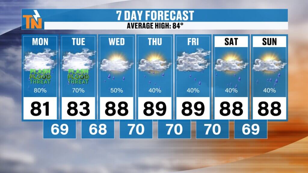
East Tennessee 7-Day Forecast
Monday:
- Numerous showers and thunderstorms
- Tropical downpours possible
- Flooding concerns
- High: 82°
Tuesday:
- More showers and thunderstorms
- Localized flooding possible
- High: 82°
Wednesday:
- Scattered storms continue
- Humid and warm
- High: 84°
Thursday:
- Fewer storms
- More sunshine
- High: 87°
Friday:
- Hot and muggy
- Isolated afternoon storms
- High: 88°
Saturday:
- Summer heat builds
- Spotty storms possible
- High: Near 90°
Sunday:
- Hot and humid
- Typical summertime pattern
- High: Upper 80s
Bottom Line
Today and Tuesday will be the most active weather days of the week.
The atmosphere is loaded with tropical moisture, creating the potential for slow-moving thunderstorms capable of producing intense rainfall rates and localized flooding.
Not everyone will experience flooding, but everyone should remain weather aware, especially if traveling during periods of heavy rain.
After the rain threat gradually eases later this week, East Tennessee will transition into a hotter and more humid summer pattern with temperatures approaching 90 degrees.
Have a great Monday, stay weather aware, and keep an eye on the radar as these tropical downpours begin developing across the region.