
Happy Sunday, everybody!
Thanks for checking in this morning. I hope you’re having a great weekend.
After another warm and mostly dry Saturday across East Tennessee, we’re beginning to see the weather pattern transition into something much more typical for June. The heat is sticking around, the humidity is increasing, and multiple rounds of showers and thunderstorms are expected as we head into the new week.
While today will still be one of the drier days in the forecast, the atmosphere is becoming increasingly moisture-rich. That means any storms that develop over the next several days will be capable of producing tropical-like downpours, localized flooding, and isolated flash flooding concerns.
Let’s break it all down.
Summer Humidity Continues to Build
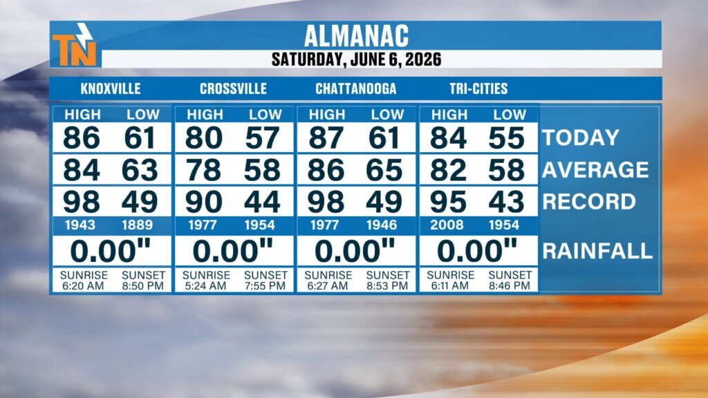
Yesterday’s temperatures climbed into the middle and upper 80s across much of East Tennessee.
- Chattanooga: 87°
- Knoxville: 86°
- Tri-Cities: Mid 80s
- Crossville: Lower 80s
Those temperatures are right around average to slightly above average for early June.
The bigger story, however, is the increasing humidity.
An upper-level disturbance moving out of the Southwest is beginning to interact with a steadily increasing supply of Gulf moisture. As this disturbance approaches, it will provide the energy needed to develop scattered showers and thunderstorms throughout the Tennessee Valley.
At the same time, atmospheric moisture levels continue to rise.
Meteorologists measure this using precipitable water values, which indicate how much moisture is available to be squeezed out of the atmosphere. The darker greens showing up on forecast models indicate significantly higher moisture content moving into the region.
The result will be a much more tropical feel to the air and the potential for very heavy rainfall over the coming days.
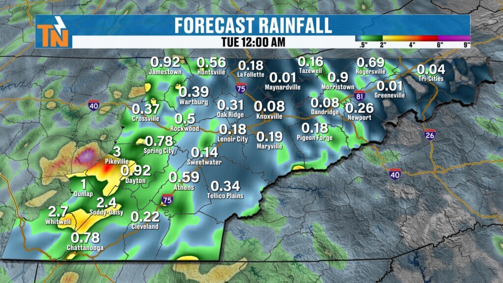
Flooding Concerns Increase This Week
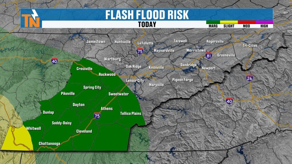
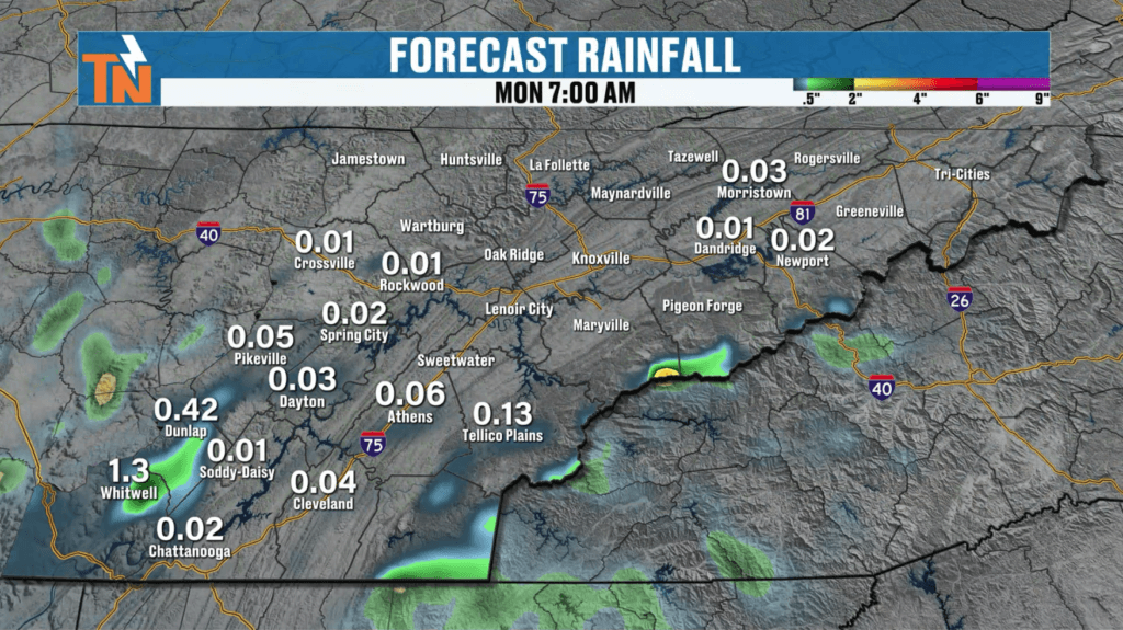
Because of the increasing moisture and repeated rounds of thunderstorms expected this week, the Weather Prediction Center has highlighted portions of East Tennessee for excessive rainfall concerns.
Today’s outlook includes a Level 1 risk for localized flooding, primarily along and south of Interstate 40 from Rockwood and Crossville southward through Tellico Plains and into the southern Tennessee Valley.
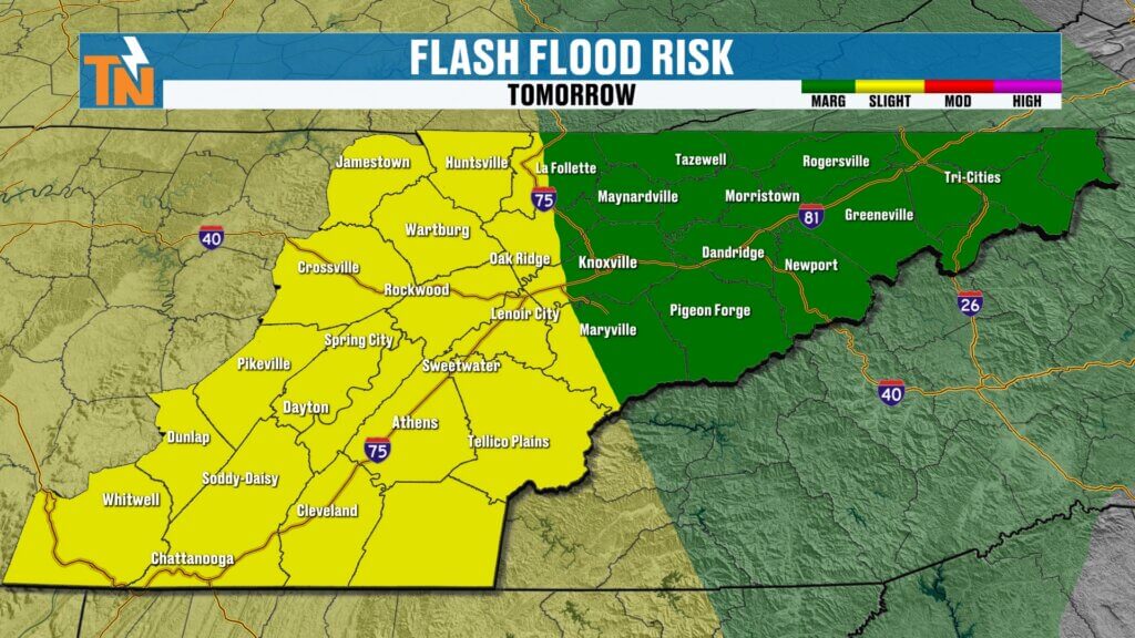
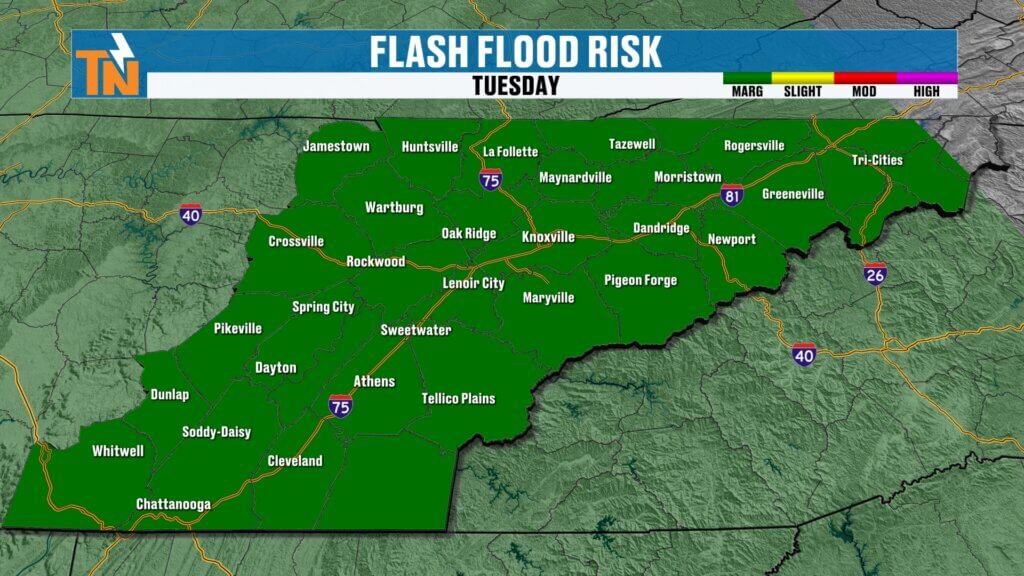
As we move into Monday and Tuesday, those concerns increase.
Current outlooks include:
- Monday into Tuesday: Level 1 and Level 2 flood risk
- Tuesday into Wednesday: Level 1 flood risk
The primary concern is not widespread river flooding but rather localized flooding and flash flooding caused by slow-moving thunderstorms repeatedly tracking over the same areas.
The good news is that East Tennessee continues to need rainfall due to ongoing drought concerns.
The challenge is that tropical-style downpours can quickly overwhelm drainage systems and produce flooding problems in isolated locations.
Sunday Forecast: Hot, Humid and Mostly Dry
Despite the increasing moisture, today remains one of the quieter days in the forecast.
Temperatures this morning are noticeably warmer than they were earlier this week.
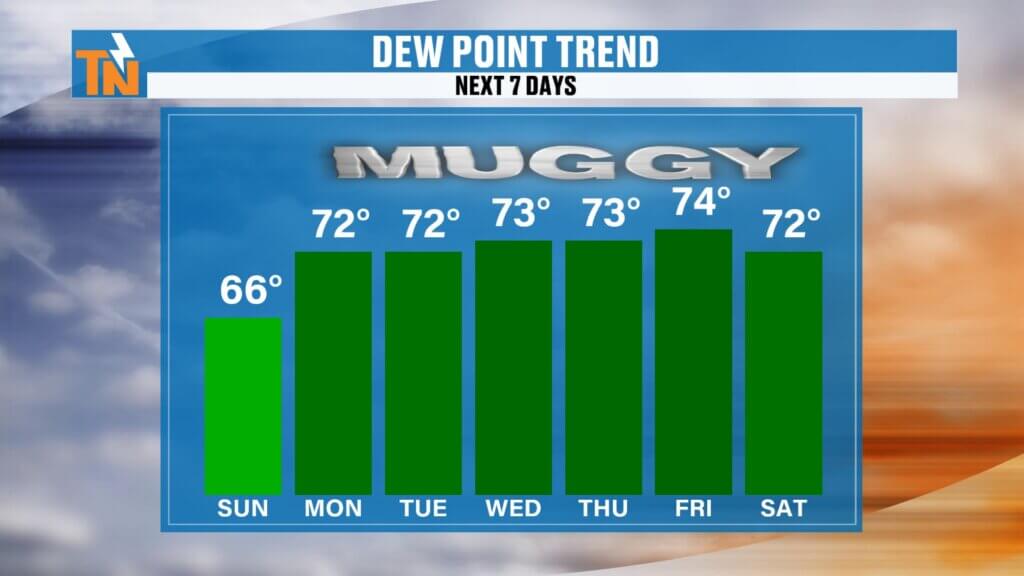
Most communities are waking up to readings in the middle and upper 60s, while dew points have climbed into the lower and middle 60s. That’s a clear sign that humidity levels are on the rise.
Expect:
- A mix of sunshine and clouds
- Increasing humidity
- Warm temperatures
- A slight chance of isolated showers and storms
Most locations will remain dry through lunchtime.
By afternoon, a few isolated showers and thunderstorms may develop, primarily across the southern Tennessee Valley and closer to Chattanooga.
Rain coverage today remains limited, with most communities staying dry.
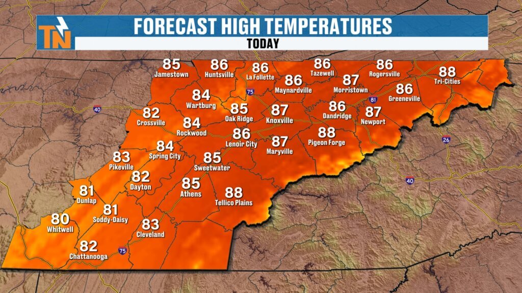
Forecast highs today include:
- Knoxville: 86° to 87°
- Chattanooga: Upper 80s
- Tri-Cities: Mid 80s
- Crossville: Lower 80s
If you have outdoor plans, today is still a great day to get outside before rain chances become much more widespread.
Monday Brings More Widespread Storm Activity
The weather pattern begins changing more noticeably Monday.
Several forecast models continue to suggest scattered showers may already be present Monday morning as the atmosphere becomes increasingly saturated.
However, the better opportunity for widespread rainfall arrives during the afternoon and evening.
As daytime heating combines with deep tropical moisture and incoming upper-level energy, thunderstorms are expected to become more numerous.
Some storms will be capable of producing:
- Very heavy rainfall
- Frequent lightning
- Localized flooding
- Ponding of water on roads
- Reduced visibility during downpours
Monday evening and Monday night currently appear to offer one of the better opportunities for widespread rainfall.
Tropical Downpours Continue Tuesday and Wednesday
The active pattern continues through midweek.
Additional disturbances moving through the atmosphere will interact with abundant moisture already in place, creating an environment favorable for repeated rounds of showers and thunderstorms.
One important note:
Do not focus too much on the exact rainfall totals shown by computer models.
The bigger story is the setup itself.
The atmosphere will contain plenty of moisture. Wherever storms repeatedly develop, rainfall amounts will quickly add up.
Some locations may receive very little rain while others just a few miles away could experience multiple inches of rainfall.
That’s the nature of tropical summer weather patterns in East Tennessee.
Why It Will Feel So Much More Uncomfortable
The increase in rainfall chances is directly tied to the increase in humidity.
Today’s dew points are generally in the middle 60s.
By Monday, Tuesday, and Wednesday, many locations could see dew points pushing 70 degrees.
When dew points reach that level:
- The air feels noticeably sticky
- Nights stay warmer
- Morning temperatures remain elevated
- Heat index values begin climbing
- Thunderstorm potential increases significantly
It’s the classic “air you can wear” feeling that East Tennesseans know all too well during June, July, and August.
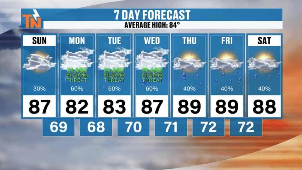
East Tennessee 7-Day Forecast
Sunday:
- Partly sunny
- Isolated afternoon showers
- High: 87°
Monday:
- Increasing humidity
- Scattered to numerous storms
- High: 84°
Tuesday:
- Tropical downpours possible
- Localized flooding concerns
- High: 82°
Wednesday:
- Continued showers and thunderstorms
- Heavy rainfall possible
- High: 82°
Thursday:
- Scattered storms remain possible
- Humid
- High: 84°
Friday:
- Hot and muggy
- Isolated afternoon storms
- High: 88°
Saturday:
- Very warm and humid
- Spotty afternoon storms
- High: Near 90°
Bottom Line
Today remains mostly dry, warm, and increasingly humid. The bigger changes arrive Monday through Wednesday as tropical moisture surges into East Tennessee and multiple disturbances move through the region.
Expect increasing chances for showers and thunderstorms, periods of heavy rainfall, and localized flooding concerns. The exact placement of the heaviest rain remains uncertain, but the atmosphere will be capable of producing tropical-like downpours wherever storms develop.
Stay weather aware this week, especially Monday through Wednesday, and continue checking forecast updates as rainfall and flooding concerns become better defined.
Have a great Sunday, everybody, and enjoy one more mostly dry day before the wetter pattern settles in.