
Happy Tuesday, everybody!
Thanks for checking in with your morning weather update. We have another active weather day ahead across East Tennessee as tropical moisture remains locked into the region. While not everyone saw heavy rain yesterday, some communities experienced significant rainfall totals, including flash flooding concerns around parts of northwest Knoxville.
Unfortunately, the setup responsible for yesterday’s heavy rain hasn’t changed much, and that means localized flooding and flash flooding remain possible again today.
Let’s break down everything you need to know.
Tropical Air Mass Remains Locked Over East Tennessee
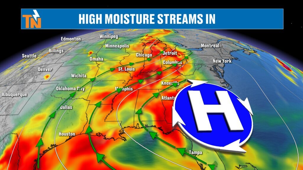
A ridge of high pressure continues to dominate the southeastern United States, but embedded disturbances moving around that ridge are creating the perfect environment for daily rounds of showers and thunderstorms.
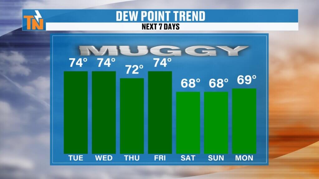
The atmosphere remains extremely moist with dew points sitting comfortably in the upper 60s and lower 70s. That tropical air mass isn’t going anywhere anytime soon.
One key disturbance currently moving in from the west will provide the lift needed to spark additional thunderstorms this afternoon and evening.
The combination of:
- High humidity
- Deep tropical moisture
- Afternoon heating
- Passing upper-level disturbances
will continue to generate scattered thunderstorms capable of producing very heavy rainfall.
Flash Flood Risk Continues Across East Tennessee
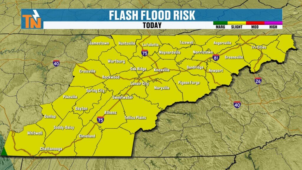
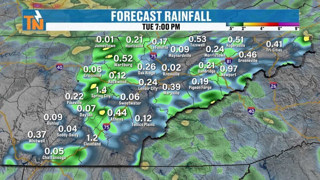
The Weather Prediction Center continues to highlight East Tennessee with a Level 2 risk for excessive rainfall and localized flash flooding.
While widespread flooding is not expected, isolated flooding remains a concern wherever storms repeatedly move across the same locations.
One of the biggest challenges with this pattern is that rainfall amounts vary dramatically over short distances.
Yesterday was a perfect example.
Some areas around northwest Knoxville received over 3.5 inches of rain, while other locations just a few miles away received little to no rainfall at all.
That same scenario is likely to play out again today.
Rainfall rates may still reach:
- 1 to 3 inches per hour in stronger storms
- Rapid ponding on roadways
- Localized street flooding
- Poor drainage flooding
- Isolated flash flooding
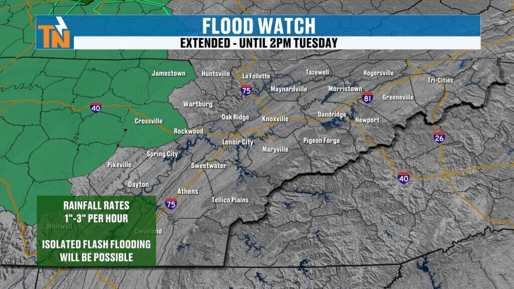
At this time, Flood Watches remain in effect for portions of the Cumberland Plateau, including Cumberland and Fentress Counties, while additional watches could be issued depending on how storms evolve later today.
Morning Forecast: Warm, Humid and Increasingly Unstable
Temperatures are once again running warmer than yesterday morning.
Most communities are starting the day in the:
- Upper 60s
- Lower 70s
Combined with dew points in the upper 60s and lower 70s, it already feels like a midsummer morning across the Tennessee Valley.
The trend of warmer mornings has continued for nearly a week now, signaling the increasingly tropical nature of the air mass.
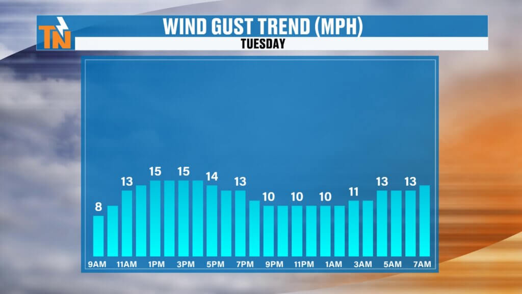
Winds will be slightly stronger today as the approaching disturbance moves closer, helping provide additional energy for storm development later this afternoon.
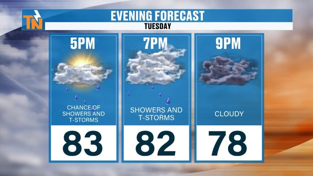
Afternoon Storms Become the Main Concern
Like yesterday, scattered showers are already developing this morning.
However, the greatest coverage and intensity of rainfall is expected during the afternoon and evening hours when daytime heating adds instability to the atmosphere.
Between noon and sunset:
- Thunderstorms become more widespread
- Locally heavy downpours develop
- Frequent lightning is possible
- Visibility may rapidly decrease during heavier storms
- Flooding concerns increase
The good news is that storms should move a little faster than they did yesterday.
Yesterday’s storms were nearly stationary in some areas, which contributed to excessive rainfall totals. Today’s storms should have a bit more movement, reducing—but not eliminating—the flash flood threat.
Why Some Areas Will Flood While Others Stay Dry
This remains one of the most frustrating forecast patterns for viewers.
Many people woke up yesterday saying they never received a drop of rain, while others dealt with flooded roads and several inches of rainfall.
That’s because these storms are highly localized.
Think of it this way:
One neighborhood could receive 3 inches of rain in an hour, while another community five miles away receives nothing at all.
That trend continues today.
Everyone has the opportunity for rain, but not everyone will experience flooding.
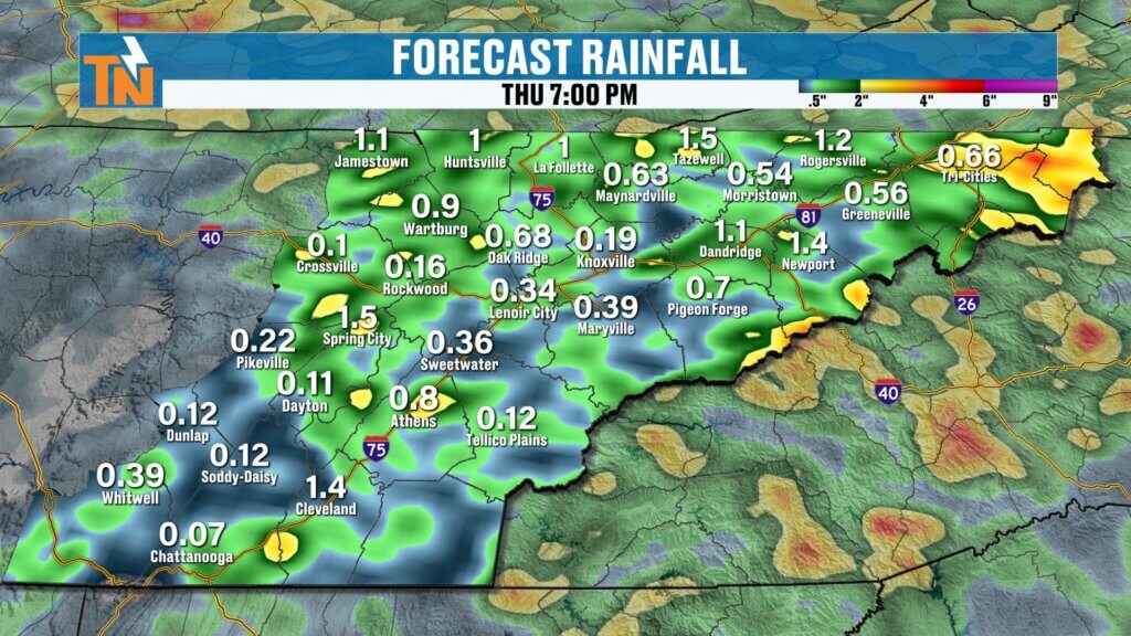
More Rain Ahead Wednesday
The active weather pattern doesn’t end today.
Another disturbance arrives on Wednesday, bringing another round of scattered showers and thunderstorms.
The Weather Prediction Center continues to highlight portions of East Tennessee for excessive rainfall concerns Wednesday as well.
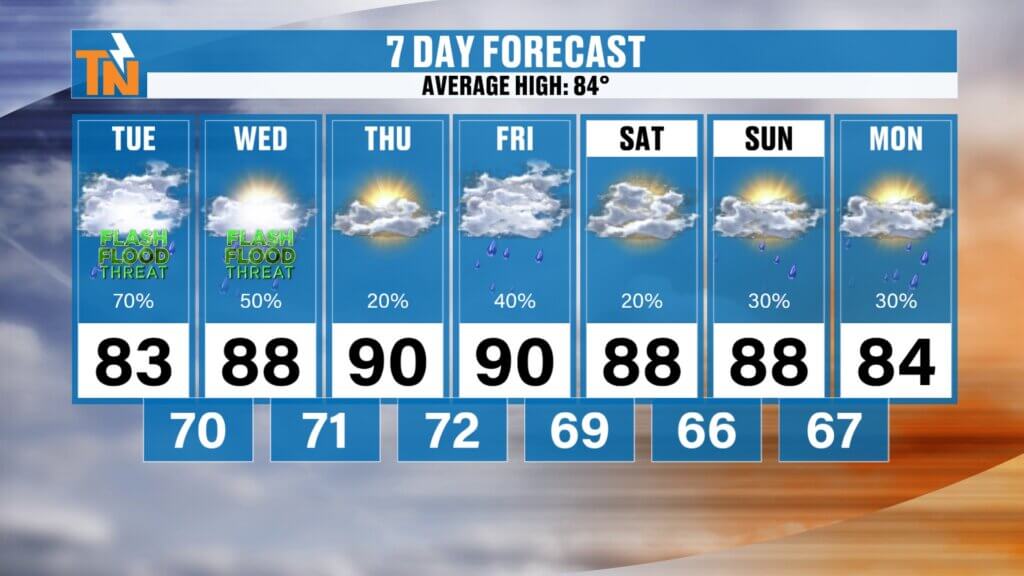
Rain chances remain elevated:
- Tuesday: 70%
- Wednesday: 50%
- Thursday: 20%
- Friday through Sunday: Typical summertime pop-up storms
By late week, the pattern becomes less organized, shifting toward a more traditional June weather setup with isolated afternoon thunderstorms.
Heat and Humidity Begin to Build
While we’re focused on flooding concerns today, another weather story is quietly developing.
The heat is about to increase.
High temperatures are expected to climb into:
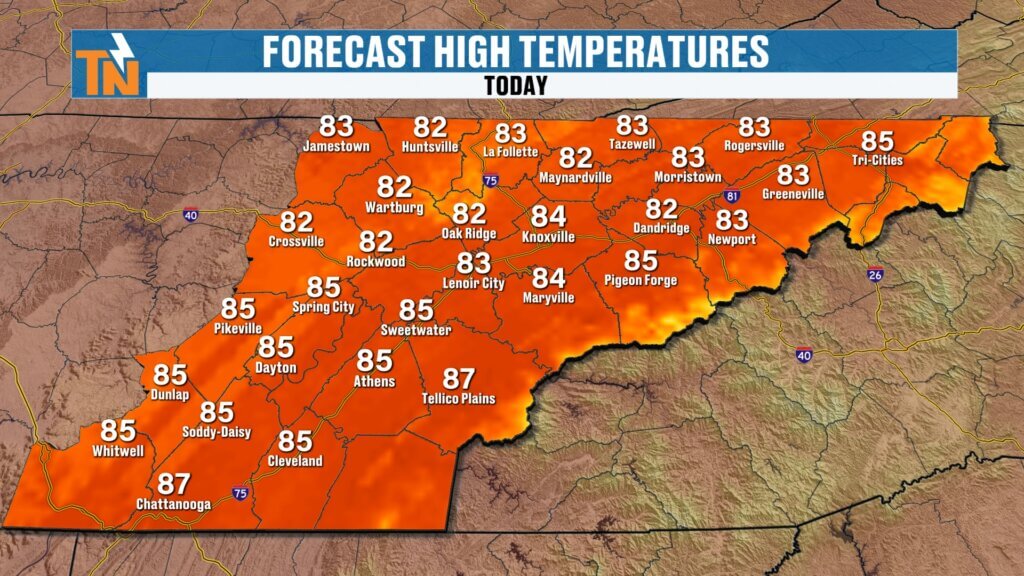
Tuesday: Mid 80s
Wednesday: Upper 80s
Thursday: Near 90°
Friday: Near 90°
Saturday: Upper 80s to Near 90°
Sunday: Upper 80s to Near 90°
When combined with dew points remaining near 70 degrees, heat index values will begin pushing well into the 90s.
By late week, East Tennessee will feel much more like July than early June.
Long-Range Outlook
Looking beyond the seven-day forecast, the Climate Prediction Center continues to favor:
- Above-average temperatures
- Above-average rainfall
- Continued opportunities for thunderstorms
Forecast guidance through the middle of June suggests additional rounds of rainfall remain possible, helping chip away at lingering drought concerns across portions of East Tennessee.
East Tennessee 7-Day Forecast
Tuesday:
- Scattered thunderstorms
- Localized flooding possible
- High: 85°
Wednesday:
- More showers and storms
- Heavy rain possible
- High: 87°
Thursday:
- Partly sunny
- Isolated afternoon storm
- High: 89°
Friday:
- Hot and humid
- Isolated storm
- High: 90°
Saturday:
- Summerlike conditions
- Spotty afternoon storm
- High: 89°
Sunday:
- Hot and muggy
- Isolated storms
- High: 89°
Monday:
- Continued heat and humidity
- Scattered afternoon storms
- High: Upper 80s
Bottom Line
The biggest concern today remains localized flooding and flash flooding from slow-moving thunderstorms capable of producing torrential rainfall.
Not everyone will receive heavy rain, but those who do could see rainfall rates of 1 to 3 inches per hour.
Stay weather aware this afternoon and evening, especially if you’re traveling. Never drive through flooded roadways, and keep an eye on the radar as storms begin developing.
Then get ready for the next weather story: increasing heat and humidity as East Tennessee heads deeper into June.
Have a great Tuesday, stay safe, and make it the best Taco Tuesday possible!