
Published: Saturday, July 25, 2025
By Meteorologist Mike Witcher | eastTNweather
Happy Saturday, everybody!
If you’re waking up to rain this morning, don’t worry—this isn’t going to be an all-day washout.
We’ve been tracking another disturbance diving southeast through the Tennessee Valley overnight, bringing areas of light to occasionally moderate rain across East Tennessee early this morning. The good news is that once this wave moves through, we’ll gradually begin to dry out with improving conditions during the afternoon.
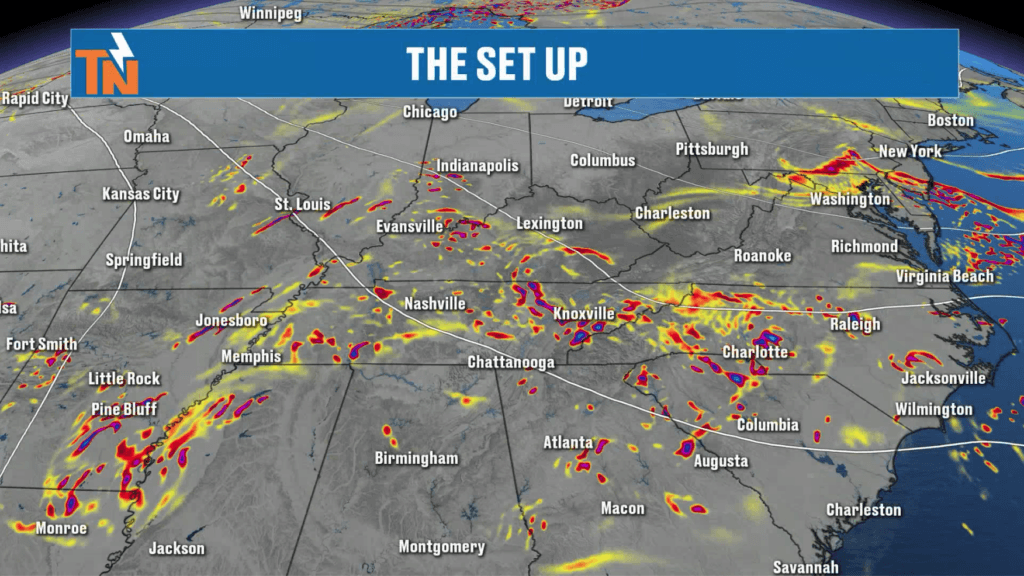
A Northwest Flow Pattern Continues
The overall weather pattern hasn’t changed much.
A broad trough remains across the eastern United States while high pressure sits over the Four Corners region. That keeps us in a northwesterly flow aloft, allowing small disturbances to continue sliding into East Tennessee every couple of days.
Today’s wave is responsible for the rain we’re seeing this morning. It’s also interacting with a weak surface boundary just south of Tennessee, helping focus the rainfall across parts of the region.
As this disturbance exits later today, we’ll lose much of our forcing, and rain coverage will decrease significantly.
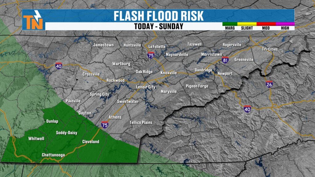
Flooding Risk Remains Low… But Not Zero
Even though rainfall will be much lighter than we’ve dealt with recently, the Weather Prediction Center continues to highlight portions of East Tennessee under a Level 1 risk for localized flooding and flash flooding.
This isn’t because today’s rainfall is expected to be excessive.
Instead, it’s because portions of the southern Valley have already picked up significant rainfall over the past several days. It simply won’t take much additional rain to create isolated standing water in those locations.
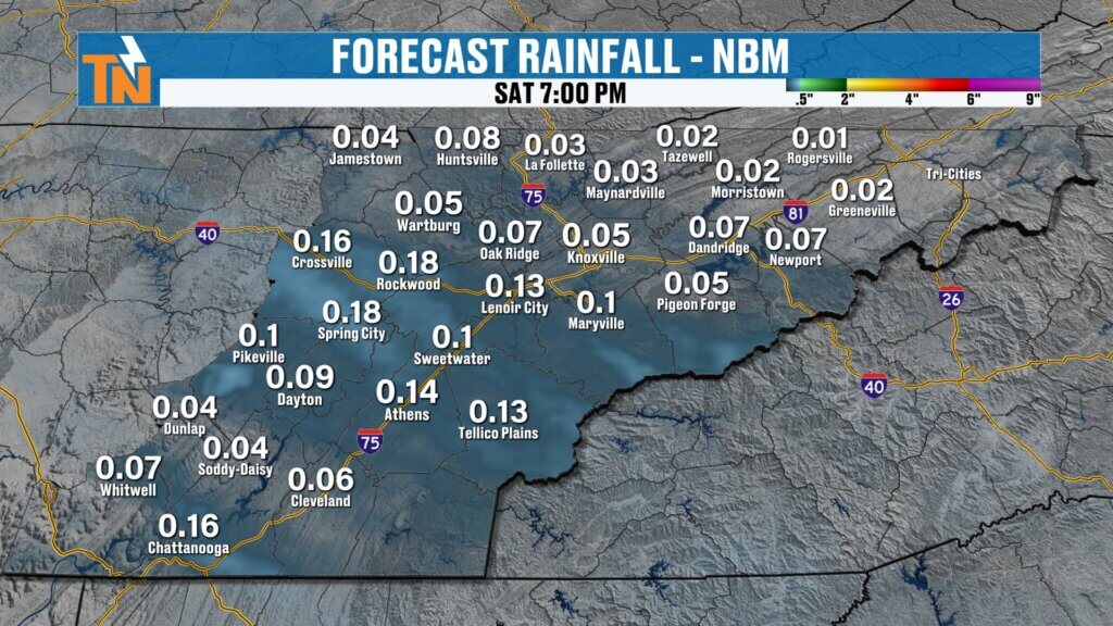
Morning Rain… Better Weather This Afternoon
Radar early this morning shows showers moving from northwest to southeast across East Tennessee.
That rain should gradually diminish through mid to late morning.
By lunchtime and into the afternoon, many communities should simply be dealing with mostly cloudy skies with only a few isolated spotty showers remaining.
If you have outdoor plans today, don’t cancel them.
Just expect a damp start before conditions steadily improve through the afternoon.
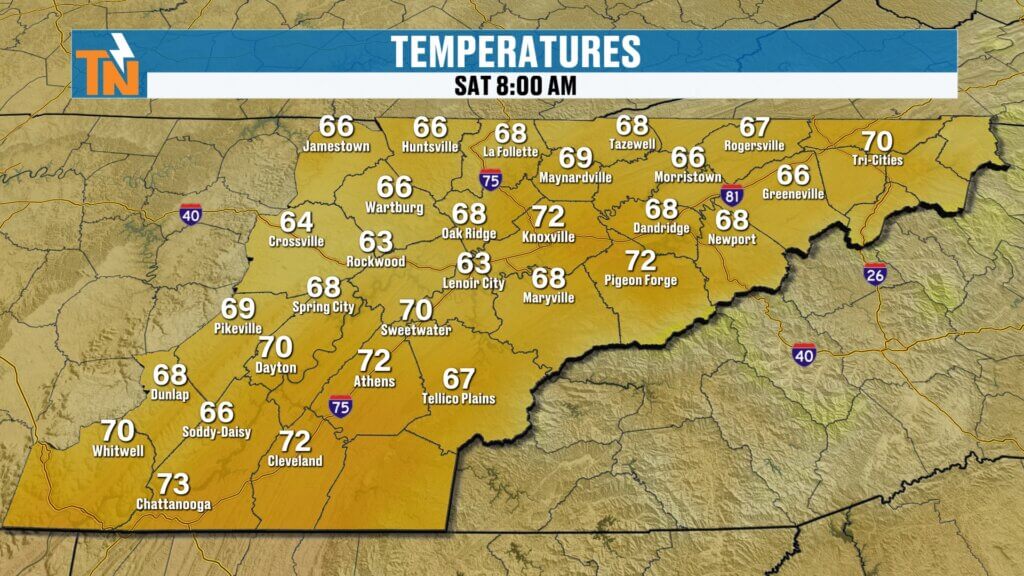
Comfortable Temperatures Today
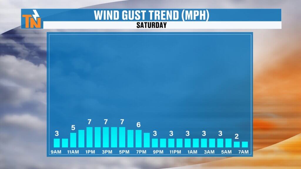
Temperatures started the morning in the upper 60s and lower 70s with light winds and plenty of humidity.
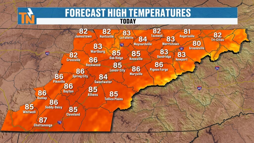
Cloud cover will keep temperatures below average this afternoon, with highs reaching:
- Lower 80s across the Plateau
- Mid 80s across much of the Tennessee Valley
- A few upper 80s across the southern Valley
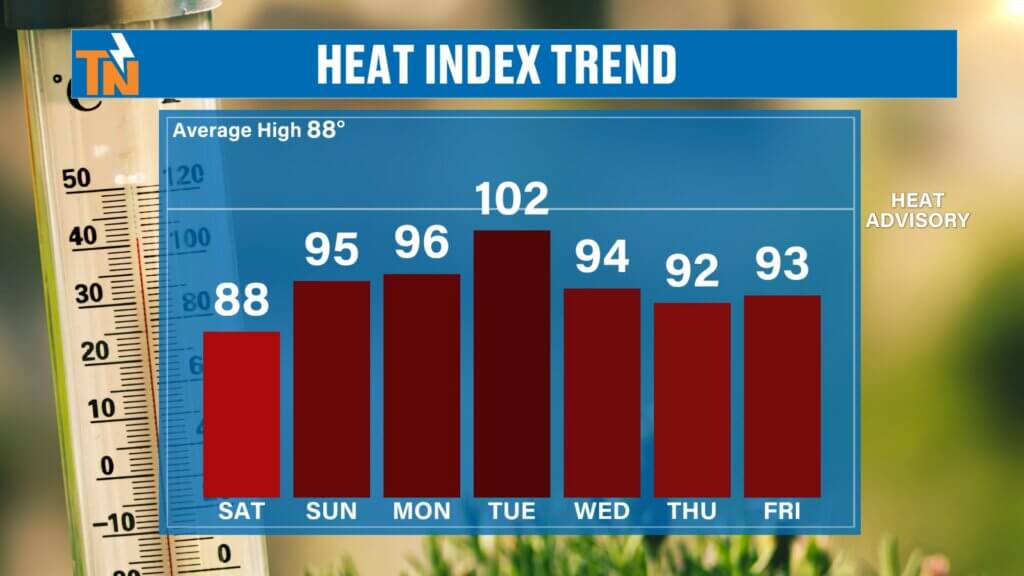
Because of the clouds, today’s heat stress remains relatively low compared to what we’ll experience early next week.
Another Weak Wave Arrives Tonight
One more disturbance slides through overnight tonight.
That means another batch of light rain may develop late tonight into early Sunday morning.
Rainfall should once again be fairly light, and by Sunday afternoon we’ll begin seeing increasing sunshine with much lower rain coverage.
Overall, Sunday looks like another excellent day to spend outdoors.
The Heat Begins Building Again
Rain chances stay relatively low through Monday before another disturbance arrives Tuesday.
Tuesday is still shaping up to be the hottest day of the upcoming week.
Forecast heat index values could climb between 100° and 107°, especially across the southern Valley, where heat headlines may become necessary.
We’ll also see the return of scattered afternoon thunderstorms as the heat and humidity increase.
7-Day Forecast Highlights
Central Valley (Knoxville)
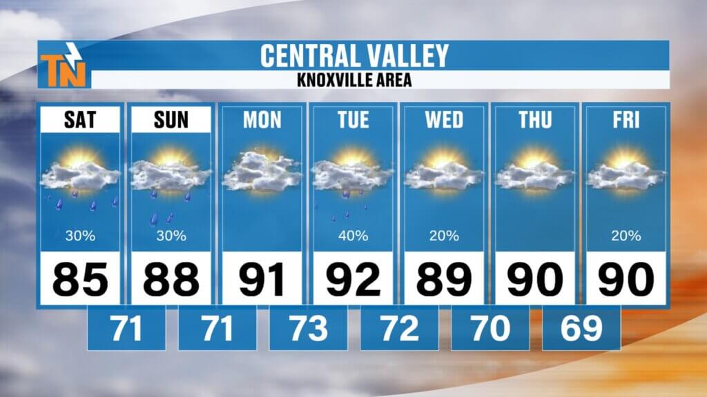
- Saturday: Morning rain, improving afternoon, high in the mid 80s
- Sunday: Morning shower possible, partly cloudy afternoon, upper 80s
- Monday: Dry and hot near 90°
- Tuesday: Hottest day with scattered afternoon storms
- Wednesday-Friday: Near 90° with isolated summertime storms
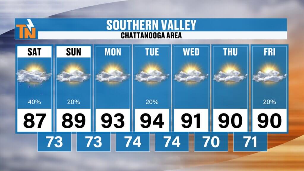
Southern Valley (Chattanooga)
- Mid 80s today
- Near 90° Sunday and Monday
- Tuesday reaches the mid 90s with heat index values approaching 107°
- Isolated afternoon storms continue through the week
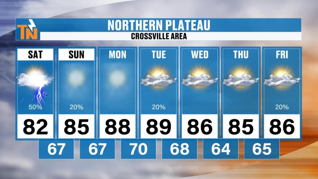
Cumberland Plateau
- Comfortable today in the lower 80s
- Upper 80s Sunday and Monday
- Tuesday brings hotter temperatures and scattered afternoon storms
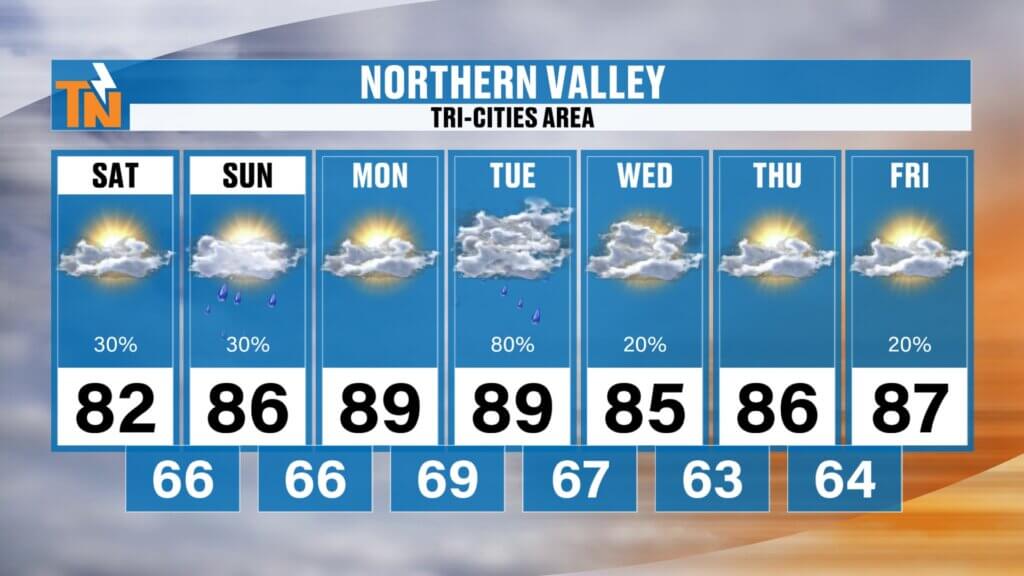
Northern Valley & Tri-Cities
- Pleasant today with only a small chance of rain
- Drying out Sunday afternoon
- Tuesday features the best chance for afternoon thunderstorms and the hottest temperatures of the week
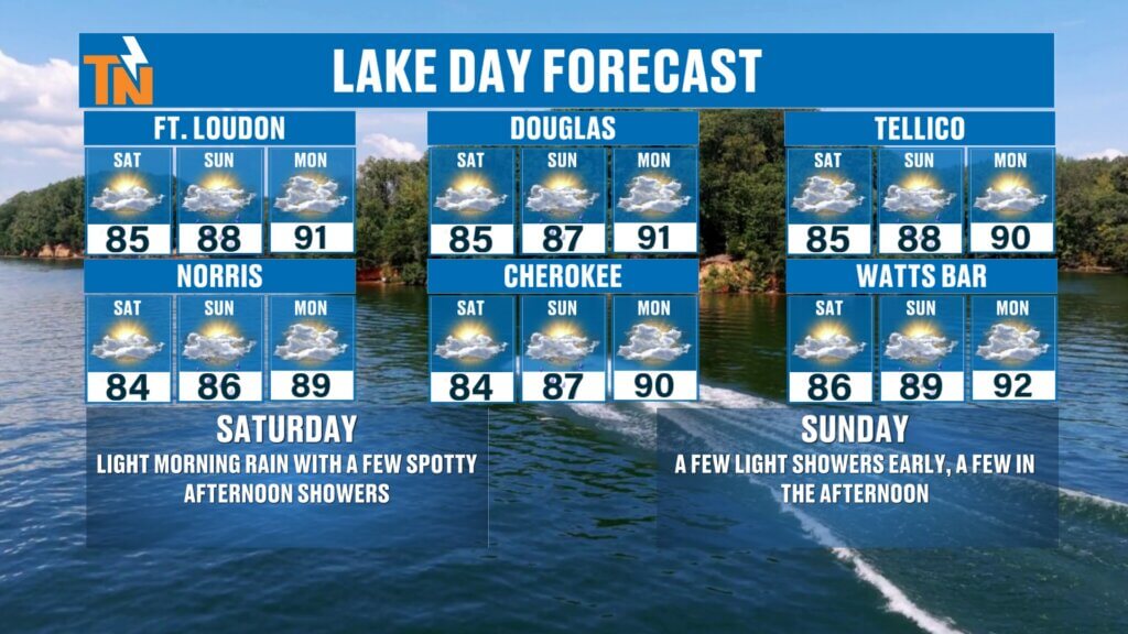
Boating Forecast
This weekend still looks favorable if you’re planning time on the water.
Saturday
- Light morning rain
- Improving conditions this afternoon
- Only isolated showers after lunch
Sunday
- A few early morning showers
- Increasing sunshine during the afternoon
- Excellent boating weather by late day
Whether you’re heading to Fort Loudoun, Douglas, Tellico, Watts Bar, Cherokee, or Norris Lake, keep the FREE eastTNweather app handy.
The app travels with you wherever you go and provides:
- Interactive radar
- Lightning alerts within 15 miles
- Past, current, and two-hour future radar
- Live severe weather updates when needed
Bottom Line
- Morning rain tapers off this afternoon.
- Don’t cancel outdoor plans.
- Another light round of rain arrives late tonight into early Sunday.
- Sunday afternoon looks much better.
- Hotter weather returns Monday and peaks Tuesday with heat index values over 100°.
Have a fantastic Saturday, and thanks for trusting eastTNweather as your local weather source.
East Tennessee weather, Knoxville weather, Tennessee weekend forecast, Saturday weather, East Tennessee rain, Knoxville rain forecast, lake forecast, Norris Lake weather, Douglas Lake weather, Tellico Lake weather, heat index Tennessee, summer weather Tennessee
#EastTNWeather #KnoxvilleWeather #TennesseeWeather #EastTennessee #TNwx #Knoxville #WeekendForecast #LakeWeather #BoatingForecast #SummerWeather #HeatIndex #MikeWitcher #WeatherUpdate