
Published: Tuesday, July 28, 2026
By Meteorologist Mike Witcher | eastTNweather
A Cold Front Brings Our Best Chance for Strong Storms
We’ve been tracking this setup for several days, and today is the day a cold front finally pushes into East Tennessee.
Overnight, one disturbance moved through the area, but it weakened significantly before arriving, leaving most of us with very little rainfall. That doesn’t mean we’re in the clear.
A second disturbance, combined with the approaching cold front and an extremely unstable atmosphere, will provide the ingredients needed for scattered showers and thunderstorms this afternoon and evening.
Not everyone will see storms, but the storms that do develop could become strong.
Severe Weather Risk Remains in Place
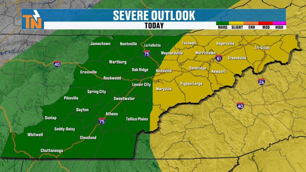
The Storm Prediction Center continues to place portions of East Tennessee under a Level 1 (Marginal Risk) and Level 2 (Slight Risk) for severe thunderstorms.
The Slight Risk has shifted a little farther east since yesterday, focusing more on the mountains and into western North Carolina, but portions of East Tennessee remain included.
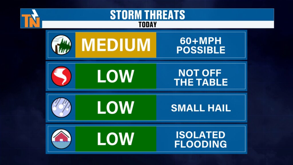
Primary Threats Today
- Damaging straight-line winds remain the biggest concern.
- An isolated tornado cannot be ruled out, although the threat remains low.
- Frequent lightning will accompany any stronger storm.
- Large hail is not expected to be a widespread issue.
- Flooding concerns remain limited, although localized heavy downpours are certainly possible.
Models Continue to Disagree
One of the biggest forecast challenges today is model inconsistency.
Last night’s high-resolution model painted a fairly robust line of thunderstorms moving through East Tennessee during the afternoon.
However, this morning’s newest run of the same model significantly reduced storm coverage, suggesting only isolated development.
Even my in-house model has backed away from widespread storms.
Does that mean storms won’t happen?
Absolutely not.
It simply highlights how difficult these summertime severe weather setups can be.
With:
- A cold front providing lift,
- A disturbance moving through the upper atmosphere,
- Very hot and humid conditions,
- And an unstable atmosphere,
there’s still every reason to remain weather aware today.
Forecast confidence is highest that some storms will develop, but exactly where they form remains uncertain.
Heat Will Fuel Today’s Storms
Before storms arrive, it will become extremely hot and humid.
Morning temperatures are already warmer than yesterday, with readings holding in the 70s.
This afternoon:
- High temperatures climb into the lower to middle 90s.
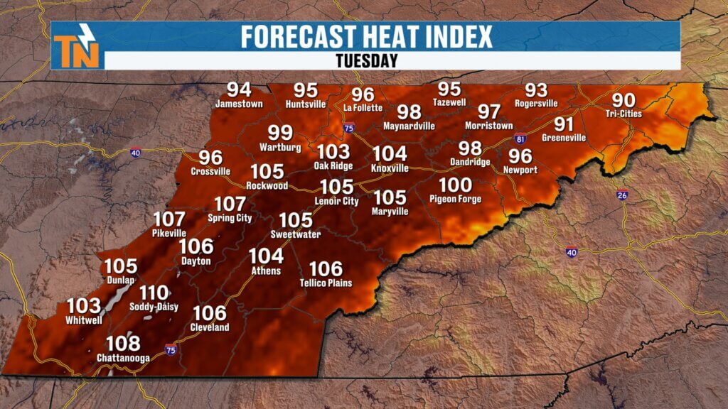
- Heat index values reach 100° to 105° across much of East Tennessee.
- Chattanooga could briefly approach 110°.
Winds will also become breezy ahead of the cold front, and any thunderstorm that develops will have no trouble producing damaging wind gusts.
Heat Safety Remains Critical
Today is expected to be the hottest day of the upcoming week.
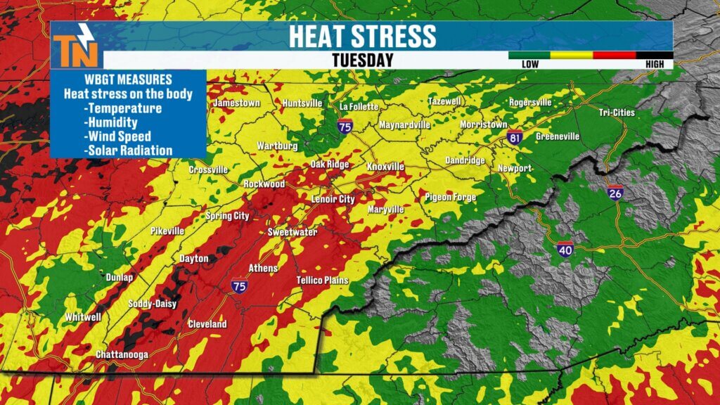
Wet Bulb Globe Temperature values continue climbing into levels that require additional precautions for outdoor activities.
Whether you’re:
- Working outside,
- Coaching sports,
- Attending practice,
- Or simply spending time outdoors,
today is a day to take frequent breaks, stay hydrated, and limit prolonged exposure during the hottest part of the afternoon.
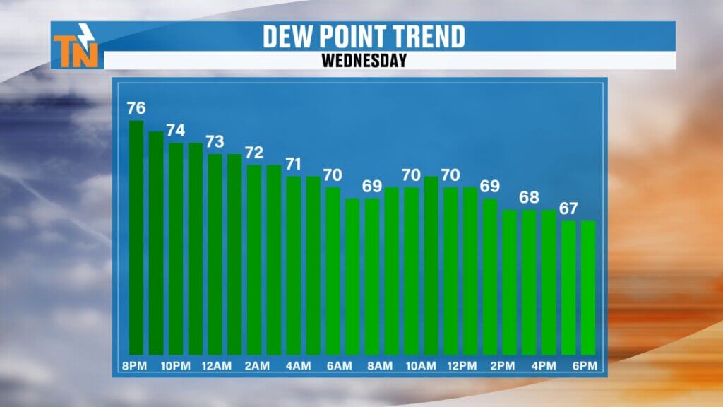
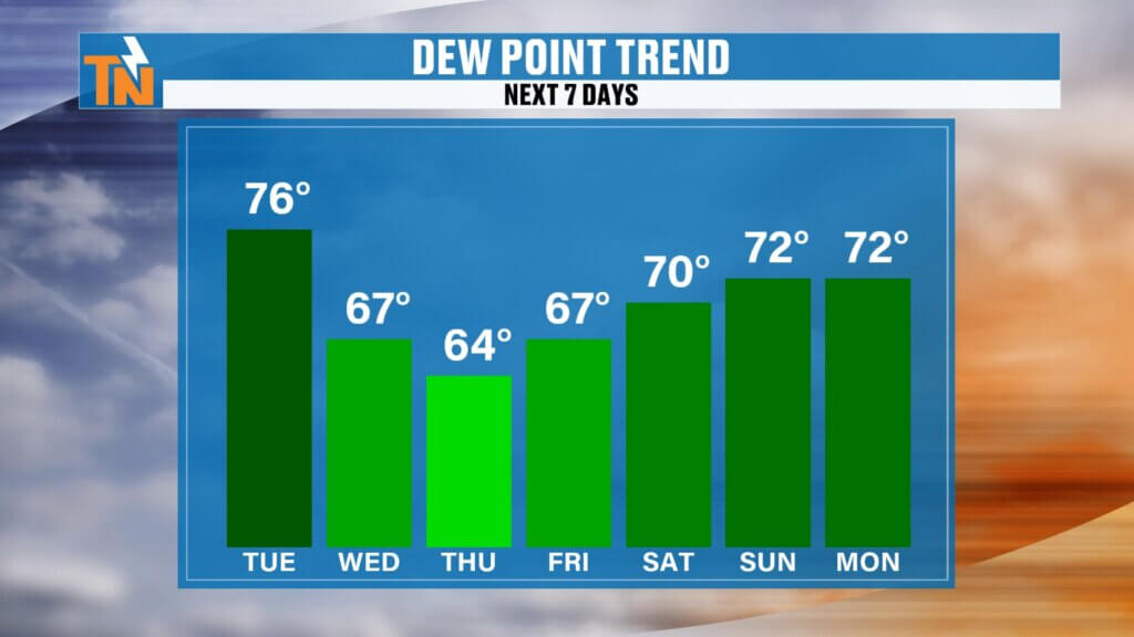
Relief Arrives Tonight
Once today’s storms move east this evening, the weather pattern begins changing for the better.
Behind the cold front:
- Dew points fall noticeably.
- Humidity decreases.
- Heat index values drop.
- Wednesday through Friday become much more comfortable.
It won’t feel like fall, but it will certainly be a welcome break from the tropical air we’ve been dealing with recently.
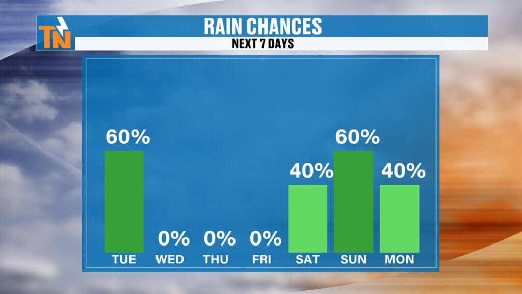
Weekend Forecast Already Turning Active Again
Enjoy the break while it lasts.
Humidity begins increasing again this weekend as another upper-level disturbance approaches the Tennessee Valley.
Some of the latest forecast guidance even hints that this disturbance could slow down and become a weak upper-level closed low, which would increase shower and thunderstorm chances Saturday and Sunday.
Forecast confidence for the weekend is still moderate, but it’s certainly something we’ll continue watching closely.
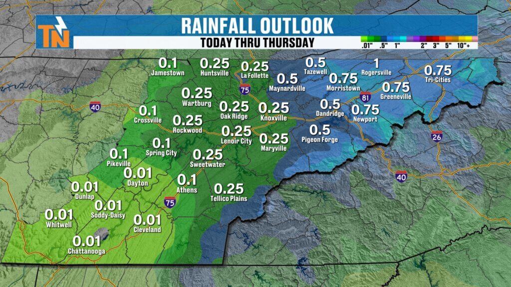
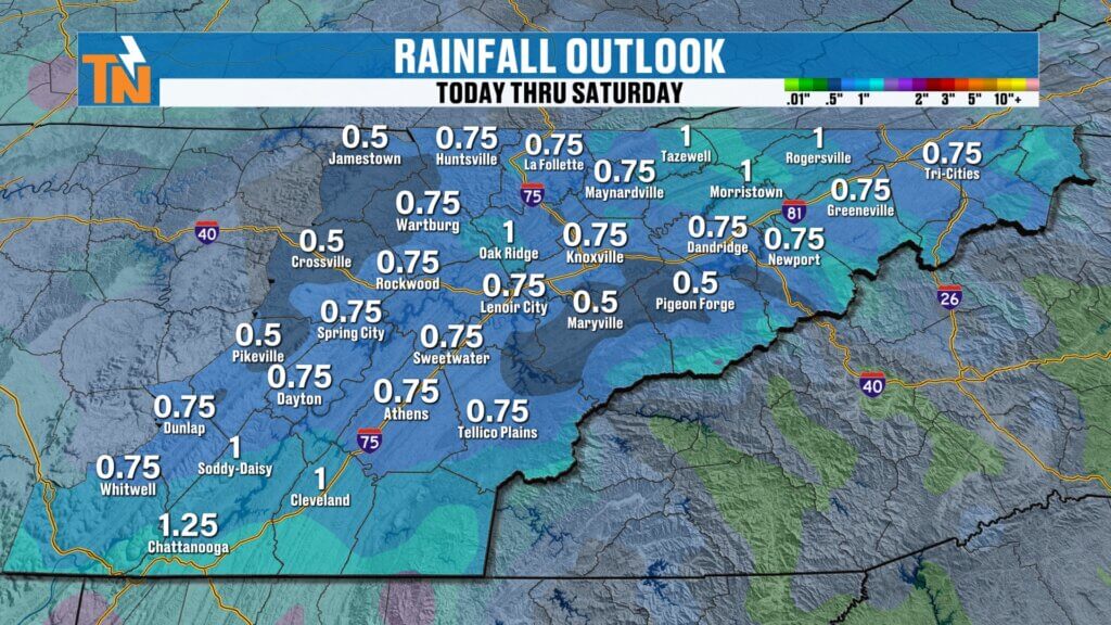
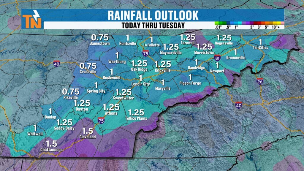
Rainfall Outlook
Most of this week’s rainfall is expected today as the cold front moves through.
By Friday night and especially Saturday into Sunday, rain chances begin increasing once again, with scattered showers and thunderstorms returning to the forecast.
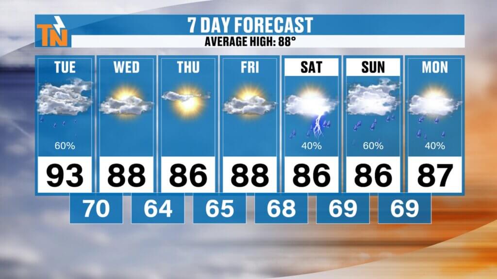
7-Day Forecast
Central Valley (Knoxville)
- Tuesday: 93°, strong storms possible, heat index over 100°
- Wednesday-Friday: Mid to upper 80s with lower humidity
- Saturday-Sunday: Mid 80s with increasing showers and thunderstorms
Southern Valley (Chattanooga)
The hottest temperatures remain across the Southern Valley today, where heat index values could briefly exceed 105°before much more comfortable air arrives Wednesday.
Cumberland Plateau
A much more pleasant stretch arrives Wednesday through Friday before rain chances increase again over the weekend.
Northern Valley & Tri-Cities
Storm coverage today may be greatest across Upper East Tennessee before noticeably drier weather settles in for the second half of the week.
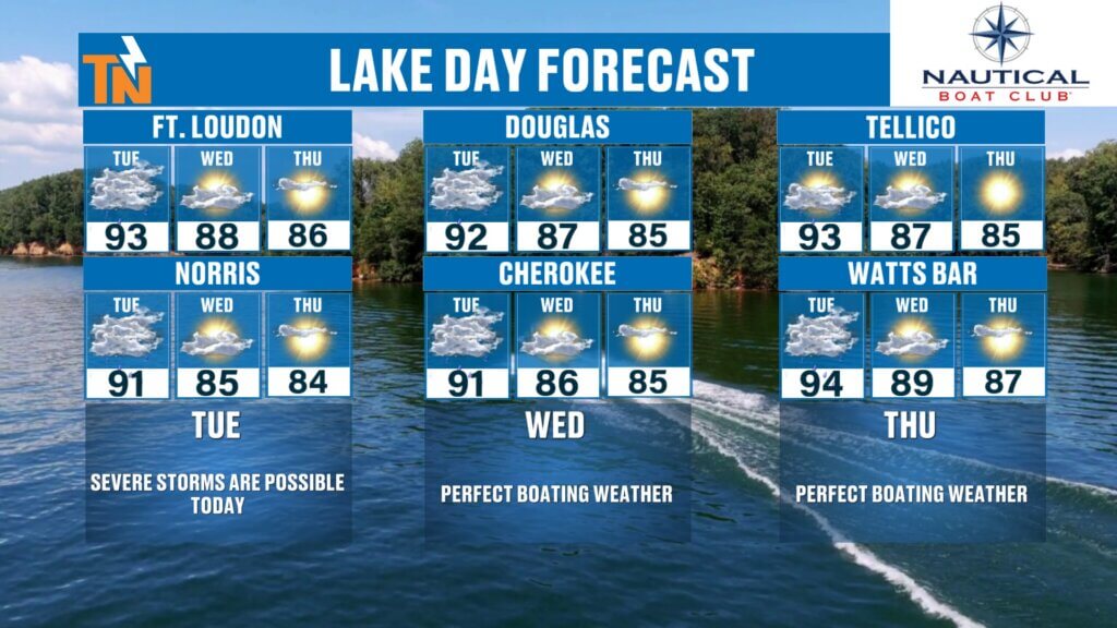
Lake Forecast
Today
Not the best boating day.
Strong thunderstorms could develop this afternoon, bringing dangerous lightning and gusty winds.
Wednesday through Friday
Outstanding lake weather returns with lower humidity and plenty of sunshine.
Weekend
If you’re planning time on the water, keep checking back. Rain and storm chances increase again Saturday and Sunday as another disturbance approaches.
Bottom Line
- Today is the hottest day of the week.
- Strong to severe thunderstorms remain possible this afternoon and evening.
- Damaging winds are the primary threat.
- A few storms could produce isolated tornadoes, but that risk remains low.
- Humidity drops noticeably Wednesday through Friday.
- Rain chances return next weekend.
Stay weather aware today, keep the FREE eastTNweather App handy for lightning alerts and interactive radar, and I’ll keep you updated throughout the day if conditions begin to change.
Have a great Tuesday, and once again… Happy Birthday, Janelle! ?❤️
High-Search SEO Keywords
East Tennessee weather, Knoxville weather, Tennessee severe weather, Knoxville storm forecast, East Tennessee forecast, severe thunderstorms today, Tennessee cold front, Knoxville heat index, East Tennessee radar, East Tennessee weather app, Mike Witcher, Chattanooga weather, Tri-Cities weather, Tennessee weather update
Hashtags
#EastTNWeather #TNwx #KnoxvilleWeather #SevereWeather #StormAlert #DamagingWinds #Thunderstorms #HeatIndex #Lightning #ColdFront #WeatherUpdate #MikeWitcher #EastTennessee #StayWeatherAware