
Published: Friday, August 7, 2026
By Meteorologist Mike Witcher | eastTNweather
Happy Friday, everybody!
We’ve made it to the end of another workweek, and our forecast is starting to sound a little familiar: wash, rinse, repeat.
Scattered afternoon showers and thunderstorms remain possible today, we’ll likely see a little better coverage Saturday, and then Sunday looks like the best day of the weekend if you’re trying to get outside or hit the lake.
A Water-Loaded Atmosphere Remains
Yesterday, temperatures climbed into the upper 80s and low 90s across portions of the Central Valley, while the Cumberland Plateau stayed mainly in the lower 80s.
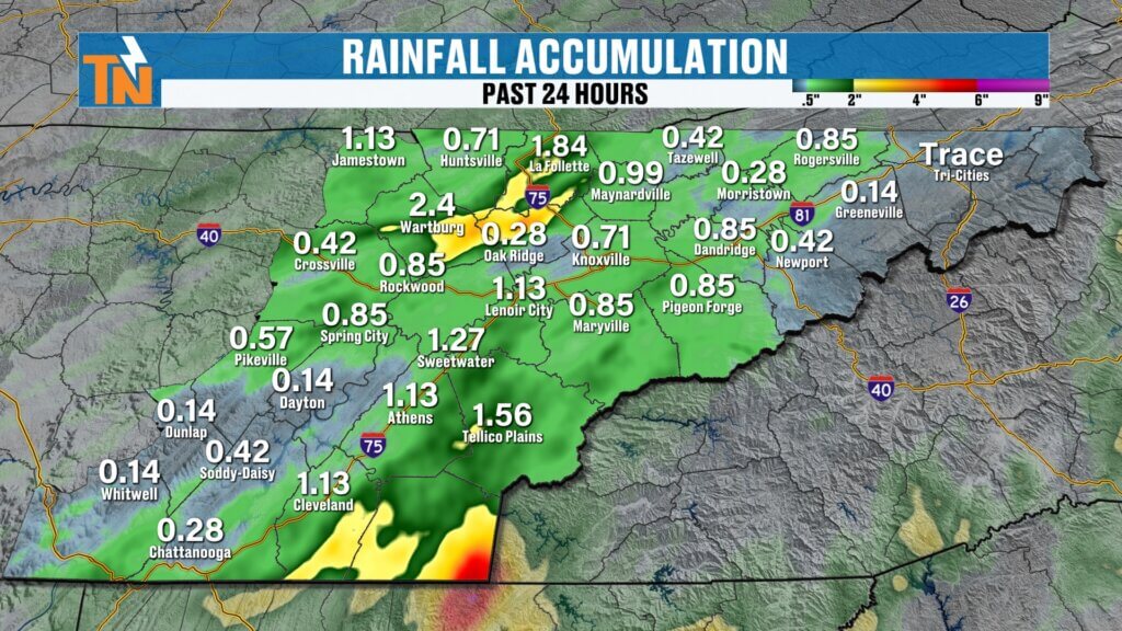
Rainfall was once again very hit-or-miss.
The majority of the rain developed across portions of the western Valley and Cumberland Plateau, although a few healthy downpours also popped up around Knox County.
That’s summertime convection for you. One neighborhood can get soaked while another just a few miles away stays completely dry.
And we’ll do it again today.
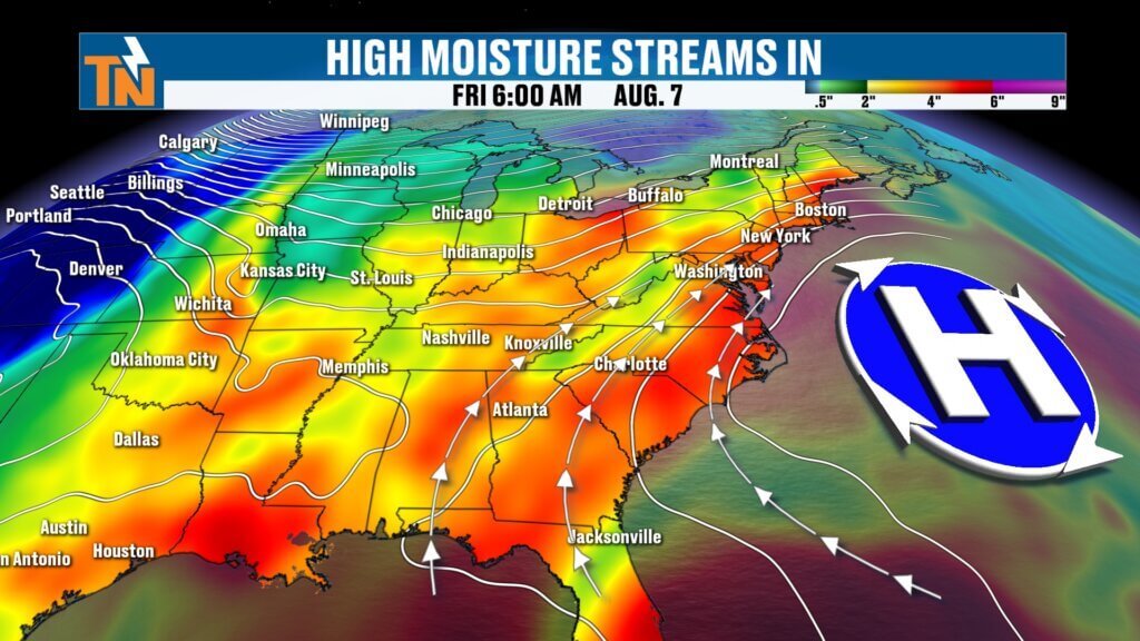
High pressure anchored off the East Coast continues pumping moisture into our region. That leaves us with a water-loaded atmosphere, meaning any storm that develops will be capable of producing a quick, heavy downpour.
Because of that, there remains a risk for localized flooding, particularly in urban and poor-drainage areas underneath the heaviest storms.
Friday: Most of the Day Is Fine
Don’t cancel your Friday plans.
The morning through lunchtime should remain mainly quiet. As we heat the atmosphere this afternoon, scattered showers and thunderstorms will begin developing—initially favoring the Cumberland Plateau and mountain counties.
Outflow boundaries from those storms may then kick off additional development across portions of the Valley.
Coverage doesn’t look particularly impressive, though. In fact, today should be fairly similar to Thursday.
That means not everyone gets rain.
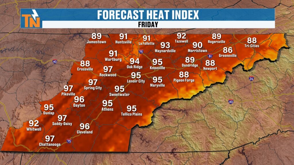
Temperatures climb into the upper 80s and lower 90s with heat index values generally reaching the low to mid 90s.
If you work outside—or if the kids have outdoor practices—the heat stress will be elevated enough that you’ll want to pay attention and take appropriate breaks.
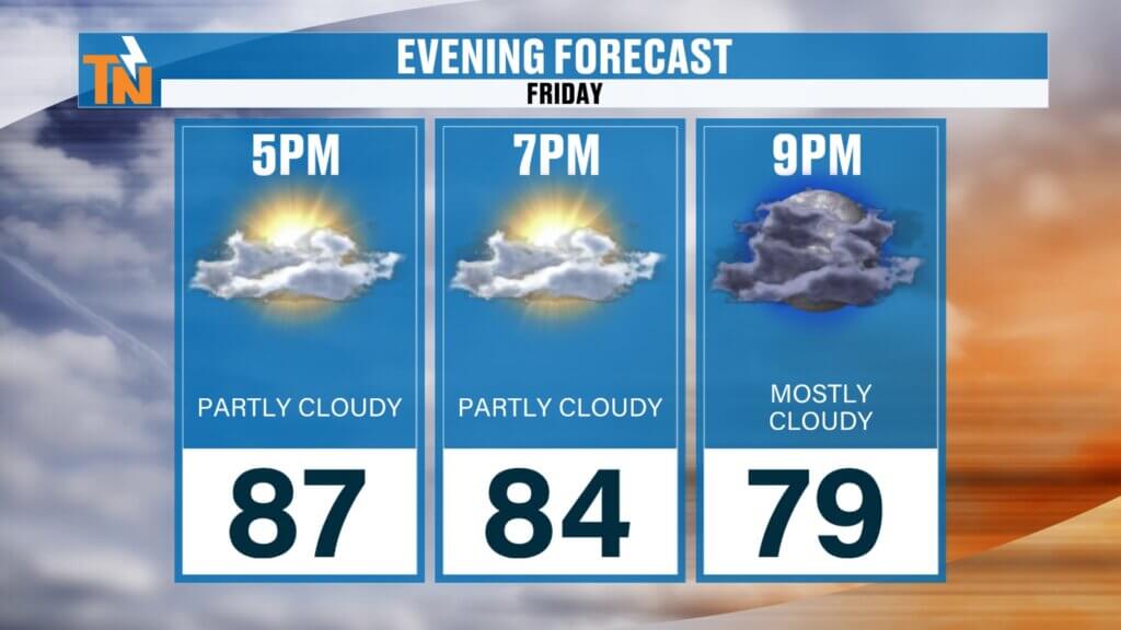
By Friday evening, most thunderstorms should begin winding down, leaving us with a warm and muggy but generally pleasant evening for outdoor plans.
Saturday: Better Chance for Storms
Our next upper-level disturbance arrives Saturday.
The morning should begin relatively quiet, but showers could begin entering the region by late morning before coverage increases during the afternoon.
Storm motion will take on more of a southwest-to-northeast trajectory as that disturbance crosses the Tennessee Valley.
This should provide a little more lift and a somewhat better opportunity for scattered showers and thunderstorms than we’ll have today.
But here’s the important part:
Saturday is NOT a washout.
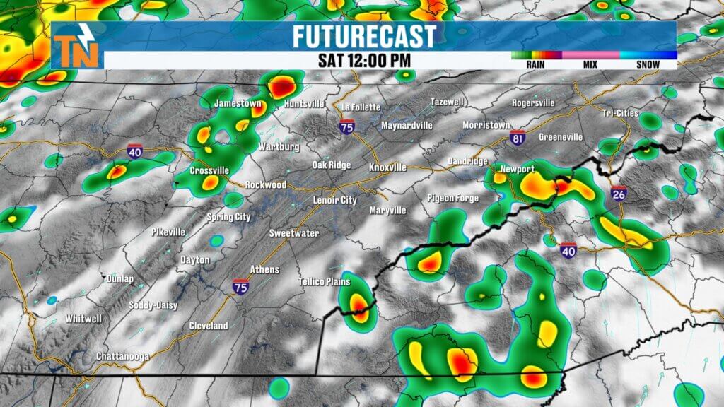
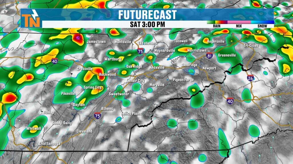
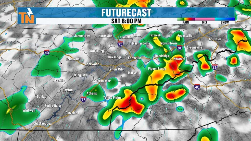
Some guidance remains relatively unimpressive with overall rainfall coverage. So if you have outdoor plans, don’t cancel them based solely on a rain percentage.
Check the forecast Saturday morning and keep the interactive radar handy.
Remember, a rain percentage doesn’t tell you timing, duration, intensity or rainfall totals.
Those details matter.
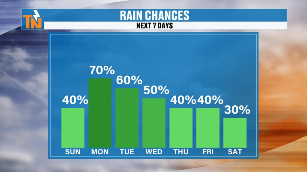
Sunday Looks Best
Once Saturday’s disturbance moves through, rain coverage should decrease considerably Sunday and Monday.
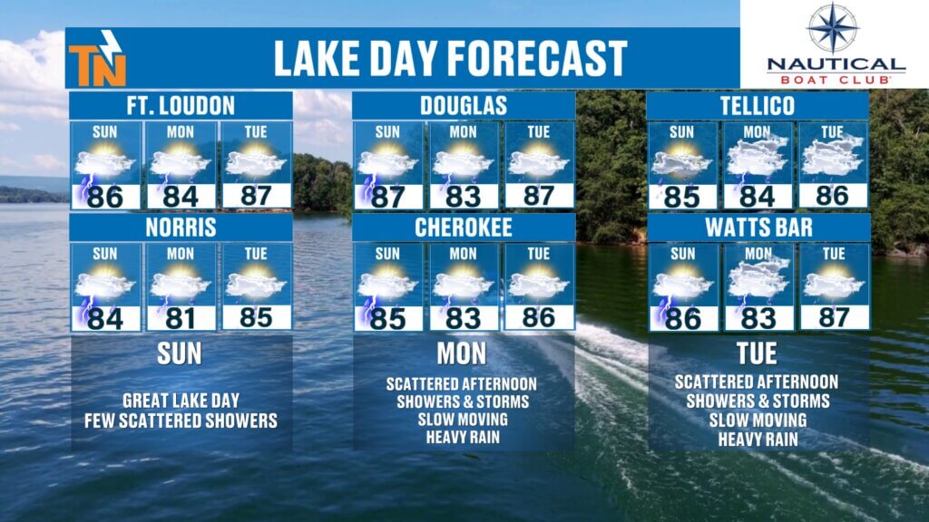
That makes Sunday the pick of the weekend, especially if you’re planning a lake day, pool day or other outdoor activities.
A stray summertime shower or storm can’t completely be ruled out, but overall coverage should be considerably lower.
Heat Builds Next Week
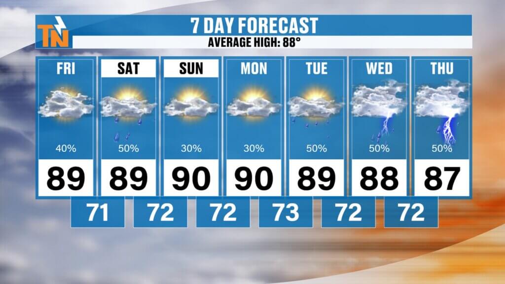
Temperatures won’t change much over the next several days.
The Central Valley remains in the upper 80s to lower 90s, while the Southern Valley will generally be a little hotter.
The Cumberland Plateau and higher elevations stay somewhat more comfortable with highs mainly in the 80s.
However, humidity remains high.
Heat index values should stay in the mid and upper 90s through the weekend before potentially climbing back into the lower 100s Monday and Tuesday.
Another upper-level trough may then begin digging into the eastern United States during the middle and latter portions of next week.
That could return us to a northwesterly flow pattern with additional disturbances capable of increasing our opportunities for showers and thunderstorms Wednesday through Friday.
Your Weekend Bottom Line
FRIDAY: Scattered afternoon storms. Not everyone gets rain. Locally heavy downpours possible.
SATURDAY: Better storm coverage as an upper-level disturbance moves through. Still not a washout.
SUNDAY: Best day of the weekend. Lower rain chances and more opportunities to enjoy the outdoors.
If you’re heading to Norris, Douglas, Cherokee, Fort Loudoun, Tellico, Watts Bar or any of our East Tennessee lakes this weekend, Sunday is your best bet. Today and Saturday are still workable—just keep an eye on the sky and radar.
Download the FREE eastTNweather app and allow location services and notifications so you can track storms with the interactive radar and receive weather information wherever you are.
And if you’re watching on YouTube, please Like, Share and Subscribe to the eastTNweather channel and turn on notifications so you never miss an update.
I’m Meteorologist Mike Witcher.
Have a fantastic Friday and a great weekend!
eastTNweather — Weather When You Want It.
High-Search Keywords
East Tennessee weather, Knoxville weather, Knoxville weekend forecast, East Tennessee weekend weather, Tennessee thunderstorms, Knoxville thunderstorms, East Tennessee rain chances, Saturday weather Knoxville, Sunday weather Knoxville, East Tennessee lake forecast, Norris Lake weather, Douglas Lake weather, East Tennessee radar, Mike Witcher, eastTNweather
Hashtags
#eastTNweather #TNwx #KnoxvilleWeather #EastTennessee #WeekendForecast #FridayForecast #SummerStorms #Thunderstorms #HeavyRain #FlashFlooding #Knoxville #SmokyMountains #CumberlandPlateau #LakeWeather #MikeWitcher