
Published: Tuesday, November 3, 2026 | By Meteorologist Mike Witcher | eastTNweather
Good morning, East Tennessee! I so do appreciate you checking in on this Tuesday, November 3rd.
Here’s the big story: we are dealing with a water-loaded atmosphere, and it’s headed our way.
Today is warm, with near record highs and increasing clouds.
Tomorrow is the main event. A storm system and a cold front move in with heavy rain, a risk for flash flooding, and a lot of wind, especially across the foothills and mountains.
Then the cooler air arrives behind it for the weekend. It’s kind of a roller coaster ride this week, so let’s walk through it.
Yesterday's Almanac
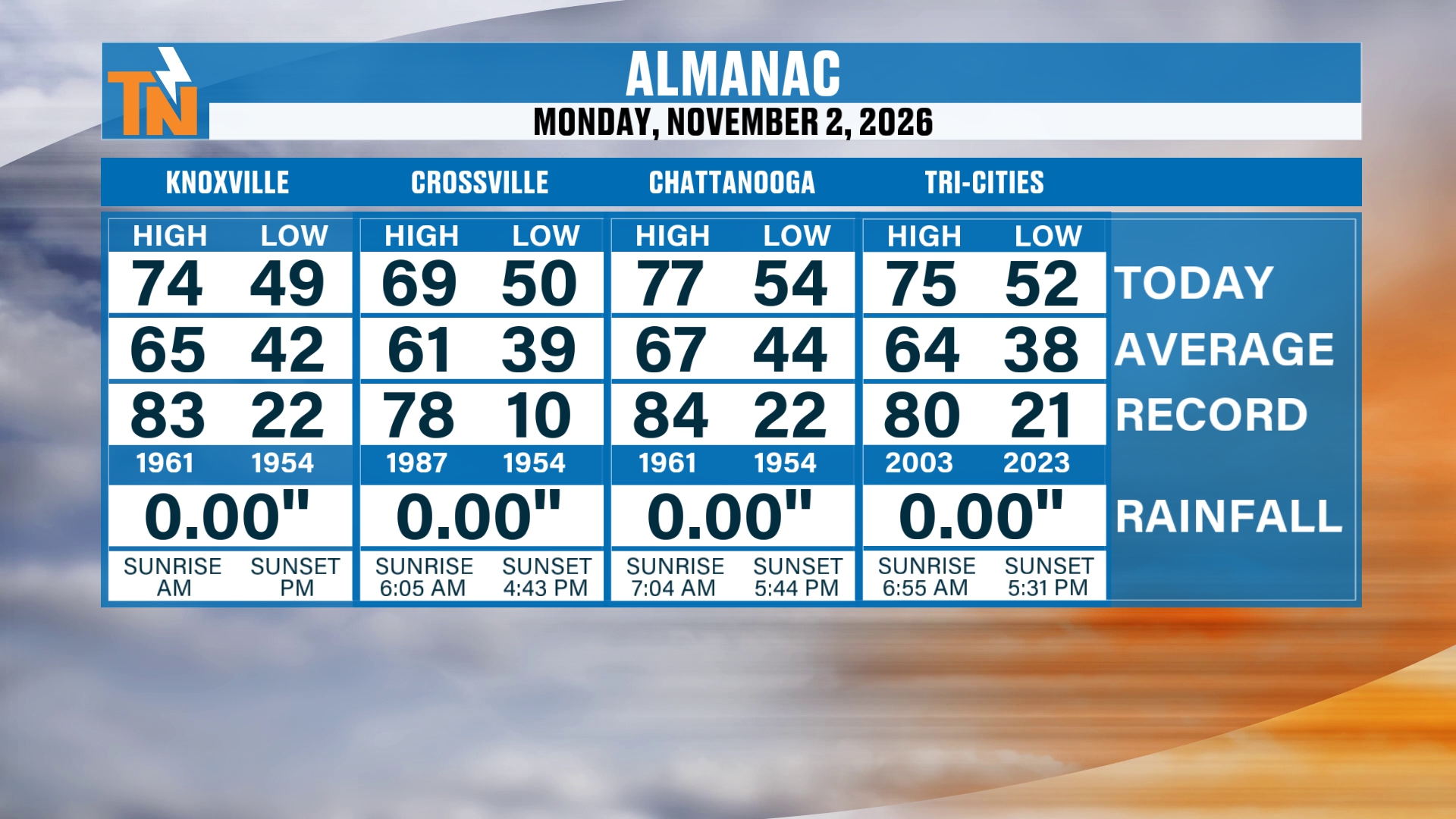
We had a warmer day yesterday. We were nearly 10 degrees above average, and we’re going to continue that trend today with near record highs.
Crossville made it to 69°.
Chattanooga hit 77°.
And the Tri-Cities area reached 75°.
Knoxville topped out at 74°, compared to an average high of 65° for this time of year.
Satellite and Radar: A Severe Risk Back to Our West
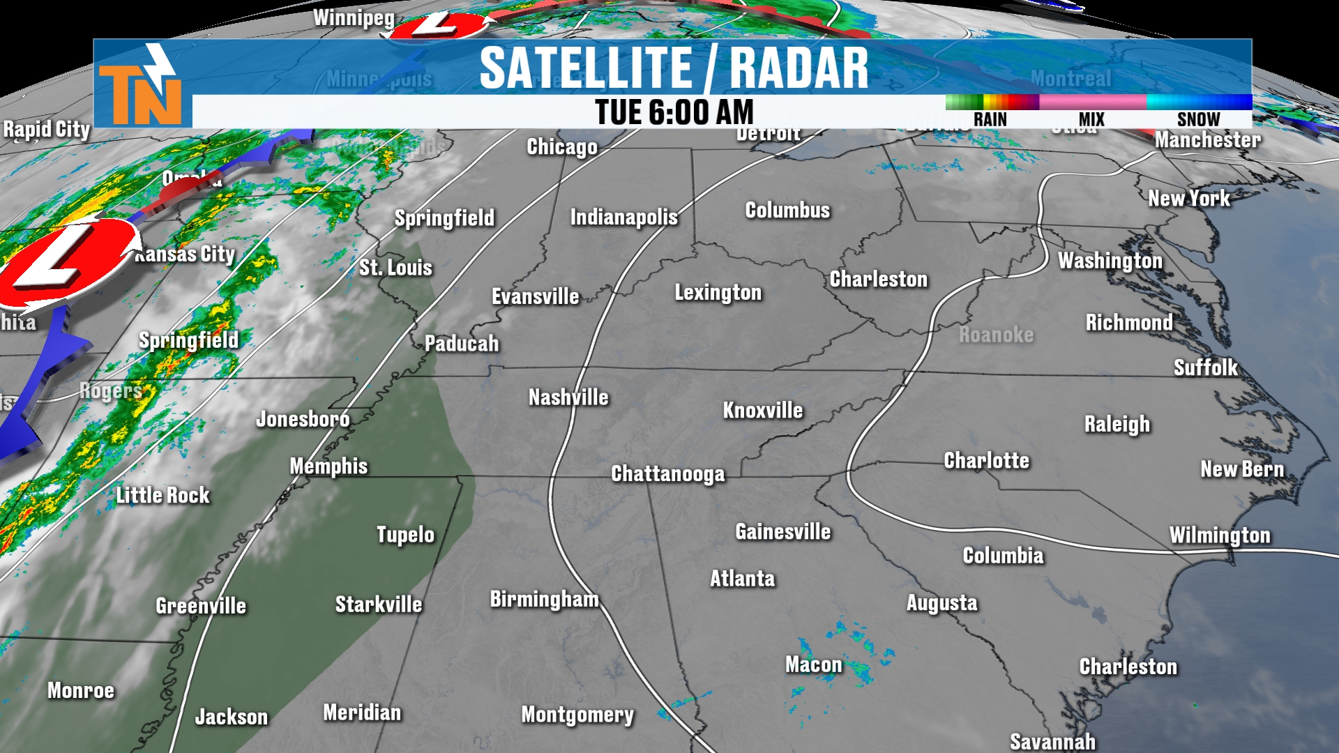
Here’s your satellite and radar to get the day started.
We’ve got a few clouds hanging out with us and a little bit of fog. But the main story is the storm system to our west.
That system is going to produce the potential for some strong to severe thunderstorms back along the Mississippi River Valley and into West Tennessee.
And that surge of moisture is going to continue to increase.
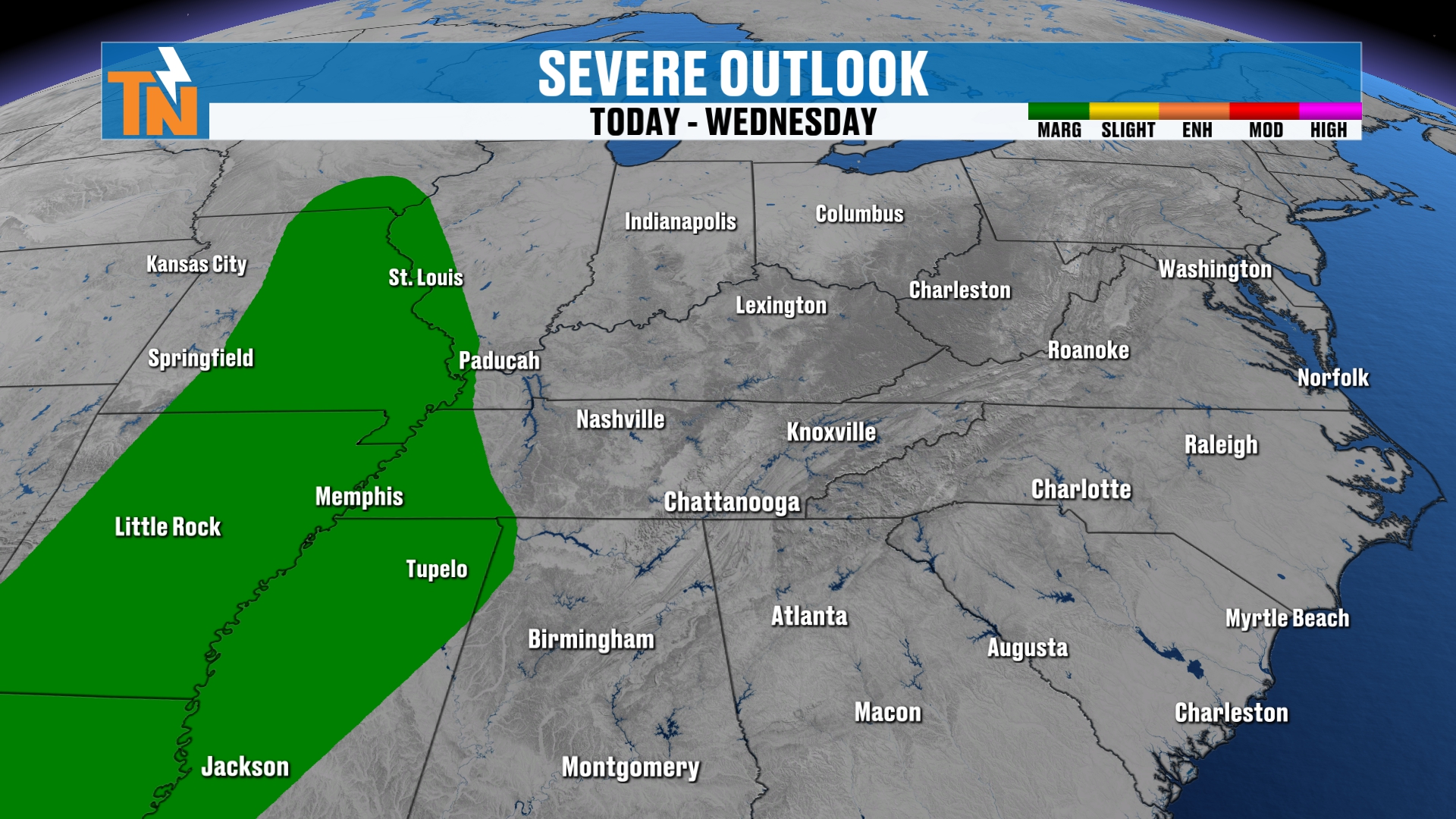
When you look at your risk level for severe weather today from the Storm Prediction Center, it includes places like St. Louis, Memphis, Tupelo, Little Rock and Jackson, Mississippi.
So that’s where the severe threat sits today. It’s not here, but it’s a big part of the story.
A Flood Risk Comes With It
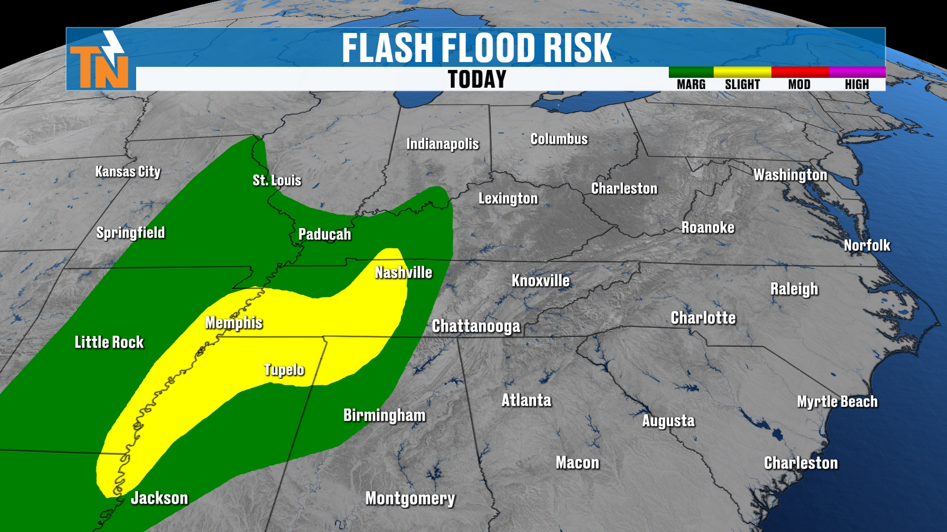
We also have a flood risk associated with this storm system.
We are looking at some heavy rain moving its way through the area. A big old push of warm Gulf water, or moisture rather, is going to be swinging into the region.
So the chance for flooding does exist from Nashville to Memphis. That’s where we have a level one and level two risk for some localized flooding and flash flooding concerns.
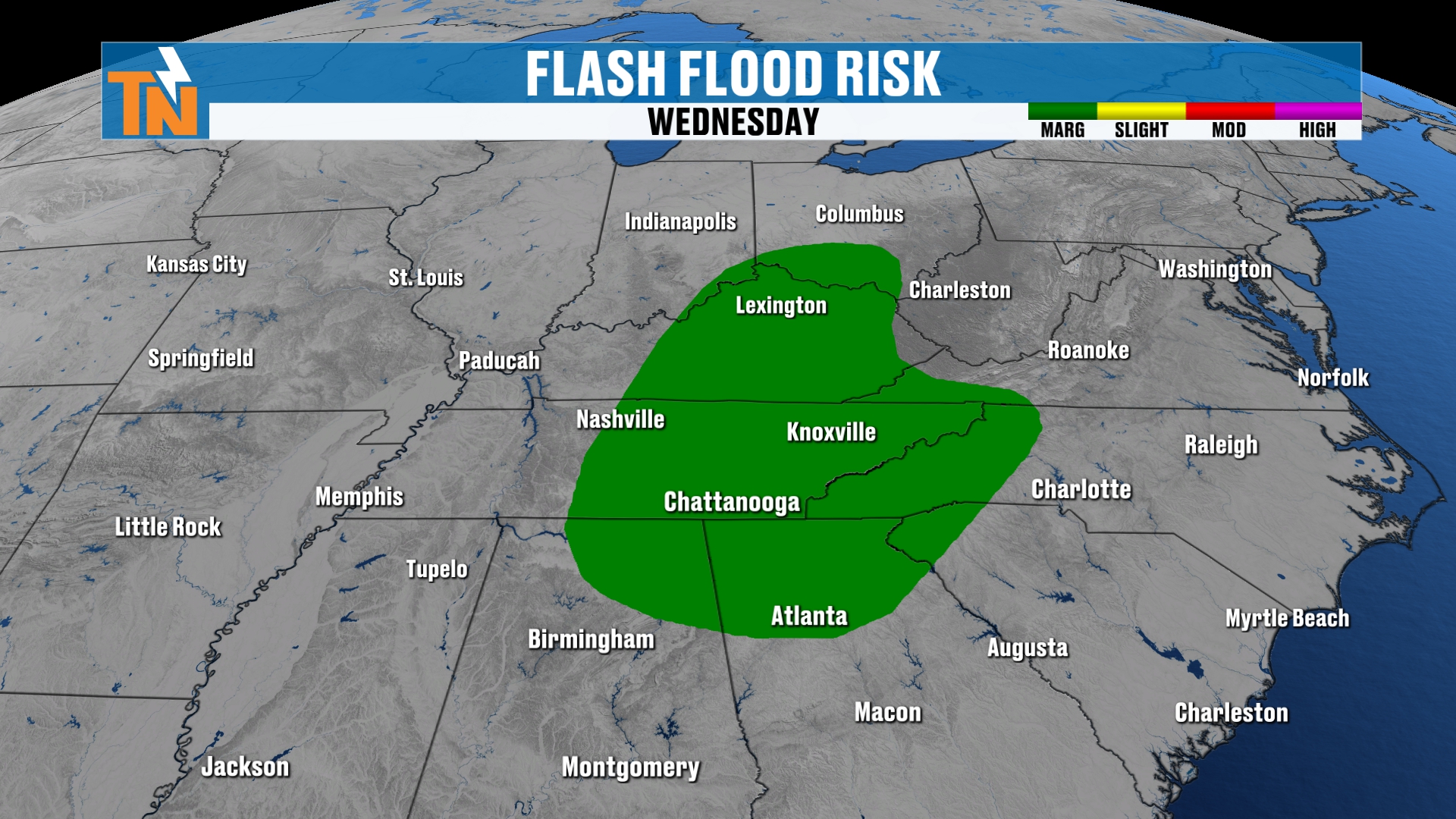
Then that risk level shifts over to East Tennessee and parts of Kentucky as we get into the day tomorrow. The Weather Prediction Center has issued a level one risk for flooding and flash flooding concerns.
It’s all associated with a big old surge of moisture.
A Water-Loaded Atmosphere
I mean it when I say water-loaded.
We’re talking anywhere from 200 to 300% of normal.
The average precipitable water value for the atmosphere this time of year is about half an inch. We’re going to be pushing about an inch and a half to an inch and three quarters.
That is a water-loaded atmosphere, and that’s why we’re watching the flooding potential so closely.
The Big Picture: Timing It Out
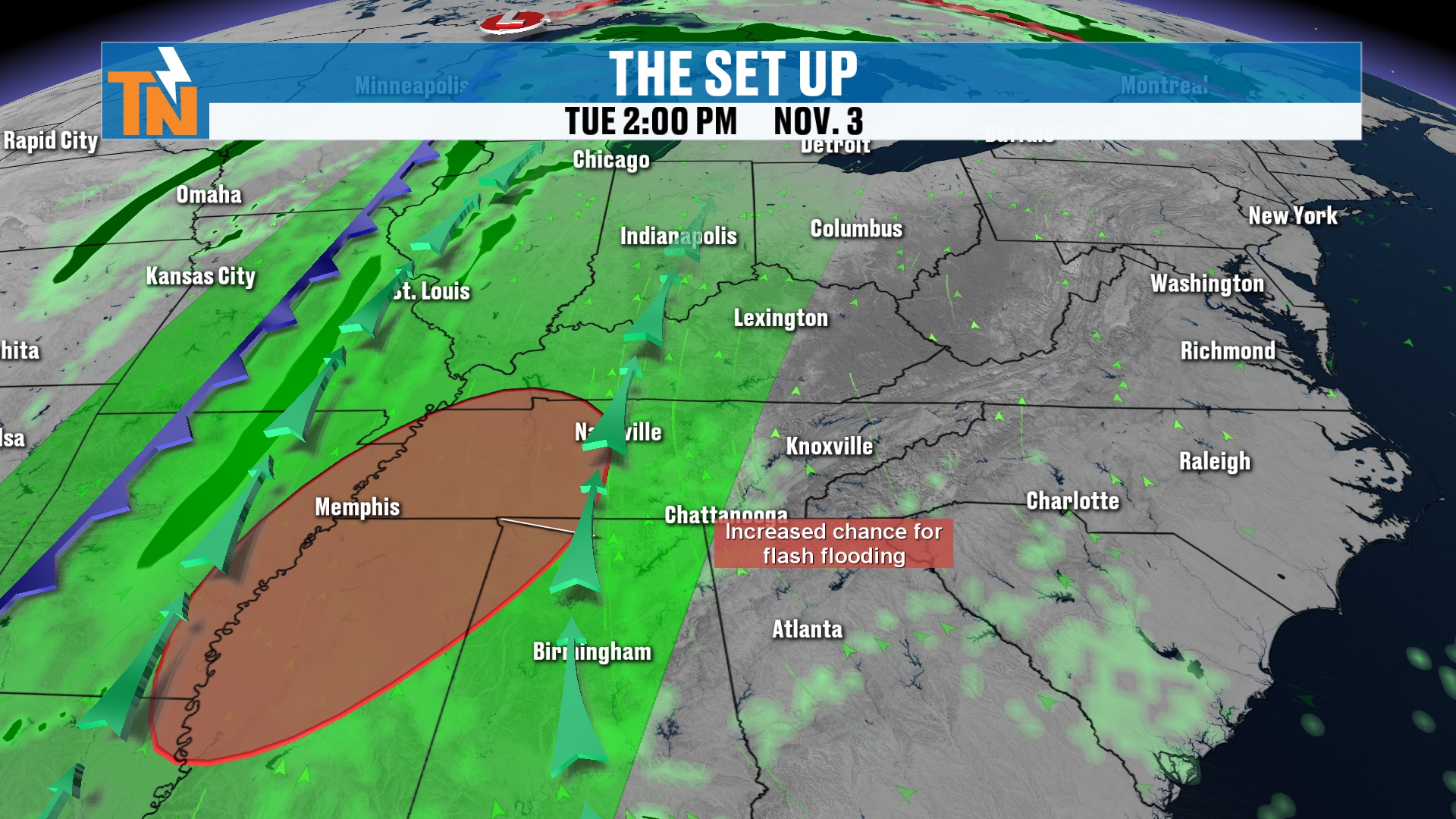
Let’s time it out for you. Here’s our futurecast.
We’ll bring things down to the local level and walk you through the details in just a second. But I want to show you the big picture pattern first.
This moisture surges into the area tonight and through the day tomorrow. Then it begins to exit as we get into Thursday and Friday.
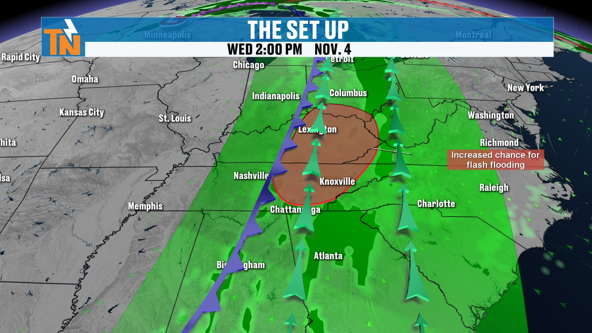
Watch that little wraparound moisture in the top left-hand side of your screen, around the low pressure system. That will likely swing into the area on Friday.
That’s likely to bring us mostly cloudy skies and maybe a little bit of light rain throughout the day on Friday, as that low pressure kind of sweeps its way through.
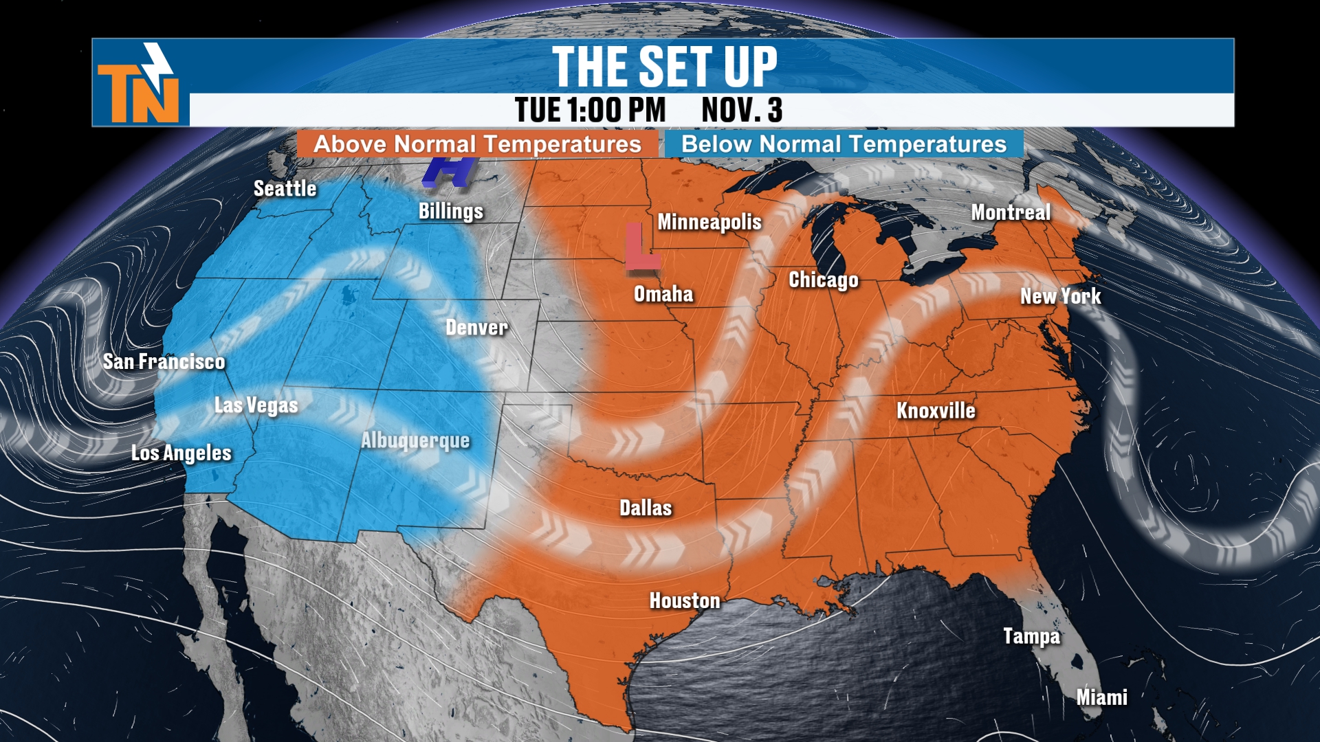
Troughing in the Middle, a Ridge on the East Coast
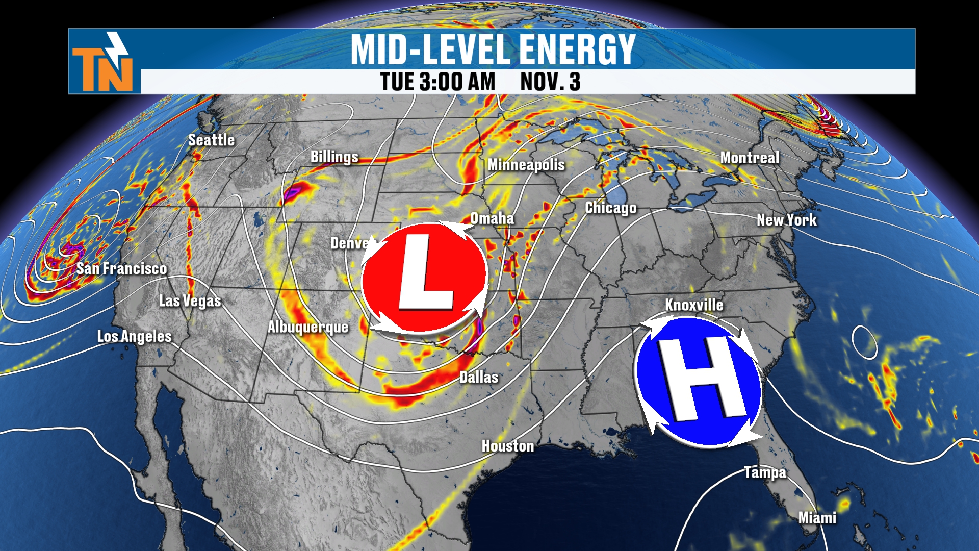
Here’s the big picture pattern.
We’ve got some troughing across the midsection of the country. That’s our next storm system.
But a big old ridge of high pressure dominates the eastern seaboard.
So not only are we talking about the risk for severe storms and locally heavy rainfall that could lead to flooding and flash flooding concerns, we’re also talking about the potential for some near record heat.
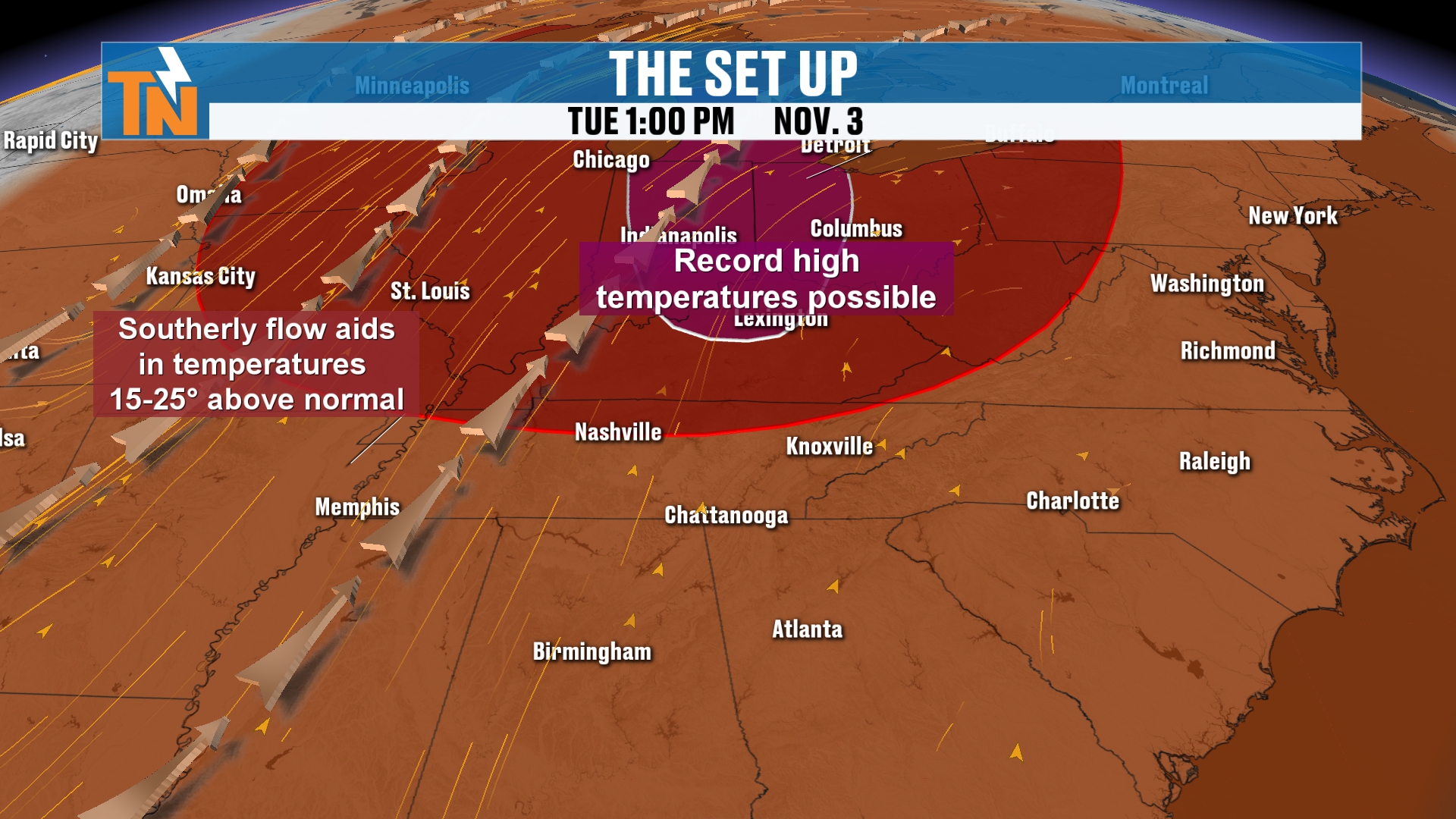
Most of that heat is going to be across the Ohio Valley throughout the day today.
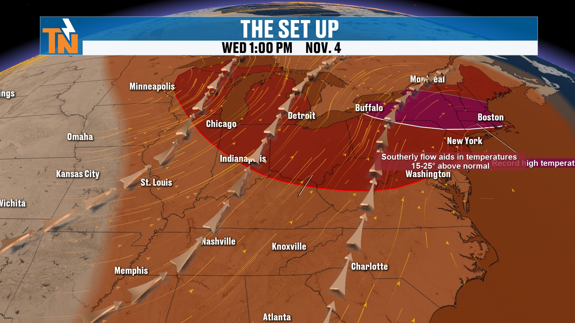
And then the northeast and the Great Lakes get it tomorrow.
We will continue here locally to stay above average, thanks to this ridge of high pressure that’s starting to build its way in.
But our storm system, the one we’re talking about throughout the day tomorrow and into Thursday, is back off to our west. A lot of energy in the mid-levels of the atmosphere is going to continue to slide through.
Rain Chances Are Elevated
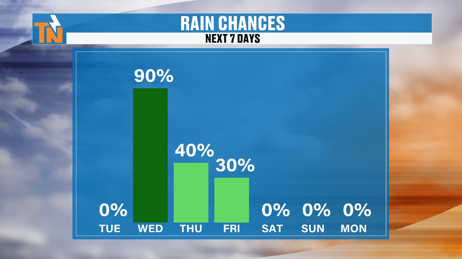
So we have elevated those rain chances for tomorrow.
It’s a 0% chance today. But we’ll start to see some rain showers increasing overnight tonight.
Everybody’s pretty much getting wet throughout the day tomorrow. And there’s a flood concern, because some areas could pick up anywhere from one to two inches of rainfall.
Then we’ll kind of tailor those rain chances down as we get into Thursday and Friday.
The weekend should be on the dry side, with sunshine and a mix of sun and clouds. But definitely some cooler temperatures.
Today's Temperatures: Warmer Than Yesterday
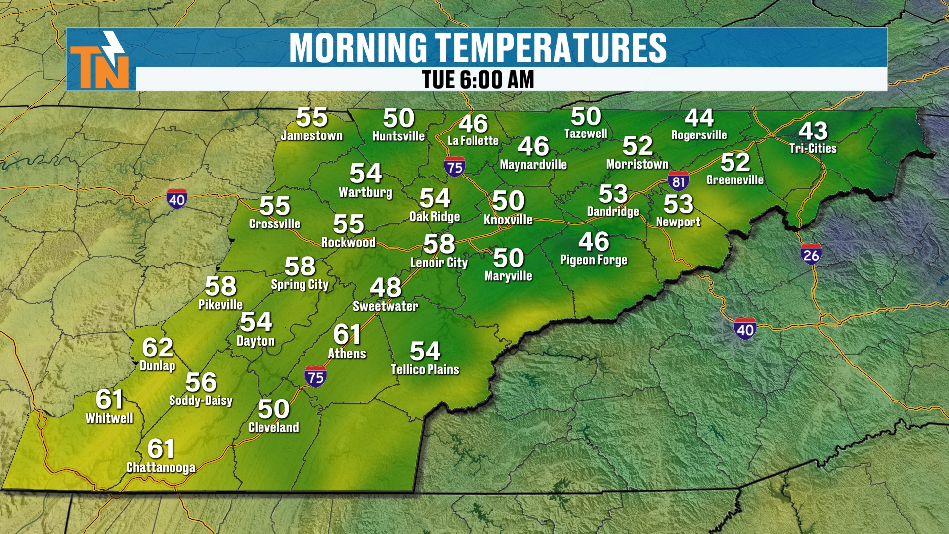
All right, let’s talk about it this morning.
We start off with temperatures in the 40s and 50s.
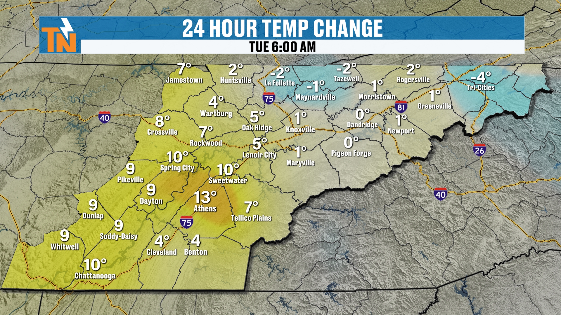
Temps this morning are trending about 5 to 10 degrees warmer in most locations than what we were yesterday.
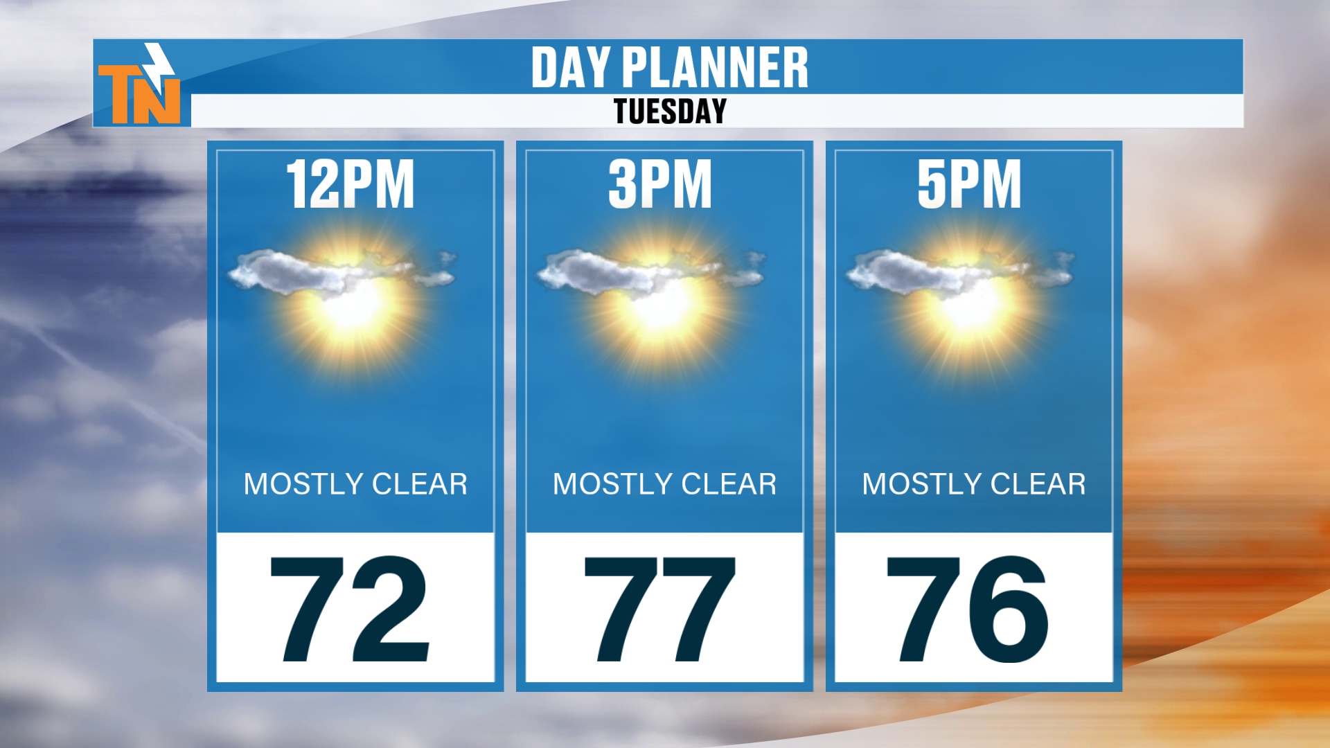
Lunchtime temperatures will be in the low 70s.
By the time the kids head home from school, we’re going to be in the mid to upper 70s.
Again, that’s warmer than what we were yesterday. Near record highs.
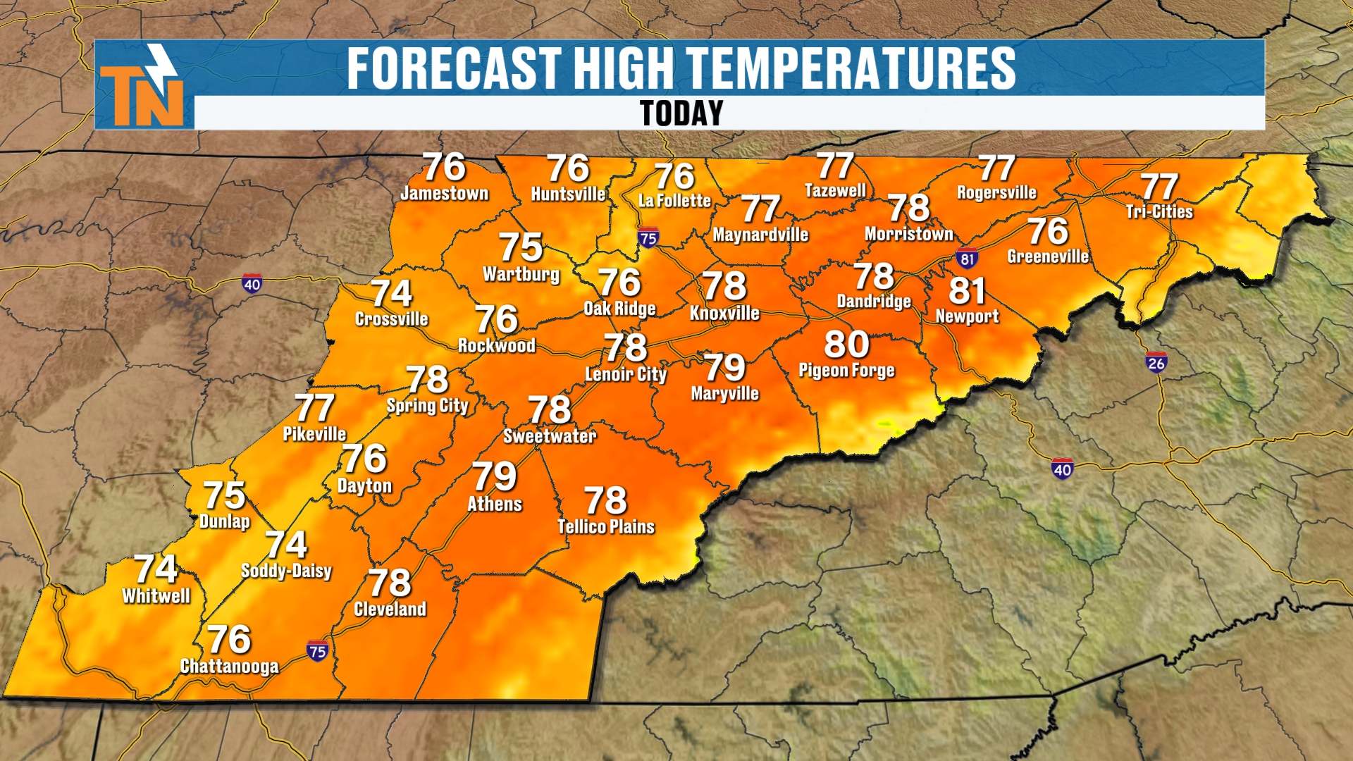
And again, we’re looking at temps to trend well above average by nearly 10 to nearly 15 degrees.
Wind Is on the Increase
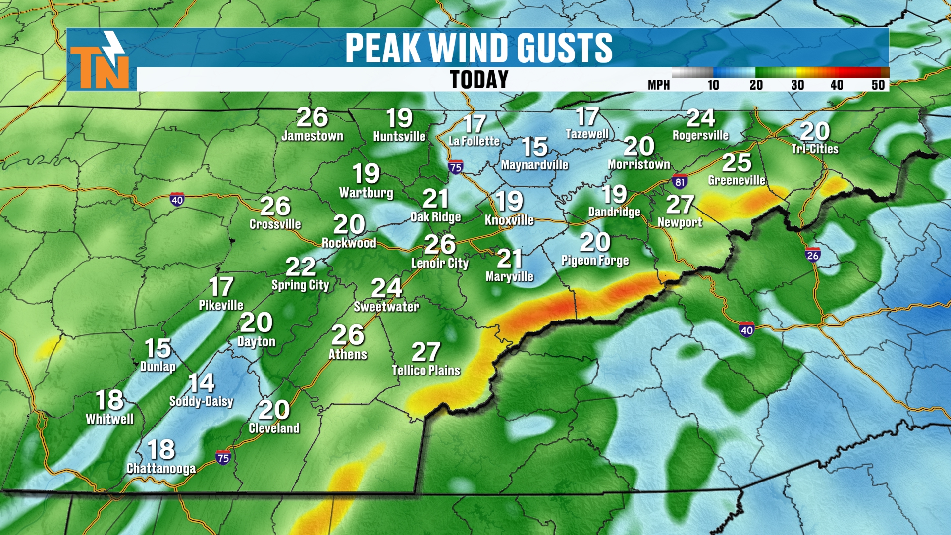
Just like the last couple of days, the highest peaks of the Smokies will experience some of the strongest winds. It’s a little bit on the breezier side here in the valley locations, too.
But as that cold front approaches, the wind will continue to increase across the area.
Tonight's Evening Forecast
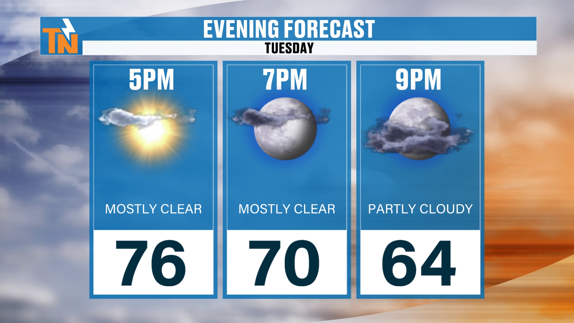
As we get into the evening hours, the sun’s setting around 7:00.
Temperatures will be right around 70 by 7, dropping down to 64 by 9.
Futurecast: Rain Arrives Overnight
Now here’s your futurecast for overnight tonight.
We’re going to see increasing clouds throughout the afternoon and evening hours. Mostly cloudy by this evening.
Rain showers will be increasing overnight tonight.
You could have some wet roads and some soggy conditions to get your Wednesday morning started, especially between Nashville and the Crossville area.
Rainfall amounts overnight tonight will be the heaviest along the Cumberland Plateau.
We probably won’t see a whole lot across the eastern sections of East Tennessee. If you’re taking I-75 as the corridor, east of I-75 is probably going to be on the drier side, at least to get your Wednesday started.
But it’s not going to stay that way.
Wednesday: Scattered Showers, Then the Cold Front
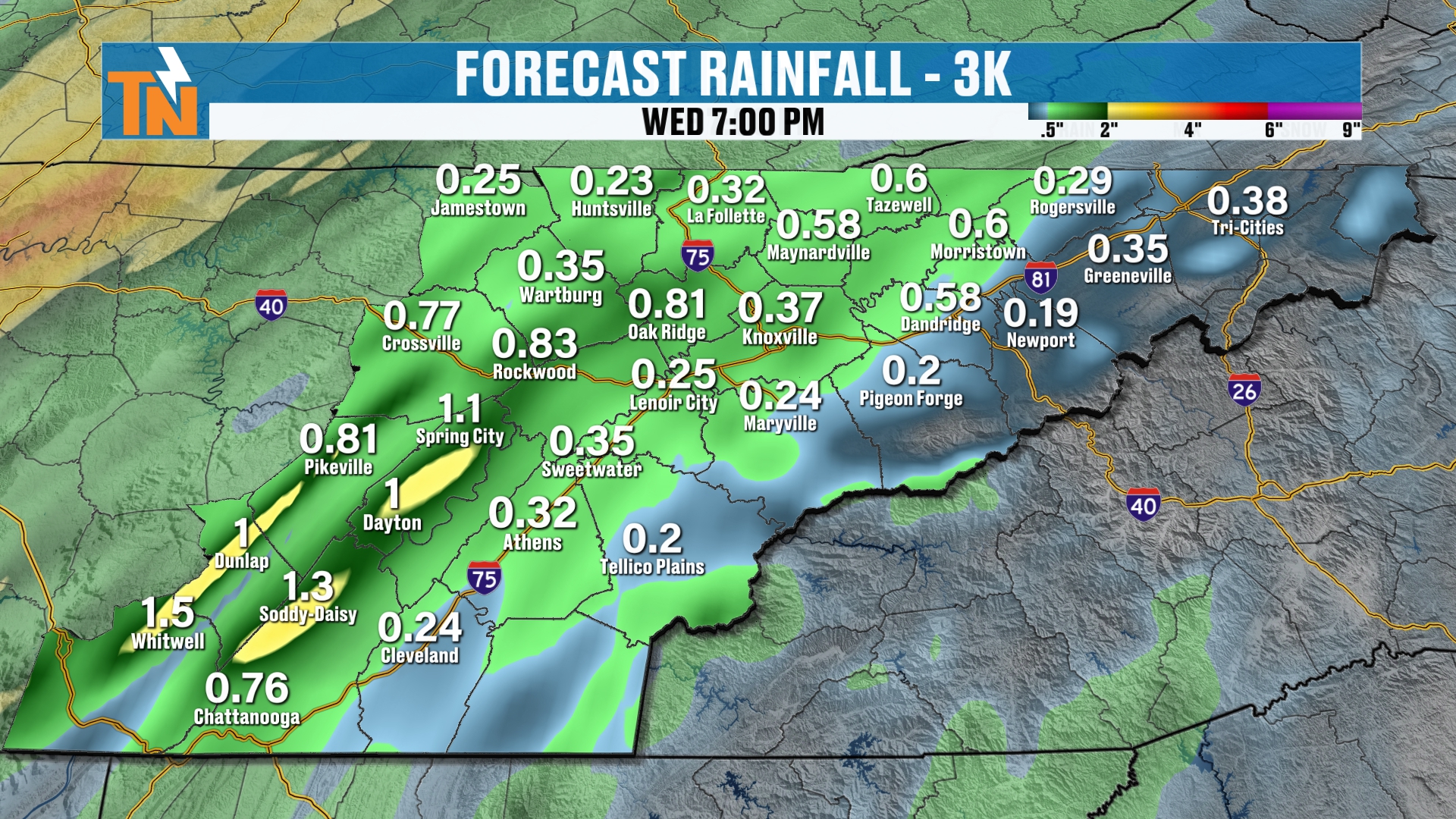
As we pick up our timeline on Wednesday, you can see how the model guidance is picking up on some scattered showers.
Then, as we get into the afternoon, that’s when the cold front starts to slide into the area.
That’s going to bring us increasing rain chances as we get into the afternoon and evening.
A couple of rumbles of thunder can’t be ruled out. But we don’t have a lot of instability in the atmosphere.
What we do have is a lot of wind and a lot of moisture to produce some locally heavy rain.
When you look at your rainfall forecast, most areas are probably going to pick up about three quarters of an inch to an inch and a half of rain.
Some may get a little bit more. Some a little bit less.
And I think where we get a little bit less rain is going to be across the foothills and mountain counties.
We’re going to once again have a rain shadow effect taking place across the western side of the Smokies, thanks to a downsloping wind.
Wind Advisory Potential in the Mountains
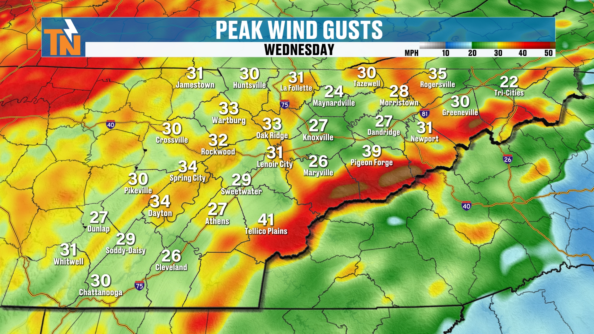
We’ve got a lot of wind, and the National Weather Service is talking about the potential for a wind advisory across the mountains of East Tennessee.
That’s where the strongest winds are going to be occurring.
In the valley locations, we’re going to have winds gusting to about 25 to 30 mph. That puts us at wind advisory criteria in the lower elevations. But it’s the higher elevations that are likely to see a wind advisory.
As of right now, it has not been issued. Keep checking back.
Cooler, Drier Air Settles In
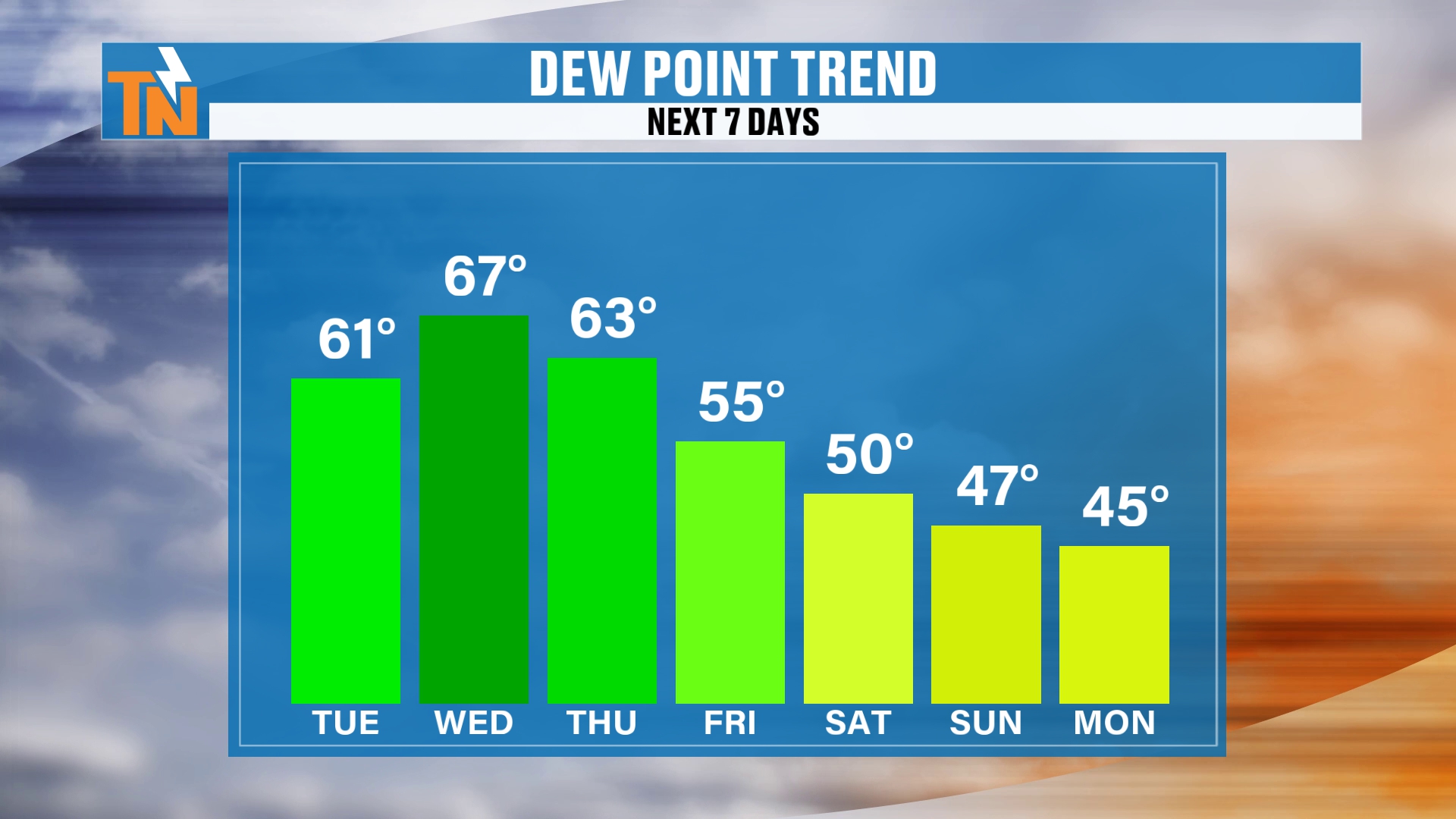
The dew points behind this system are going to start to fall.
That’s going to allow some cooler, drier air to settle in.
And you’re going to see shots of colder air when we pick up our timeline on Thursday night.
The colder air is going to be locked up across the Great Lakes and into Canada. But watch as this cooler air starts to settle south and southeast as we get into Saturday and Sunday.
That’s going to bring our temperatures down to below average.
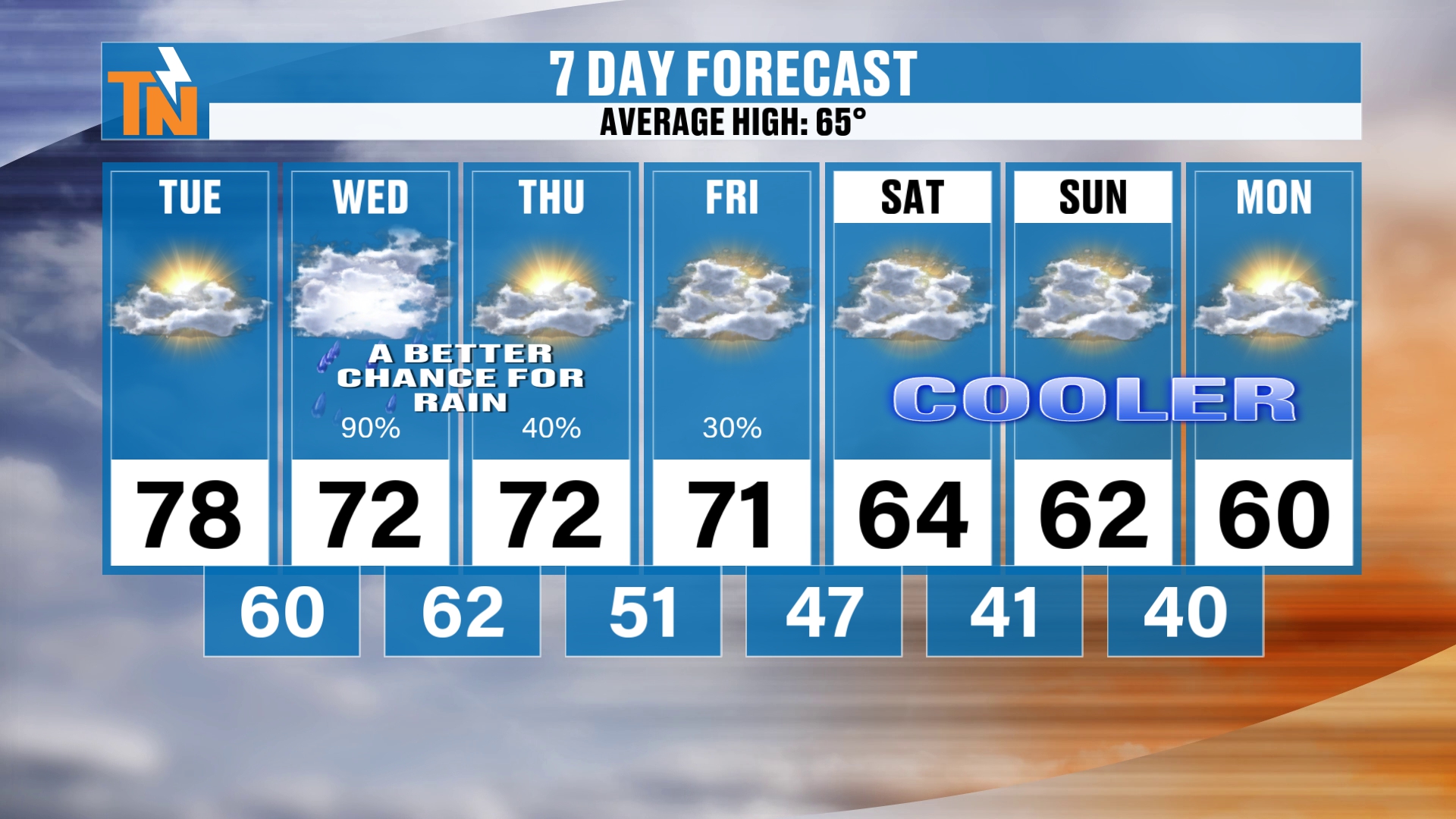
So yeah, cooler weather is on the way.
Saturday we’re at 64.
Sunday we’re at 62.
And Monday we’re going to have high temperatures in the 50s and 60s, with morning lows probably in the 30s and low 40s.
So we are looking at some chillier, more November-type weather returning to the area.
Climate Prediction Center Outlooks
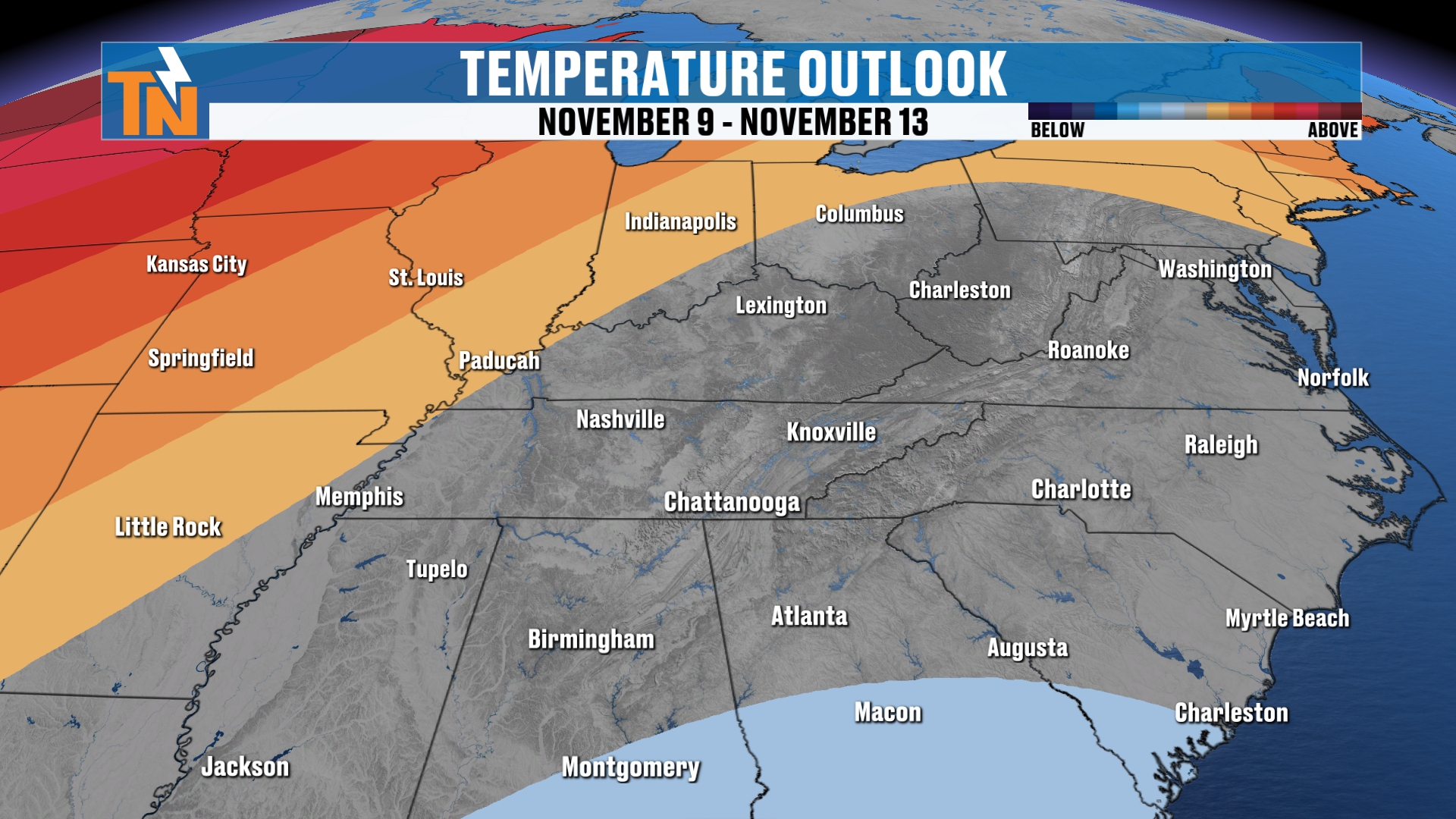
For the Climate Prediction Center, we’re going to stay about average on your 6 to 10 day outlook, although I think we’re going to be trending below average.
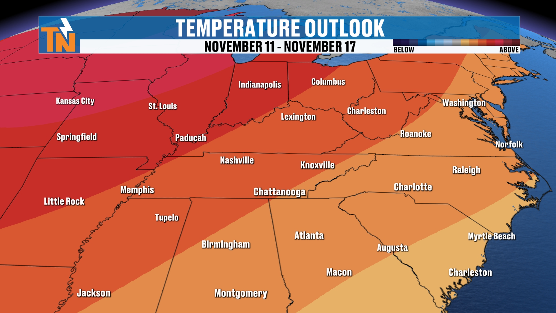
And in your 8 to 14 day outlook, well, the Climate Prediction Center is bringing back a little bit of warmth to the area.
So it’s kind of a little bit of a roller coaster ride heading our way this week.
Bottom Line
TUESDAY: Warm sunshine with increasing clouds through the day. Near record highs, 10 to 15 degrees above average. Lunchtime in the low 70s, mid to upper 70s by the time school lets out. About 70 at 7 PM, 64 by 9 PM. Rain showers increasing overnight. Winds increasing as the cold front approaches.
WEDNESDAY: Wet roads and soggy conditions to start, especially between Nashville and the Crossville area, with the east side of I-75 drier early. Scattered showers, then the cold front brings increasing rain chances in the afternoon and evening. Most areas pick up about three quarters of an inch to an inch and a half. A rumble of thunder is possible. Less rain in the foothills and mountains, where the wind will be cranking. Valley gusts around 25 to 30 mph. A level one flood risk for flash flooding.
THURSDAY: Rain chances tailor down. Dew points fall and cooler, drier air starts to settle in.
FRIDAY: Mostly cloudy and maybe a little light rain as wraparound moisture swings through.
SATURDAY: Dry and cooler. A mix of sun and clouds, high near 64.
SUNDAY: Dry. A high of about 62.
MONDAY: Highs in the 50s and 60s, with morning lows in the 30s and low 40s.
So to recap: warm sunshine with increasing clouds today, about 10 to 15 degrees above average with near record highs. The frontal boundary and storm system move in tomorrow, bringing elevated rain chances. Everybody pretty much has a good shot, with less rain across the foothills and mountains. The wind is going to be cranking up there. And then behind the cold front, we’ll see those temperatures come on down.
Make sure you download the FREE eastTNweather app from your app store, and for your smart TVs on Roku or Amazon Fire. You can also just search for East Tennessee Weather on the YouTube icon on your smart TV. Have it playing in the background. It’s a family-friendly way to get your weather information every day. I run the first and only 24-hour weather channel for us here in East Tennessee.
And if you’re watching on YouTube, don’t forget to LIKE, SHARE, SUBSCRIBE and hit the bell so you’re notified of every weather update.
If you stuck around this long, let me know where you’re watching from. I’d like to know exactly who’s watching. And if you think there’s something else I should add to these videos, let me know in the comments below. I’ll try to answer as many questions as I can.
Catch up on all of my recent daily forecasts anytime.
I’m Meteorologist Mike Witcher. Have a great Tuesday!
eastTNweather — Weather When You Want It.