
Happy Friday, everybody.
I sure hope you have a great day today and an even better weekend.
And I’m going to tell you right now — today, tomorrow, and even most of Sunday are looking fantastic.
But…
There is a bump in the road.
And that bump arrives late Sunday into Monday and Tuesday with another round of showers, thunderstorms, and potentially some heavy rainfall.
Let’s break it all down.
Friday Starts the Weekend Improvement
After dealing with tropical moisture and scattered storms yesterday, things are finally improving.
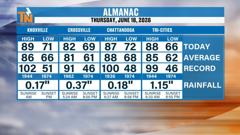
Thursday brought temperatures into the low, mid, and upper 80s across East Tennessee. Knoxville officially hit 89° at the airport while picking up 0.17 inches of rainfall.
Some areas did much better.
The Tri-Cities picked up over an inch of rainfall in spots.
Now that the remnants of Tropical Storm Arthur continue to pull away, we’re beginning to dry things out.
And you’re going to notice it.

Humidity Drops Today Across East Tennessee
This is the best part of today’s forecast.
Dew points this morning are still elevated in the upper 60s and lower 70s, but that dry air starts filtering in quickly as the day goes on.
By this evening:
- Dew points drop into the low 60s
- Humidity becomes much more comfortable
- The air feels cleaner and less sticky
For mid-June in East Tennessee?
That’s about as good as it gets.
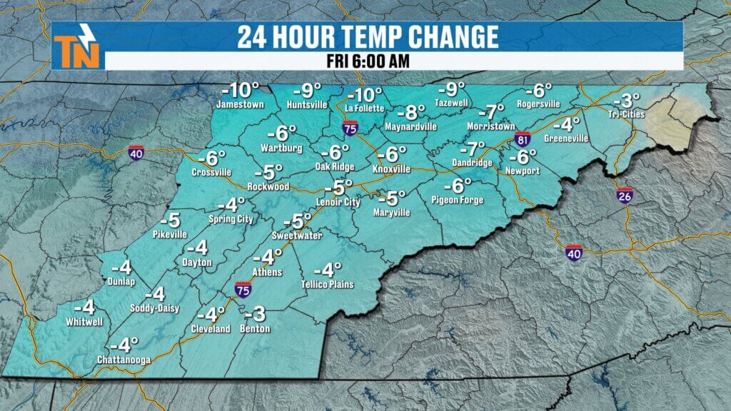
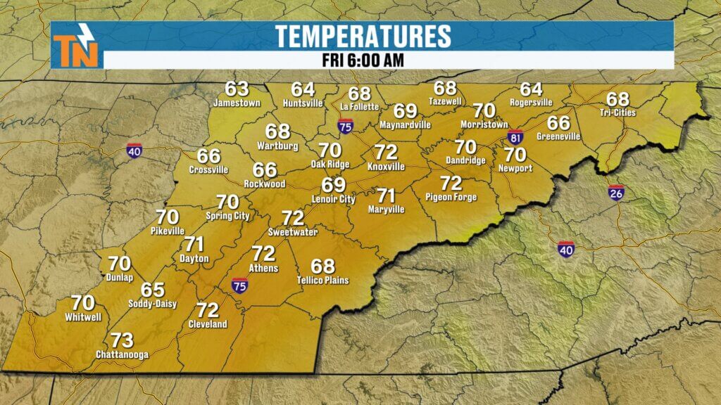
Friday Forecast: Clouds Early, Sunshine Returns
We’re starting off with some leftover cloud cover this morning, but those clouds will gradually clear out.
As high pressure builds in from the north and northwest:
- Sunshine returns
- Skies clear out
- Humidity drops
- Temperatures stay comfortable
Forecast highs today:
- Low to mid 80s
- Slightly below average
- Very little heat index
It’s a fantastic Friday setup.
Friday Evening Looks Excellent
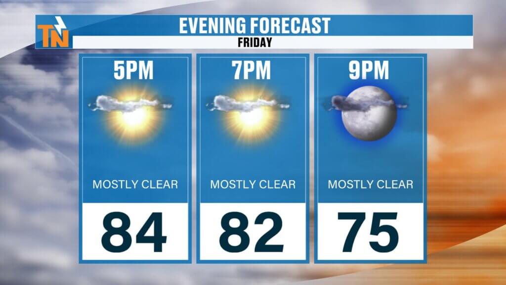
By tonight, the drier air really settles in.
By 7 to 8 PM:
- Temperatures in the low 80s
- Lower humidity
- Light breeze
- Mostly clear skies
That means ideal weather for:
- Friday night football
- Patio dinners
- Outdoor concerts
- Neighborhood walks
- Summer cookouts
It’s going to feel amazing.
Saturday Looks Like the Best Day of the Weekend
Saturday may be the winner.
Expect:
- Plenty of sunshine
- Lower humidity
- Warm temperatures
- Comfortable mornings
- Great evening weather
If you’re headed:
- To the lake
- Poolside
- Hiking
- Boating
- Yard work
Saturday is your day.
And yes — with the lower humidity, if you jump in the water, it’ll feel chilly when you get out.
That’s how good the air is going to feel.
Sunday Starts Nice, But Changes Late
Sunday still looks good for much of the day.
But humidity starts increasing.
That’s your first signal.
By late afternoon into Sunday night:
- Clouds increase
- Moisture surges back in
- Storm chances begin climbing
Not a washout.
But the setup starts changing.
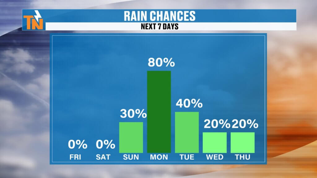
Storms Return Monday and Tuesday
This is the next weather maker.
A new upper-level disturbance currently over the Pacific Northwest will track eastward and tap into increasing Gulf moisture.
That system will bring:
- Showers
- Thunderstorms
- Heavy rainfall
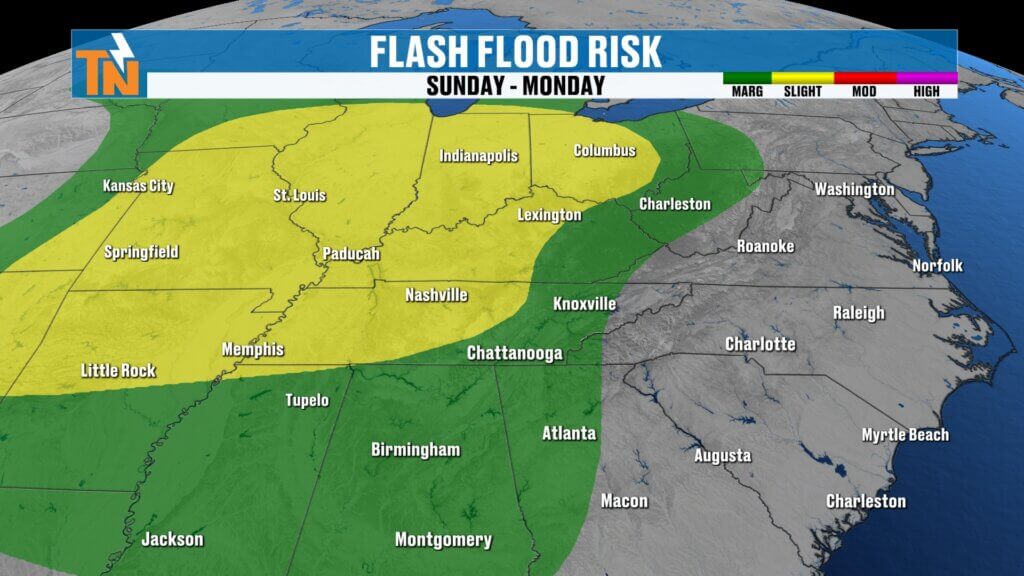
- Localized flooding concerns
The Weather Prediction Center has already outlined a Level 1 and Level 2 flooding risk for Sunday into Monday.
That tells us:
- Moisture will be abundant
- Rainfall could be efficient
- Some storms may dump heavy rain quickly
Severe Weather Risk Next Week
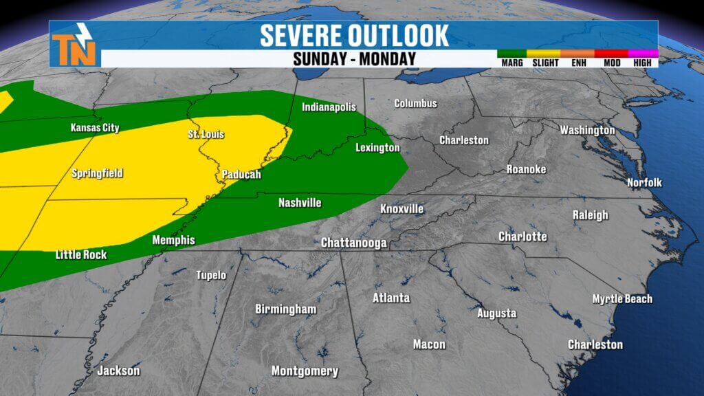
The Storm Prediction Center is also clipping parts of East Tennessee — mainly the northwestern counties — with a severe weather risk.
Main threats:
- Damaging winds
- Heavy rainfall
- Frequent lightning
This will be something we’ll continue to fine-tune over the weekend.
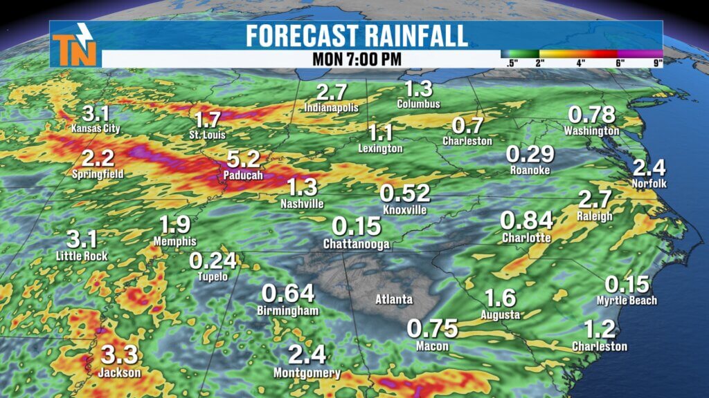
Rainfall Totals Could Add Up
Current projections through early next week:
- 1 to 2 inches possible area-wide
- Locally higher amounts possible
- Heaviest rain likely north and west of East Tennessee
This won’t all come at once.
But multiple rounds of storms could produce healthy rainfall totals.
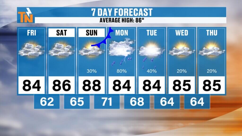
East Tennessee 7-Day Forecast
Friday
Morning clouds, afternoon sunshine
Less humid
High: 84°
Saturday
Sunny and beautiful
Low humidity
High: 86°
Sunday
Warm, increasing humidity
Late storms possible
High: 87°
Monday
Showers and thunderstorms
Heavy rain possible
High: 84°
Tuesday
Storms continue
Localized flooding possible
High: 84°
Wednesday
Scattered storms, humid
High: 85°
Thursday
Warm and muggy
Spotty storms
High: 86°
Bottom Line
The weekend forecast breaks down like this:
Friday: Beautiful
Saturday: Best day
Sunday: Good most of the day
Monday-Tuesday: Stormy and wetter
So if you’ve got outdoor plans…
Prioritize Friday and Saturday.
Those are your premium weather days.
And as always, keep checking in with the East Tennessee Weather app for radar, alerts, and daily forecast updates.
Whether you’re on your phone, Roku, Amazon Fire, or YouTube — it’s your best weather tool.
And yes… if you Google “best weather app for East Tennessee,” East Tennessee Weather pops right up.
Not bad.
Have a great Friday, enjoy the weekend, and go USA.