
Wednesday Forecast | A Beautiful Warm-Up and a Great Weekend Ahead
Good morning and happy Wednesday, everybody! I sure hope you’re having a great start to your day. Before we dive into what’s shaping up to be another nice East Tennessee forecast, it wouldn’t be Wednesday without a quick good morning to Ed Up. Wait for it… there he is! Bam. Just like that, we’re sliding […]
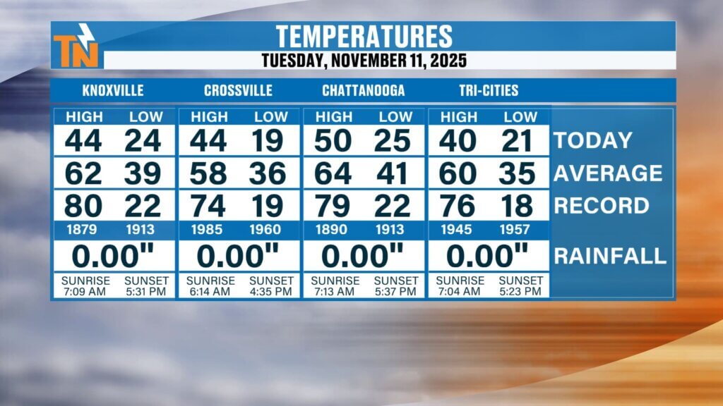
Tuesday Forecast | Bitter Cold Morning, But a Big Warm-Up Ahead
Good morning and happy Tuesday, everyone! It’s another cold, raw winter morning across East Tennessee. Temperatures are running 5 to nearly 10 degrees colder than yesterday, and it feels every bit like it. We’re waking up to teens and 20s across the region — 18° in Scott County, 25° in Loudon County, 27° in Chattanooga […]
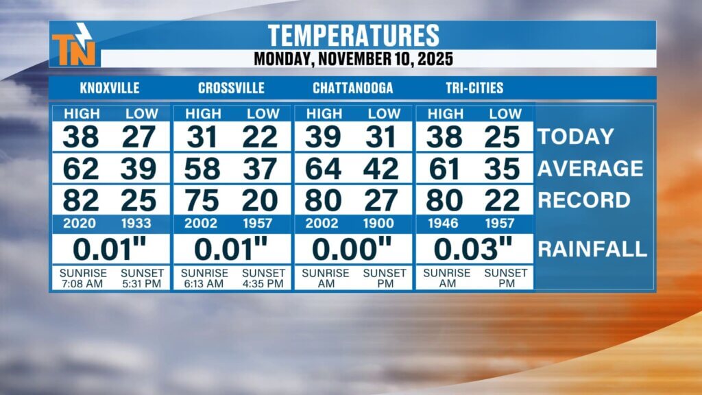
Monday Forecast | Snow Showers, Cold Blast & Brutal Wind Chills
Good morning and happy Monday, everyone! After some fresh snow overnight, it’s a cold, raw, heavy-coat kind of day around East Tennessee. We’re waking up to scattered snow showers, biting wind, and the coldest air of the season so far — and the day’s just getting started. The SetupWhile most of East Tennessee hasn’t seen […]
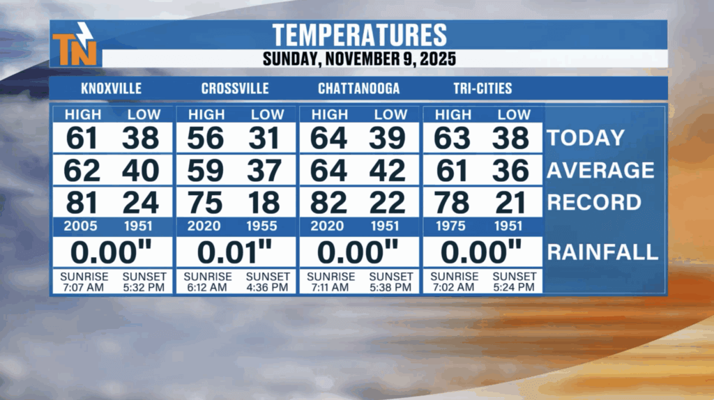
Sunday Forecast | Major Winter Storm Targets the Smokies — First Big Taste of Winter for East Tennessee
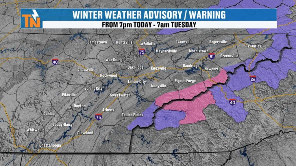
Good morning and happy Sunday, everyone! Thanks for checking in — we’ve got a major winter storm developing for the mountains of East Tennessee, and this one’s going to bring our first true blast of Arctic air and significant mountain snow. This system marks the start of a very active, cold, winter-like pattern that will […]
Saturday Forecast | Big Pattern Flip: Arctic Shot & First Snowflakes
Quick Take Dense fog advisory until 10 AM—slow down and use low beams. Mild today: 60s to low 70s, light wind, increasing high clouds. Big change Sunday: temps fall late day, gusty NW winds, rain changing to snow (mountains first). This MorningPatchy dense fog from last night’s rain. It thins 10 AM–noon. We start in […]
Friday Forecast | Two Cold Fronts, Then a Winter Preview
The SetupTwo cold fronts are lining up. The first arrives this evening with showers and a few thunderstorms. The second pushes through Sunday and drags in a much colder Canadian air mass. Severe RiskSPC keeps a Level 1 (Marginal) risk mainly along the Cumberland Plateau. Damaging wind is the primary threat; pea-size hail is possible […]
A Beautiful Thursday Before Storms and a Major Weekend Cool Down
Good morning and happy Thursday, everyone! High pressure is in control today, settling in behind yesterday’s cold front and bringing us abundant sunshine across East Tennessee. Enjoy it while it lasts — because we’ve got another cold front on the way, and this one will pack more of a punch. We start the morning in […]
Breezy Today, Weekend Rain, and a Possible First Taste of Winter Next Week
Good morning and happy Wednesday, everyone — happy hump day! We’ve got one of three cold fronts heading our way over the next seven days, so buckle up for a changing pattern across East Tennessee. This morning starts off mild, with temperatures in the 40s and 50s — a noticeable improvement from the frosty mornings […]
Fog, Frost, and a Big Cool Down Coming Next Week
Good morning and happy Tuesday, everyone! We’re starting off with another round of dense fog across East Tennessee this morning. The National Weather Service has issued a Dense Fog Advisory until 10 a.m., so take it slow on your morning commute. Visibility will be reduced to near zero at times, and temperatures are cold enough […]
Dense Fog This Morning, Sunshine This Afternoon, and a Warm-Up on the Way
Good morning and happy Sunday, everyone! We’ve got some light rain showers around the area this morning as a weak upper-level disturbance swings through the region. Roads are wet across much of East Tennessee, especially west of Knoxville, and if you’re traveling along Interstate 40 toward the Plateau, you’ll definitely run into those showers. The […]