
Happy Saturday, everybody!
Thanks for checking in this morning. I hope you have a fantastic day.
If you enjoyed yesterday’s weather, you’re going to like today as well. Sunshine, warm temperatures, and mainly dry conditions remain in place across East Tennessee. However, changes are beginning to take shape in the overall weather pattern.
The humidity is increasing, and that is setting the stage for a much wetter forecast as we head into next week. In fact, some locations could see periods of tropical-like downpours and even localized flooding concerns by Monday, Tuesday, and Wednesday.
Let’s break it all down.
Dry Weather Continues Today
Yesterday’s temperatures climbed into the upper 70s and lower to middle 80s across much of East Tennessee, running near or slightly above average for early June.
Today will be very similar, although you’ll probably notice one key difference when you step outside: the air feels a little heavier.
That’s because humidity levels continue to increase.
Morning temperatures are starting off noticeably warmer than they were earlier this week. We’ve gone from cool mornings in the 40s and 50s to much milder readings in the 50s and 60s.
The reason is simple. Dew points continue to climb, and higher humidity prevents temperatures from falling as much overnight.
Humidity Returns to East Tennessee
If it felt more humid yesterday, you’re not imagining it.
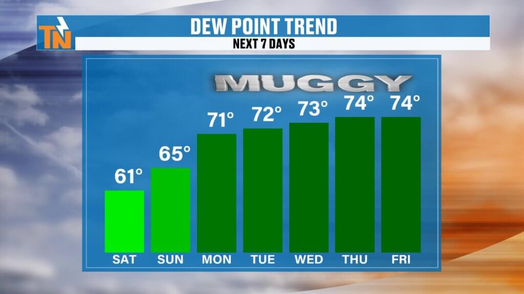
The gradual return of Gulf moisture is underway, and that trend will continue through the weekend and into next week.
While today remains mostly dry, the atmosphere is becoming increasingly moisture-rich. Meteorologists measure this using something called precipitable water, which represents the amount of moisture available in the atmosphere.
That moisture is steadily increasing.
As a result, any showers and thunderstorms that develop next week will be capable of producing very heavy rainfall in a short amount of time.
Saturday Forecast: Warm and Dry
High pressure remains anchored across the southeastern United States today, helping keep widespread rain at bay.
Expect:
- Partly to mostly sunny skies
- Increasing humidity
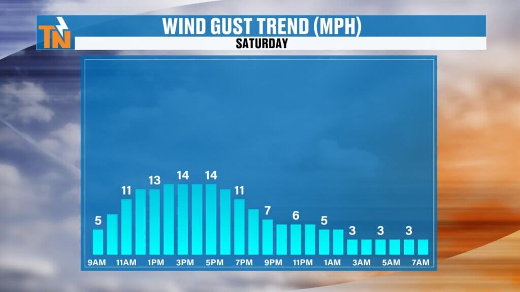
- Light to occasionally breezy winds
- Dry conditions for most locations
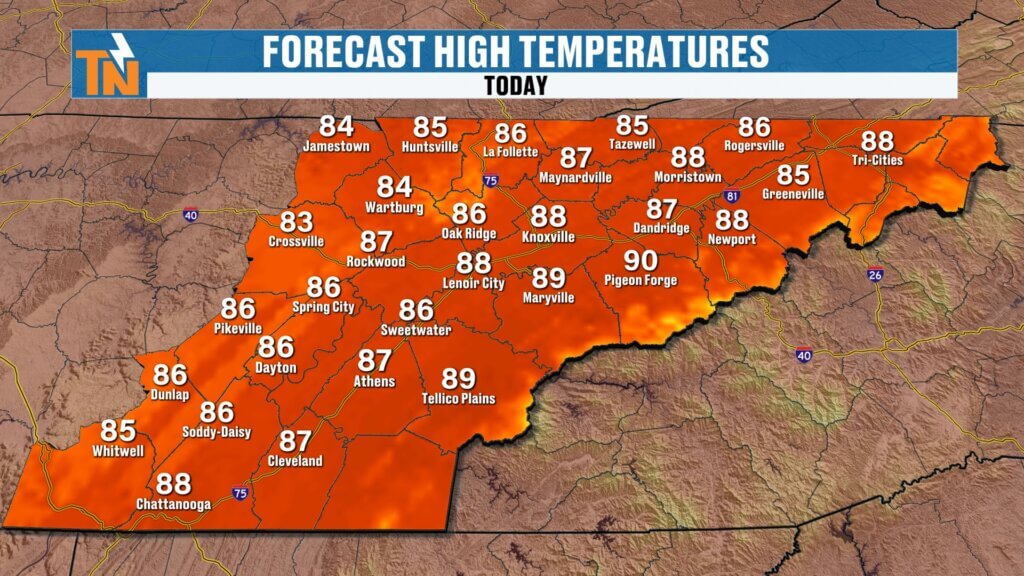
Afternoon temperatures will climb into the middle and upper 80s, placing us several degrees above average for this time of year.
Forecast highs include:
- Knoxville: Mid 80s
- Chattanooga: Upper 80s
- Tri-Cities: Mid 80s
- Crossville: Lower 80s
Average highs this time of year are generally in the lower 80s, so we’re running a few degrees warmer than normal.
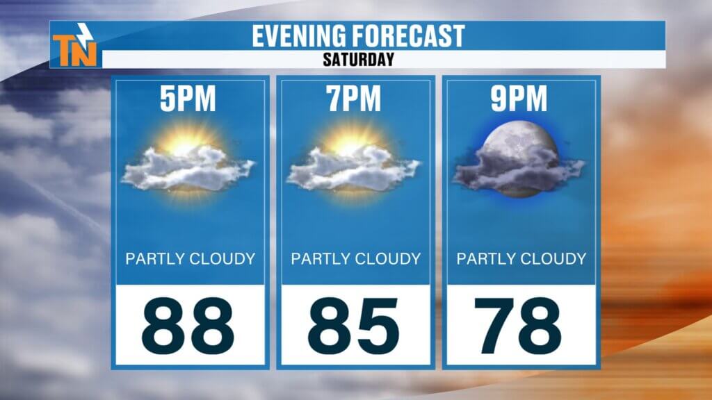
Evening temperatures remain warm as well, holding in the middle 80s through much of the early evening hours.
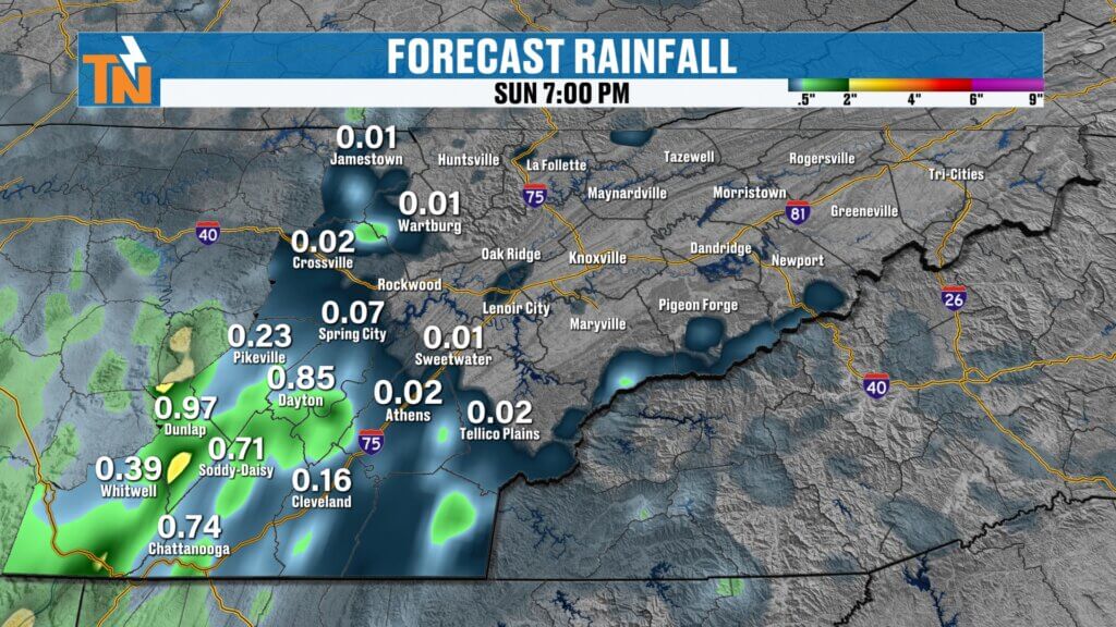
First Rain Chances Arrive Sunday
While today remains dry, the atmosphere begins changing on Sunday.
A disturbance approaching from the south and southwest will interact with increasing humidity levels, helping spark scattered showers and thunderstorms.
Rain coverage will not be widespread, but scattered storms will become more common during the afternoon and evening.
Current indications suggest:
- Sunday: Isolated to scattered storms
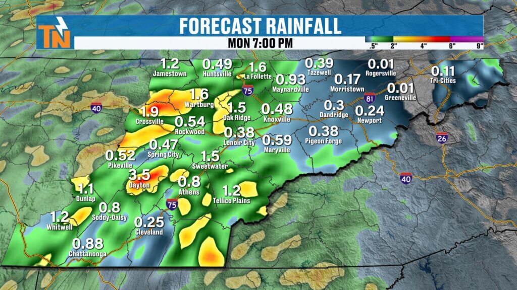
- Monday: Increasing storm coverage
- Tuesday: Numerous showers and thunderstorms
- Wednesday: Continued heavy rain potential
At this point, rain chances increase significantly beginning Sunday afternoon and continue through much of the middle of next week.
Tropical Moisture Fuels Heavy Rainfall Threat
The bigger story next week may not be severe weather.
Instead, it could be heavy rainfall.
A combination of deep tropical moisture, multiple disturbances, and slow-moving storm development may allow repeated rounds of rain to move over the same locations.
Forecast rainfall totals will vary significantly from one community to another, but some areas could receive several inches of rain over a relatively short period.
The setup resembles a classic summertime tropical moisture pattern where storms are capable of producing intense rainfall rates.
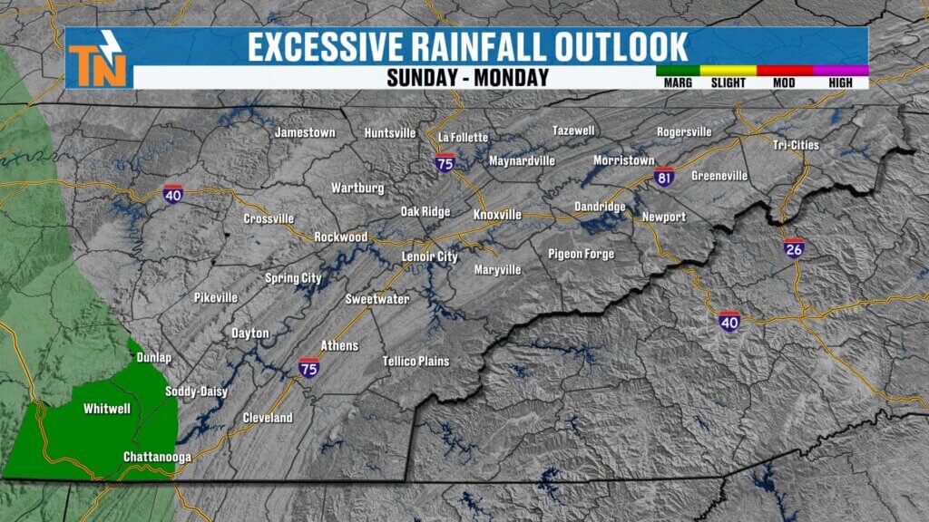
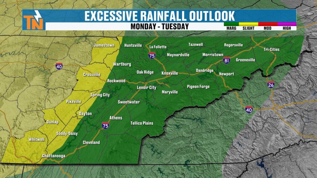
Flooding Concerns Increase Monday Through Wednesday
Because of the expected increase in moisture, excessive rainfall outlooks are already highlighting portions of the Tennessee Valley.
Current guidance indicates:
Monday into Tuesday:
- Level 1 and Level 2 flood risk
- Localized flooding possible
- Urban and poor drainage flooding concerns
Tuesday into Wednesday:
- Continued Level 1 flood risk
- Additional heavy rainfall possible
- Flash flooding concerns increase where rain repeatedly falls
While not everyone will experience flooding, the potential for localized issues certainly increases as multiple rounds of storms develop.
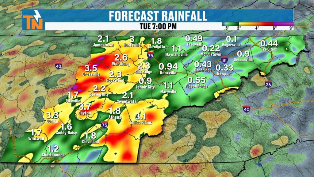
Who Has the Best Chance for Rain?
Current model guidance suggests the highest rainfall coverage may occur across:
- Cumberland Plateau
- Areas west of Interstate 75
- Central and Southern Tennessee Valley
Meanwhile, portions of Upper East Tennessee could see somewhat lower rainfall totals, although that could certainly change depending on storm development.
As always during summertime weather patterns, rainfall amounts can vary dramatically over short distances.
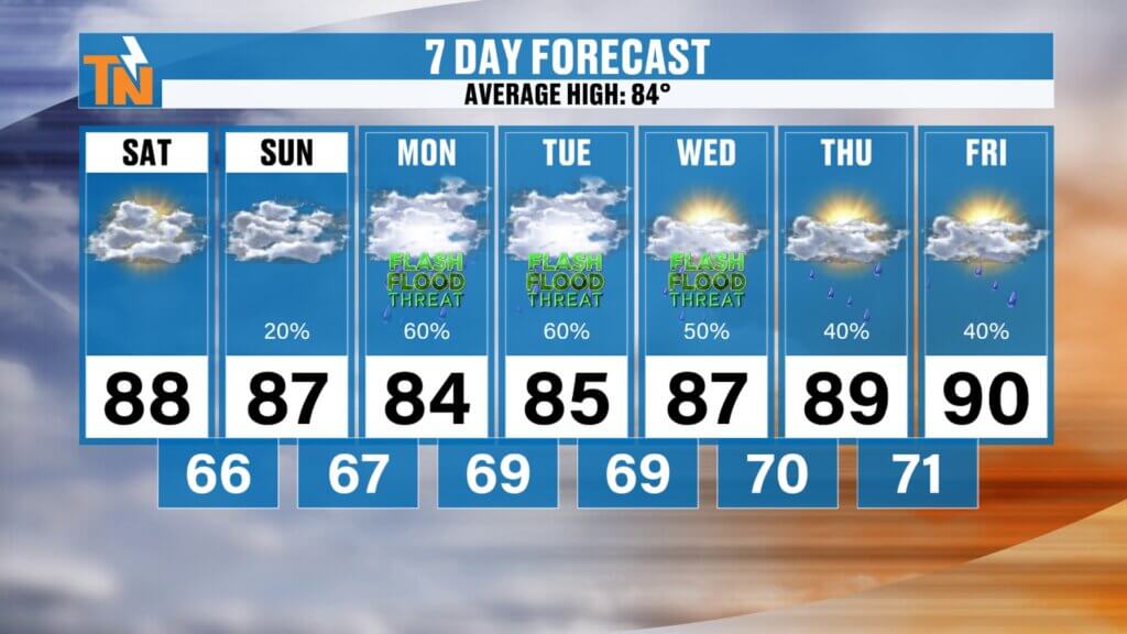
East Tennessee 7-Day Forecast
Saturday:
- Warm and dry
- High: Mid to upper 80s
Sunday:
- Increasing humidity
- Scattered afternoon storms
- High: Mid 80s
Monday:
- More widespread showers and storms
- Heavy rain possible
- High: Mid 80s
Tuesday:
- Tropical-like downpours possible
- Localized flooding concerns
- High: Mid 80s
Wednesday:
- Continued showers and thunderstorms
- Heavy rainfall possible
- High: Mid 80s
Thursday:
- Scattered storms remain possible
- Warm and humid
- High: Mid 80s
Friday:
- Typical summertime pattern
- Isolated to scattered storms
- High: Mid 80s
Bottom Line
Enjoy today because it will likely be the driest day in the forecast.
Humidity levels continue rising this weekend, and by early next week we’ll transition into a much more summer-like weather pattern. That means warmer nights, muggier afternoons, scattered thunderstorms, and the potential for periods of heavy rainfall.
Monday through Wednesday will be the timeframe to watch most closely, especially for localized flooding and tropical-style downpours.
As always, keep an eye on the radar and forecast updates throughout the weekend because rainfall amounts and storm coverage may continue to evolve.
Have a great Saturday, and enjoy the dry weather while it’s here!