
Good morning and happy Sunday, East Tennessee.
We’ve got an active weather day underway across the region as showers and thunderstorms continue to move through this morning, and flooding is becoming a growing concern.
If you’ve been with me the last several days, we’ve been talking about this setup.
High moisture.
Deep tropical air.
Training rounds of rain.
And now it’s happening.
Some areas have already picked up over 2 to 3 inches of rainfall, and with more rain on the way, flooding and flash flooding will continue to be the biggest weather story today.
Let’s break it all down.
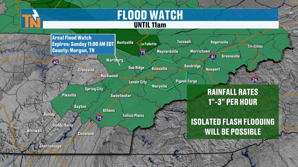
Flood Watch and Flash Flood Warnings Continue Across East Tennessee
A Flood Watch remains in effect through at least 11 AM this morning, and the National Weather Service may extend that depending on how today’s rain evolves.
We’re also tracking multiple Flash Flood Warnings this morning.
That means flooding is either already happening or expected to happen soon.
This is not a “watch and wait” setup in some spots.
It’s already happening.
Especially in flood-prone areas, creeks, streams, and low-lying roads.
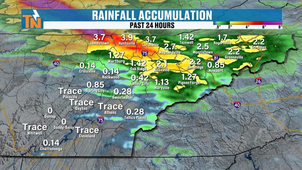
East Tennessee Rainfall Totals Already Climbing
The rainfall over the last 24 hours has been significant.
Some of the highest totals so far:
- Fentress County: 2 to nearly 3 inches
- Scott County: 2+ inches
- Campbell County: 2+ inches
- Knoxville / McGhee Tyson Airport: nearly 2 inches
And we’re not done.
Additional rainfall rates today could still hit:
1 to 3 inches per hour
That kind of rainfall can overwhelm drainage systems fast.
Why the Flood Risk Remains High Today
We still have deep moisture streaming in from northwest to southeast.
That means:
- Saturated ground
- Creeks already running high
- Heavy rain still moving through
- Additional rounds possible into the afternoon
This setup can quickly worsen flooding.
The biggest concern today is where rain continues to train over the same areas.
That’s especially true across:
- Interstate 40 corridor
- Interstate 81 corridor
- Upper East Tennessee
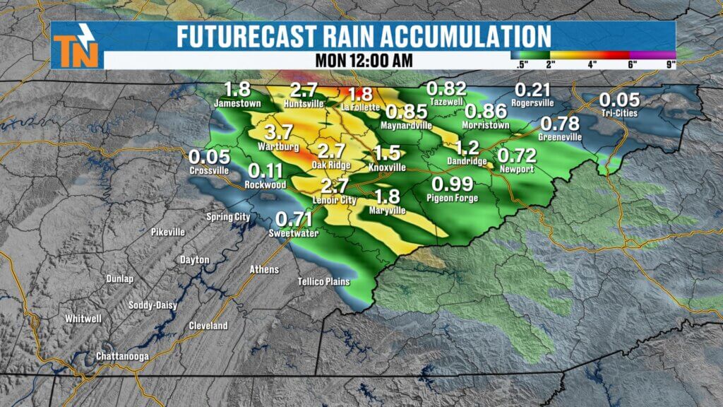
Futurecast: When Does the Rain End?
Through Lunchtime
Rain remains widespread.
The heaviest bands will focus:
- Along I-40
- Through Knoxville
- North toward Morristown
- Northeast along I-81
This will be the highest flood concern period.
This Afternoon
The bulk of the organized rain starts pulling away.
However:
- Spotty showers remain
- A few thunderstorms linger
- Localized downpours still possible
Flooding doesn’t stop immediately just because the rain weakens.
Runoff will continue.
This Evening
Rain coverage drops significantly after sunset.
Conditions begin improving.
Any Severe Weather Today?
The severe weather risk is lower today.
Most of the organized severe threat shifts east into North Carolina.
However:
A few storms could still produce:
- Wind gusts 40 to 45 mph
- Frequent lightning
- Heavy rain
So while widespread severe weather isn’t expected, stronger storms remain possible.
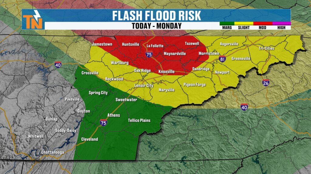
Flood Risk Highest in Upper East Tennessee
The Weather Prediction Center has highlighted Upper East Tennessee under a Level 2 flood risk.
That includes:
- Johnson City
- Kingsport
- Greeneville
- Along the I-81 corridor
South of I-40:
Less rain is expected.
That also means:
Higher temperatures.
Higher heat index values.
Sunday Forecast: Rain North, Heat South
This morning:
Upper 60s to 70s.
Still muggy.
Still stormy.
This afternoon:
- Upper East Tennessee stays cooler due to clouds and rain
- Southern Valley heats into upper 80s to low 90s
That includes:
- Chattanooga
- Cleveland
- Athens
Less rain = more heat.
More rain = cooler temperatures.
Simple as that.
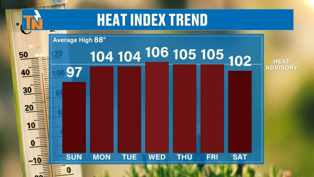
Next Week: The Hottest Weather of the Season Arrives
Once this storm system exits, the weather flips.
A strong ridge of high pressure builds in.
And this is a classic summer heat setup.
We’re talking:
- Minimal rain
- Strong sunshine
- Very high humidity
- Dangerous heat
Forecast highs:
Monday: 91°
Tuesday: 93°
Wednesday: 94°
Thursday: 95°
Friday: 95°
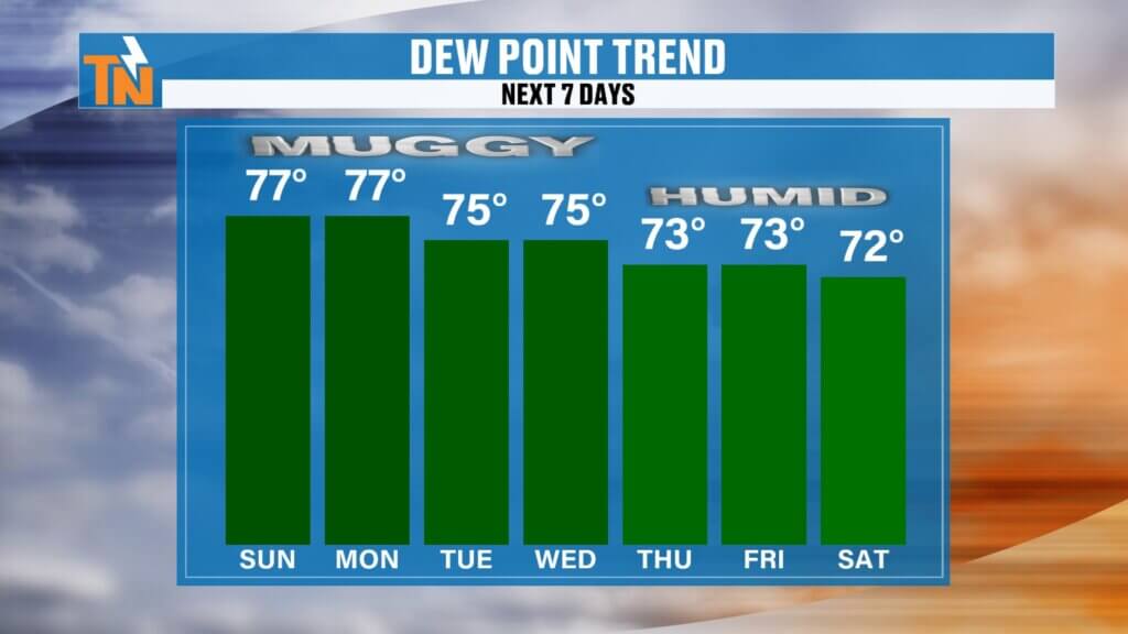
And with dew points staying in the mid to upper 70s…
Heat index values could reach:
100° to 105°
That’s approaching Heat Advisory criteria.
This will likely be the hottest stretch of the year so far.
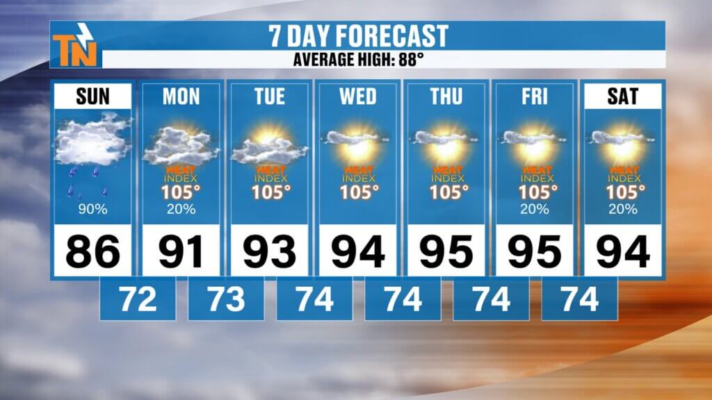
East Tennessee 7-Day Forecast
Sunday
Heavy rain early, improving later
High: 86°
Monday
Mostly sunny and hotter
High: 91°
Tuesday
Hot and humid
High: 93°
Wednesday
Dangerous heat builds
High: 94°
Thursday
Heat index near 105°
High: 95°
Friday
Hot and muggy
High: 95°
Saturday
Mostly sunny, isolated storm
High: 94°
Bottom Line
Today is about flooding.
Heavy rain this morning.
Localized flash flooding.
More warnings possible.
The highest concern remains across Upper East Tennessee and the I-81 corridor.
Conditions improve later today.
And then the weather flips hard.
Next week will bring:
The hottest weather of the season.
Stay weather aware this morning.
Never drive through flooded roads.
Turn around, don’t drown.
And make sure you have the East Tennessee Weather downloaded to track rain and alerts in real-time.
Have a great Sunday, and Happy Father’s Day.