
Good morning and happy Monday, East Tennessee.
I sure hope you had a great weekend.
It was a stormy one for many of us, with some locations picking up significant rainfall. Officially at McGhee Tyson Airport, nearly 2 inches of rain fell yesterday alone.
But now…
The weather pattern is changing.
And it’s changing fast.
The heavy rain is moving out.
The heat is moving in.
And what we’re stepping into this week is the first true heat wave of summer across East Tennessee.
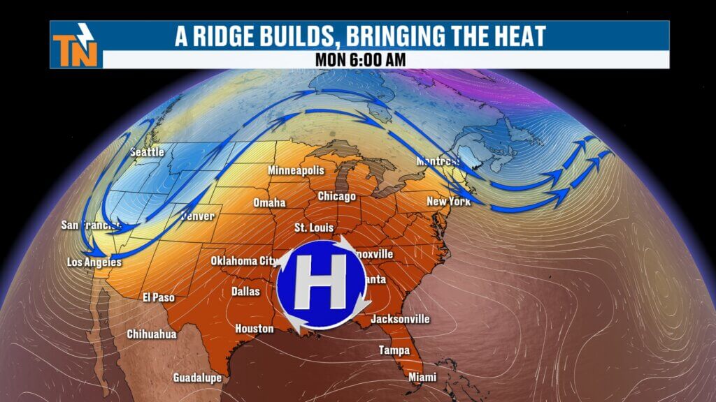
East Tennessee Weather Pattern Shifts: Ridge of High Pressure Builds In
The big weather story this week is a strong ridge of high pressure building across the southeastern United States.
That ridge will dominate the weather pattern for the next 7 to 10 days.
What does that mean?
It means:
- Hotter temperatures
- Higher humidity
- Lower rain chances
- Dangerous heat index values
We’ve been talking about this transition for several days now.
And now it’s here.
The ridge itself acts like a heat dome, trapping warm air and allowing temperatures to soar.
Around the edges of that ridge, little disturbances can “ride the rim” and occasionally trigger isolated pop-up showers and storms.
That’s exactly what we’ll be watching today.
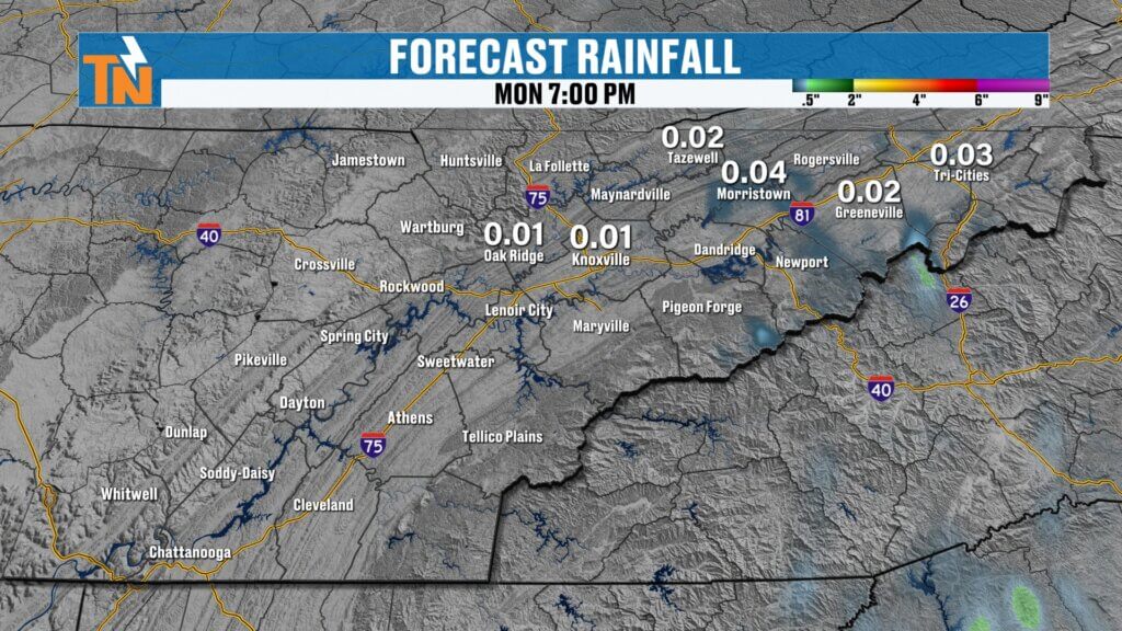
Isolated Showers Possible Today, Mainly Upper East Tennessee
Not everybody sees rain today.
In fact, most of East Tennessee stays dry.
But there is a small disturbance diving south along the eastern edge of this ridge.
That means a few isolated showers or storms may develop, especially across:
- Johnson City
- Kingsport
- Greeneville
- Mountain communities
- Higher terrain along the Smokies
Futurecast suggests very limited activity.
Most models keep things fairly quiet.
But the National Blend of Models shows slightly better chances in Upper East Tennessee.
Rain chances today:
20%
Mainly afternoon.
Dense Fog This Morning Across East Tennessee
A lot of areas woke up with dense fog.
That’s no surprise after heavy rainfall and tropical humidity over the weekend.
Watch for reduced visibility this morning, especially near:
- Rivers
- Lakes
- Valleys
- Low-lying areas
Use caution on the morning drive.
Fog will burn off after sunrise.
Monday Forecast: Steam Bath Conditions Return
This morning is already rough.
Temperatures started in the low to mid 70s.
Dew points are also in the 70s.
That means the air is absolutely loaded with moisture.
When you step outside…
It’s going to hit you right in the face.
That “steam bath” feel is back.
And it’s not going anywhere this week.
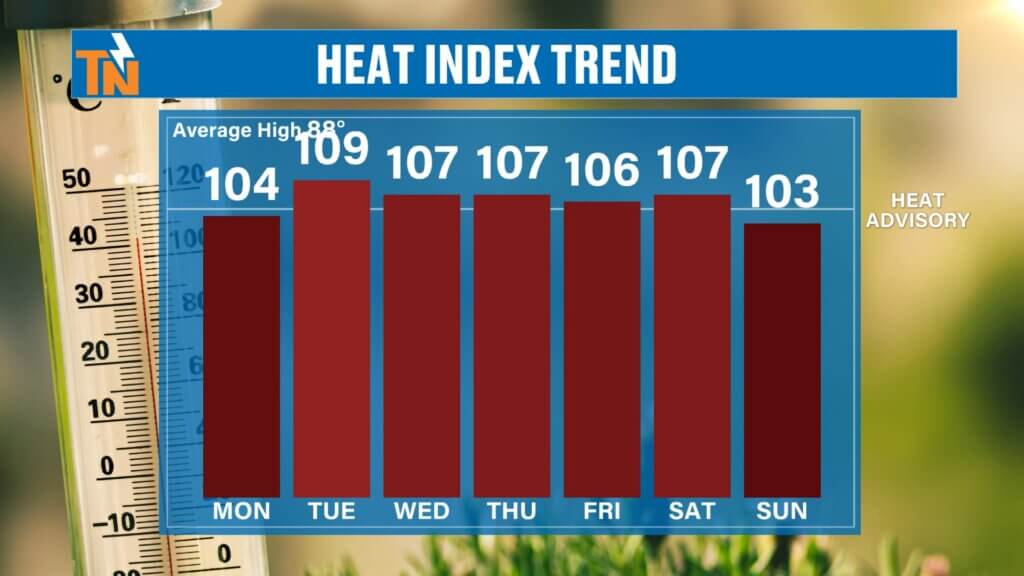
Dangerous Heat Builds Across East Tennessee This Week
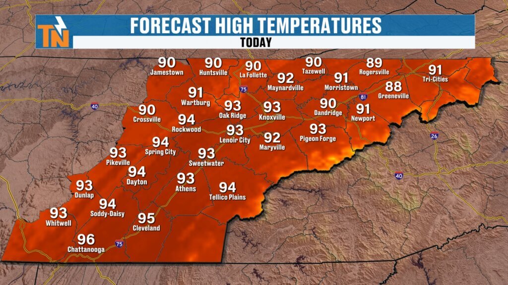
Today’s high temperatures:
Low to mid 90s
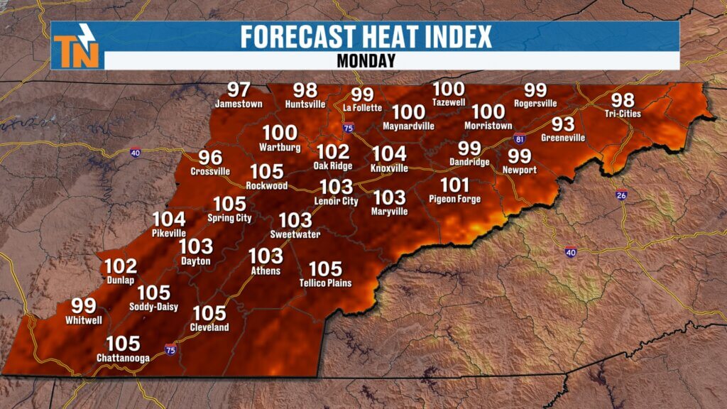
But the actual air temperature only tells part of the story.
Because when you combine temperatures in the 90s with dew points in the 70s…
The heat index jumps dramatically.
Expected heat index values:
100° to 105°
Some spots could go higher.
That’s near Heat Advisory criteria.
And this won’t just be a one-day thing.
This will be a prolonged stretch.
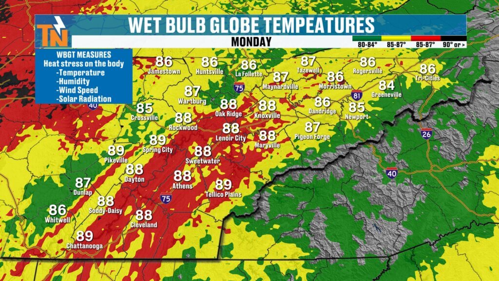
Why This Heat Matters: Wet Bulb Globe Temperature Explained
As we get deeper into summer sports and outdoor practices, this becomes more important.
The Tennessee Secondary School Athletic Association uses Wet Bulb Globe Temperature (WBGT) for outdoor sports.
WBGT measures:
- Air temperature
- Humidity
- Wind speed
- Solar radiation
- Heat stress on the body
This matters because your body cools less efficiently in high humidity.
And with this kind of heat coming…
Athletes, coaches, and parents need to pay attention.
Especially later this week.
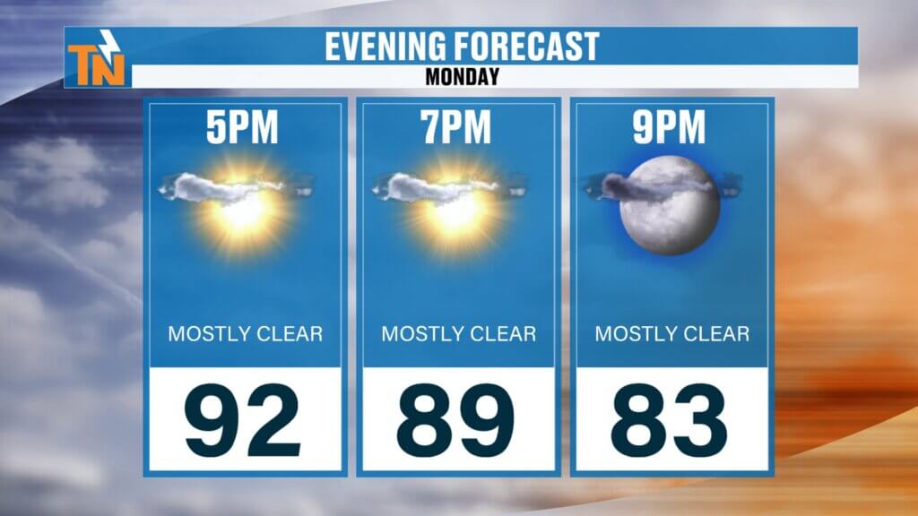
Evening Forecast: Very Little Relief
Even by 7 PM tonight:
Temperatures will still be in the upper 80s.
That’s hot.
And still humid.
Not much relief after sunset.
Overnight lows stay in the 70s all week.
That means poor overnight cooling.
That increases heat stress.
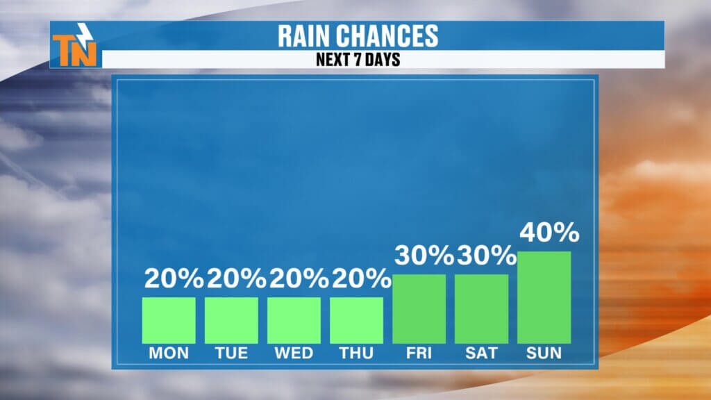
Minimal Rain Through the Week
Rain chances stay low.
Could we see a few isolated pop-ups?
Sure.
Especially:
- Cumberland Plateau
- Great Smoky Mountains
But widespread rain?
Not likely.
This week is mainly about heat.
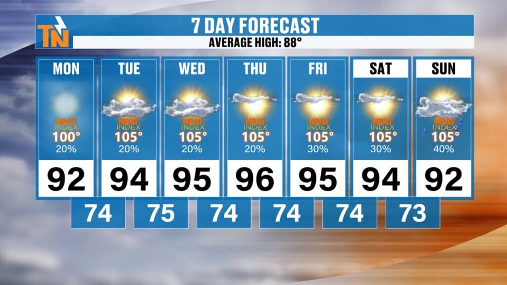
East Tennessee 7-Day Forecast
Monday
Hot and humid
Isolated shower possible
High: 93°
Tuesday
Sunny and hotter
High: 94°
Wednesday
Dangerous heat
High: 95°
Thursday
Heat index near 105°
High: 95°
Friday
Very hot and muggy
High: 94°
Saturday
Hot with isolated pop-up storm
High: 94°
Sunday
Continued heat
High: 93°
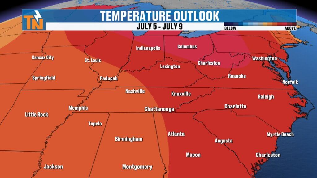
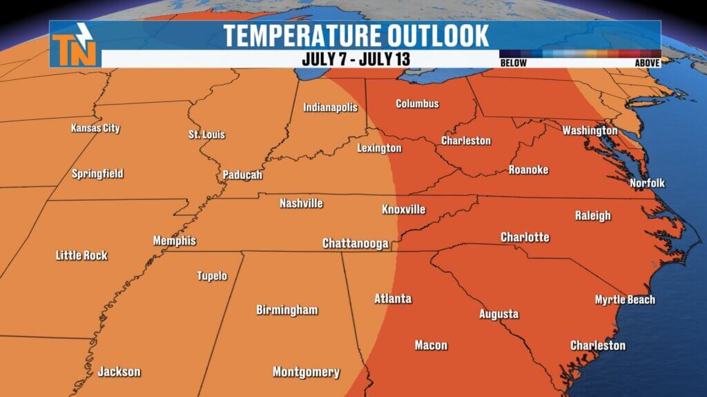
Long Range Outlook: Heat Lasting Into July
The Climate Prediction Center continues to show above-average temperature probabilities extending into the second week of July.
That means:
This isn’t a quick heat burst.
This could be the beginning of a long stretch of summer heat.
Heat Safety Tips This Week
If you work outside:
- Take extra breaks
- Drink plenty of water
- Wear loose, light-colored clothing
- Limit direct sun exposure
If you’re heading to:
- The lake
- The pool
- Outdoor camps
- Summer sports
Remember:
UV index values will be very high.
Sunburn happens fast.
Use sunscreen.
Stay hydrated.
Watch for heat exhaustion.
Bottom Line
The stormy weekend is over.
The heat wave begins.
Today starts the transition into the hottest weather of the year so far.
Low to mid 90s all week.
Heat index values near 105°.
Very little rain.
Very little relief.
This is our first major summer heat wave.
Take it seriously.
And make sure you have the East Tennessee Weather downloaded to track any pop-up storms and get heat alerts this week.
Have a great Monday and stay cool.