
Good morning and happy Thursday, East Tennessee.
The heat continues to build.
And today and tomorrow will likely be the hottest stretch of this current heat wave before we begin a gradual cooling trend heading into next week.
Now, I say “cooling trend” loosely.
We’re not talking cool.
We’re just talking slightly less hot.
Yesterday we topped out at 95 degrees in Knoxville, and today we’re expected to climb even hotter.
That puts us just 10 degrees shy of the all-time record high of 105 degrees, set back in 2012.
And with humidity staying high, it’s not just the air temperature that matters.
It’s how it feels.
And today?
It’s going to feel brutal.
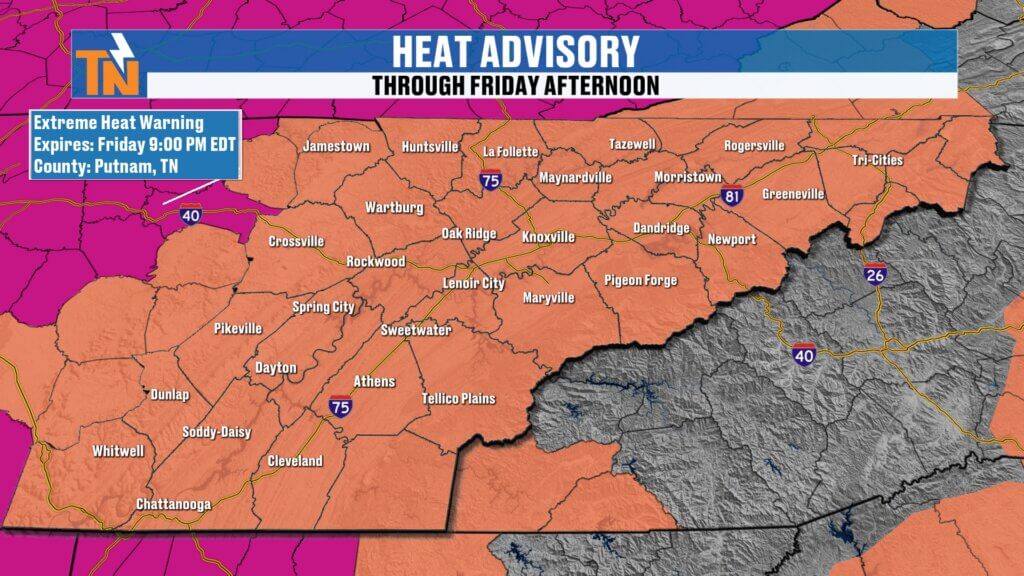
Heat Advisory Continues Across East Tennessee
The National Weather Service continues the Heat Advisory through Friday for much of East Tennessee.
Meanwhile, extreme heat warnings remain in effect just to our west and north.
That gives you an idea of just how dangerous this heat really is.
This morning:
- Temperatures are already in the low to upper 70s
- Dew points are holding in the 70s
- It’s warm, sticky, and uncomfortable before sunrise
That’s never a good sign.
When mornings start this warm, afternoons get dangerous fast.
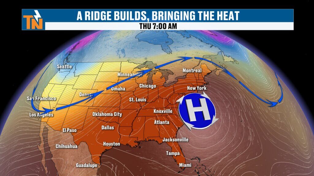
Why It’s So Hot: Ridge of High Pressure Still in Control
That ridge of high pressure we’ve been talking about all week?
Still in charge.
But it is shifting east and southeast.
That puts East Tennessee on the western side of the ridge.
And that matters.
Why?
Because it opens the door for:
- More moisture
- More instability
- More energy in the atmosphere
And that’s why we’re talking about isolated storms.
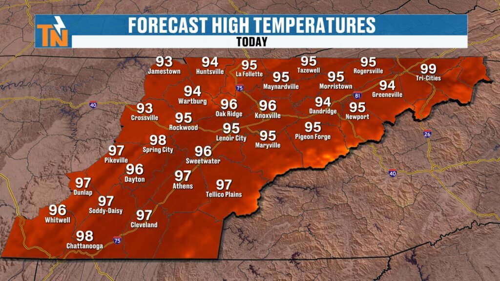
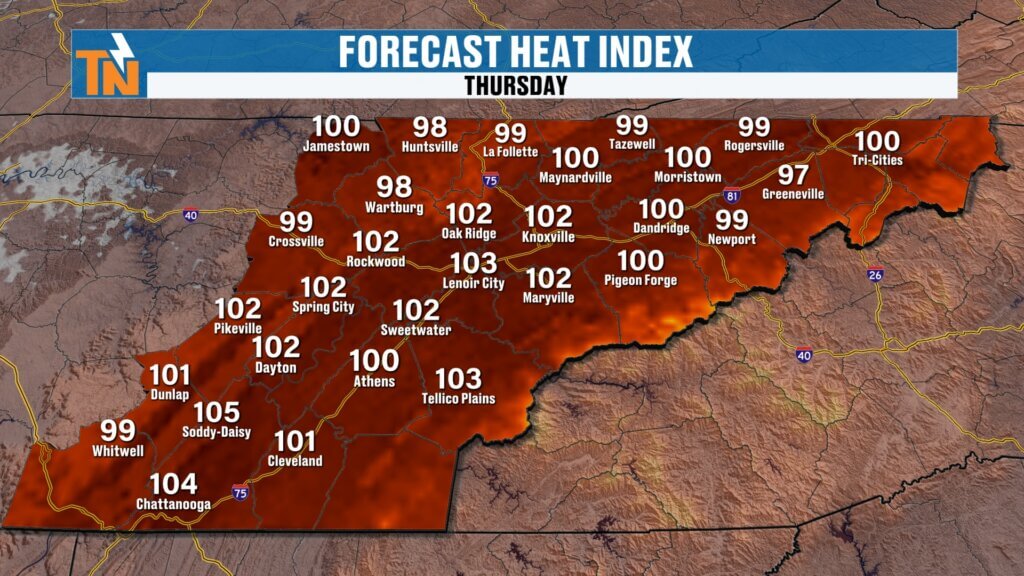
Forecast for Today: Mid 90s with Heat Index Near 106°
Today’s forecast:
Knoxville: 96°
Heat index:
100° to 106°
Some spots could briefly hit heat advisory criteria.
Yesterday, McGhee Tyson Airport came close.
Today may get there.
Winds will be light to occasionally breezy.
And honestly…
That breeze will feel nice.
But it won’t do much to cool you down.
Even by 7 PM tonight:
Still around 92°
That tells you everything.
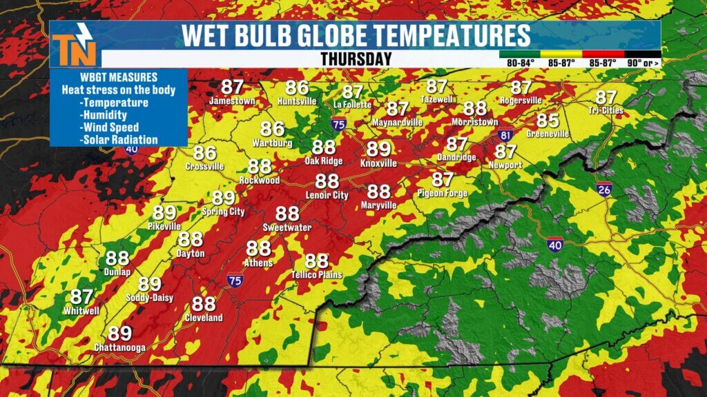
Wet Bulb Globe Temperature: Why This Heat Is Dangerous
This is important.
Especially if you:
- Work outside
- Coach sports
- Have kids practicing
- Exercise outdoors
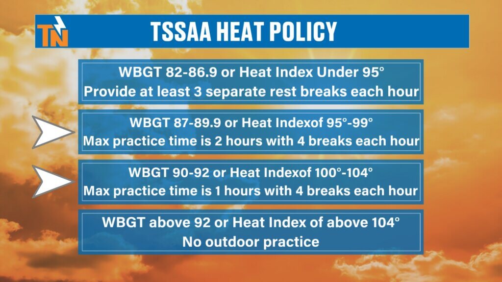
The Tennessee Secondary School Athletic Association uses Wet Bulb Globe Temperature (WBGT).
It factors in:
- Air temperature
- Humidity
- Wind speed
- Solar radiation
Today:
WBGT values will run upper 80s to low 90s
That’s dangerous.
Recommended:
- Four breaks every hour
- 4–5 minutes each
- Get into shade or AC when possible
This doesn’t just apply to athletes.
It applies to:
Roofers.
Construction crews.
Landscapers.
Delivery drivers.
Parents outside with kids.
Heat exhaustion can happen fast.
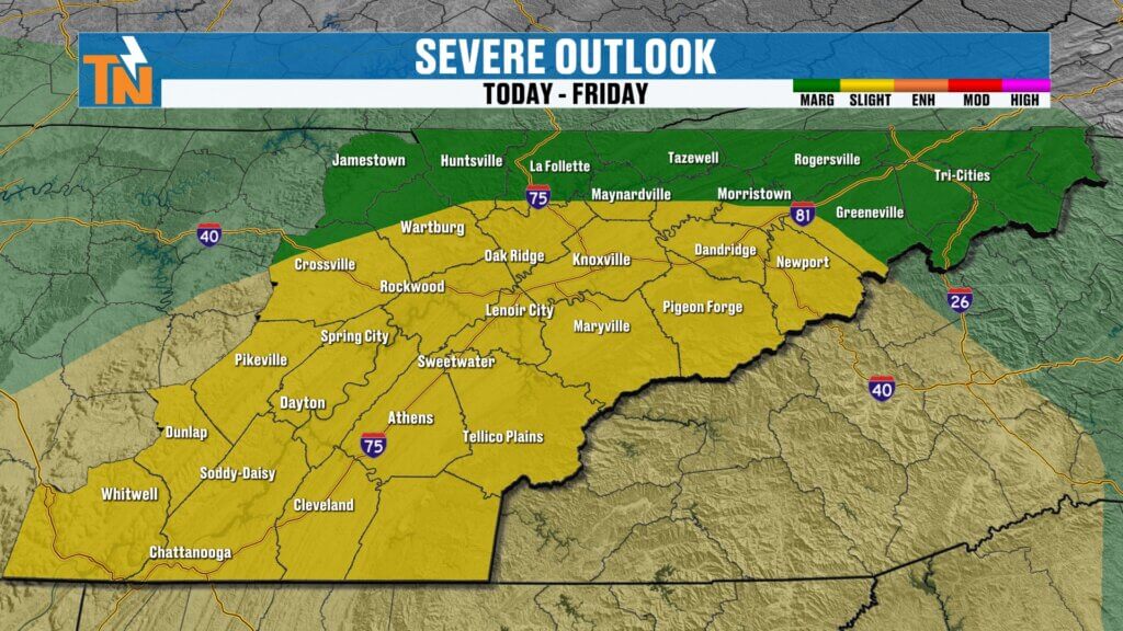
Storm Chances Today: Spotty but Could Be Strong
The heat is the bigger story.
But storms are still on the table.
And because the atmosphere is loaded with instability…
Any storm that forms could quickly become strong.
The best setup today:
- Cumberland Plateau
- Southern Valley
- Southern Smokies
Think areas like:
- Chattanooga
- Cleveland
- Athens
- Sevierville
Timing:
After 2 PM through sunset
Storm threats:
- Strong wind gusts
- Frequent lightning
- Heavy rainfall
- Small hail
Not everyone sees rain.
But if you do?
It could be intense.
Unusual Storm Motion: Southeast to Northwest
This is unusual.
Most East Tennessee storms move west to east.
Not this time.
Because of the ridge placement, storms today will move:
Southeast → Northwest
That’s a different setup.
And it’s one reason forecasting exact storm placement gets tricky.
Fourth of July Forecast: Storm Chances Still Around
Saturday (July 4th):
Still hot.
Still humid.
Still watching for isolated storms.
Especially off the mountains into the valley.
Storms may develop and drift west-northwest again.
Not a washout.
But you’ll want to watch radar before fireworks.
Sunday:
A few more pop-up storms.
Storm motion becomes more typical again.
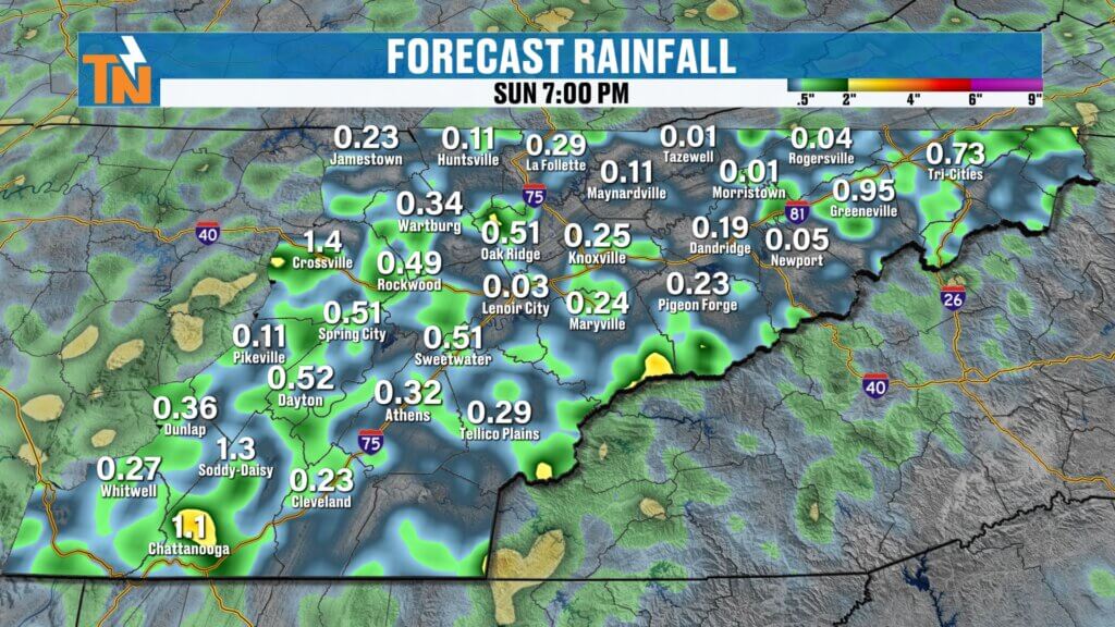
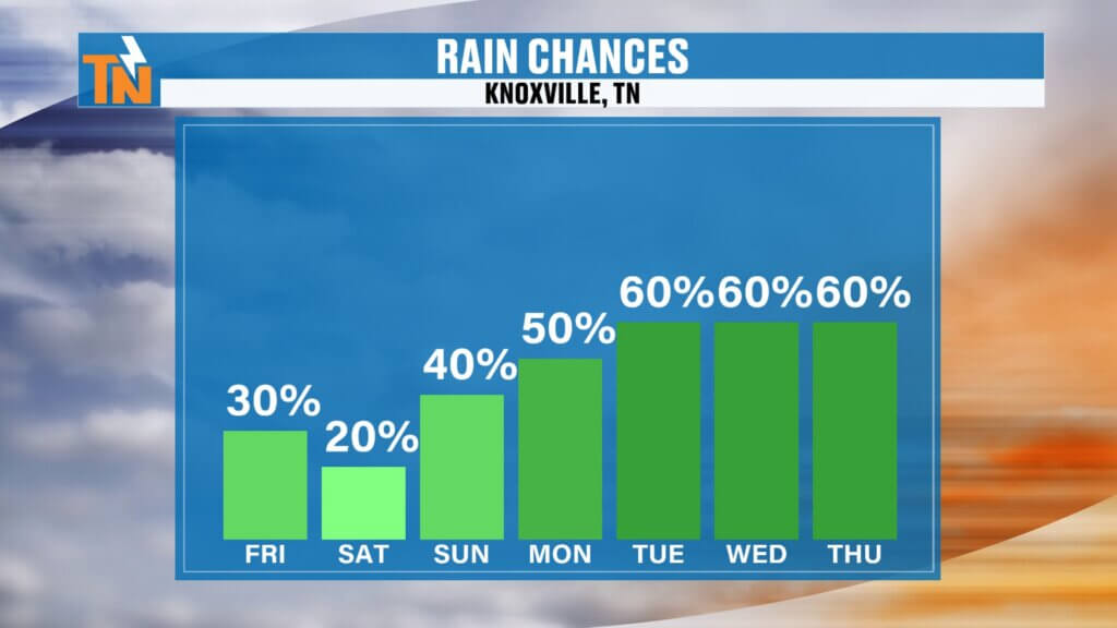
Rainfall Outlook
Rainfall remains very spotty.
Not everyone gets it.
But if you do:
Heavy tropical-like downpours remain possible.
That’s because:
- High moisture content
- High instability
- Slow-moving storms
Localized flooding isn’t impossible.
Just not widespread.
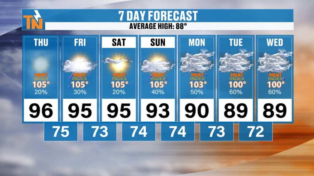
East Tennessee 7-Day Forecast
Thursday
Hot and dangerous
Spotty storms
High: 96°
Friday
Still hot
Isolated storms
High: 95°
Saturday (July 4th)
Hot and humid
Spotty storms possible
High: 94°
Sunday
Scattered afternoon storms
High: 92°
Monday
Slightly cooler
Better rain chances
High: 89°
Tuesday
More storms
Less heat
High: 88°
Wednesday
Seasonably warm
High: 88°
Bottom Line
Today and tomorrow remain dangerous heat days.
Heat Advisory continues.
Heat index near 105° to 106°.
Spotty storms this afternoon, mainly south and west.
Fourth of July still looks hot with isolated pop-ups.
Cooling trend begins next week.
And remember:
Drink plenty of water.
Take extra breaks.
Limit strenuous activity during peak heating.
And if you work outside…
Follow the example of the roofers.
Work smart.
Work safe.
Have a great Thursday, East Tennessee.