
Good Morning, East Tennessee
Happy Monday, everybody! Hope you had a fantastic Mother’s Day weekend.
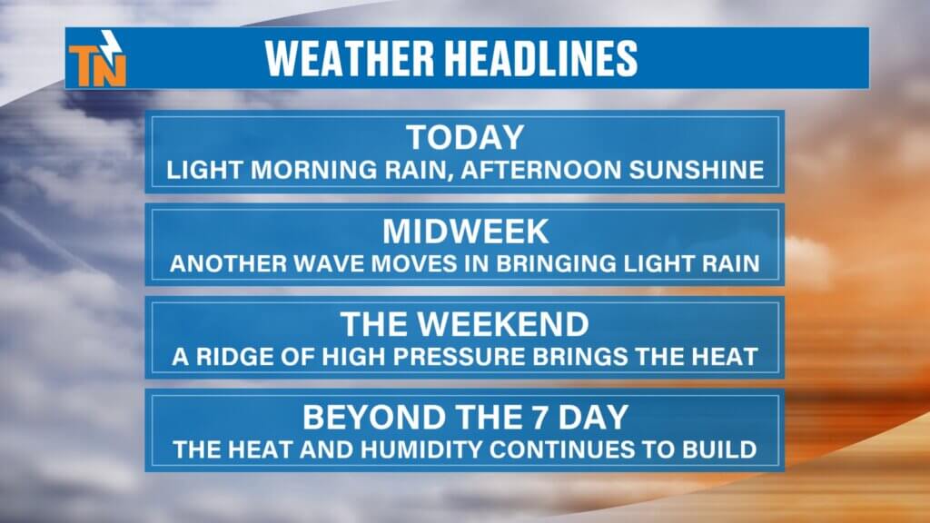
After a warm and summerlike Sunday with highs climbing into the low to mid-80s across much of East Tennessee, we’re starting the new week on a slightly cooler note. A weak disturbance is moving through this morning, bringing some light rain showers, but don’t worry — sunshine makes a comeback later today.

Weekend Heat Gives Way to a Cooler Start
Yesterday definitely felt more like summer.
Sunday highs included:
- 85° in Chattanooga
- 82° in Knoxville
- Upper 70s to middle 80s across much of East Tennessee
A little humidity was in the air, but nothing too uncomfortable — at least not yet. That’s going to change as we head deeper into May.
Light Rain This Morning, Sunshine Later
A weak disturbance is sliding through East Tennessee this morning, bringing scattered light rain showers, mainly along and north of Interstate 40.
What to expect today:
- Light rain early this morning
- Most rain focused north of I-40
- Clouds gradually clearing this afternoon
- Sunshine returns after 3 PM
Rainfall totals will stay pretty limited:
- Up to around 0.25″ in isolated spots north of I-40
- Less rainfall south of Interstate 40
This won’t be a major rain event by any stretch. Just enough to dampen the morning commute for some areas.
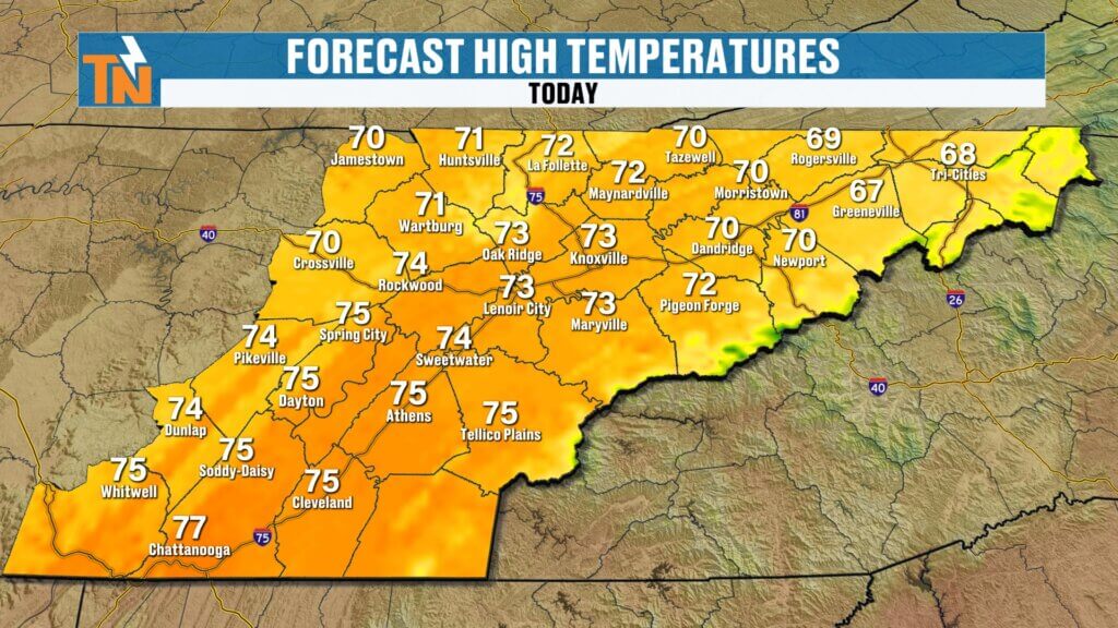
Cooler Temperatures Settle In
Thanks to cloud cover and cooler air filtering in, temperatures today will run about 10 degrees cooler than Sunday.
Forecast highs:
- Knoxville: Around 73°
- Chattanooga: Near 77°
- Tri-Cities: Around 68°
- Rogersville: Upper 60s
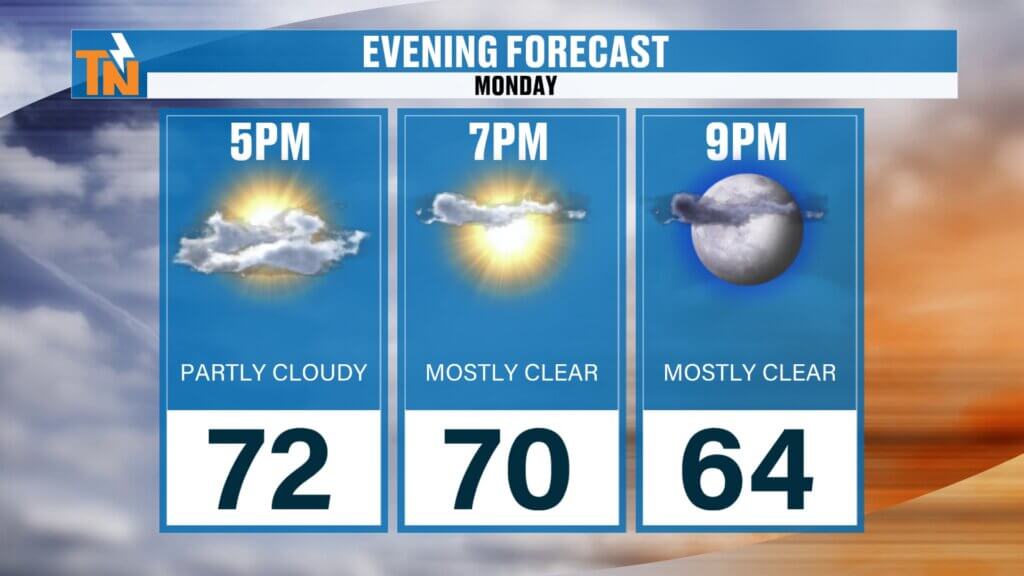
A breezy north wind will stick around at times, but nothing too strong. By this evening, conditions turn pleasant for a walk, dinner outside, or maybe even a little fishing. Temperatures this morning are generally in the 40s and 50s before warming quickly this afternoon.
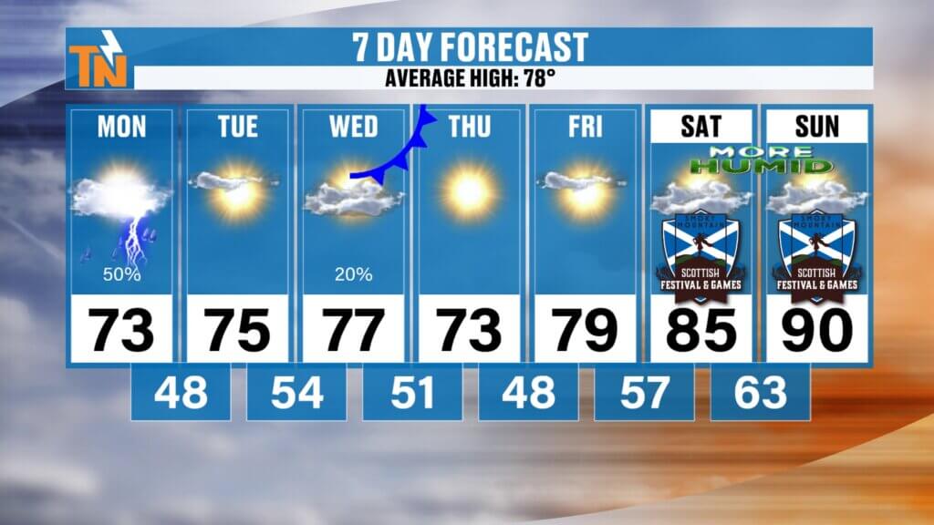
Another Weak System Arrives Midweek
We’re also tracking another weak disturbance for Wednesday into Thursday.
The good news:
- Severe weather chances remain low
- Ingredients for stronger storms won’t fully come together
- Rainfall totals stay light once again
A few showers may develop Wednesday, but widespread heavy rain is not expected.
Summerlike Heat Builds This Weekend
After a brief cool-down, the weather pattern flips again.
A ridge of high pressure builds back into the Southeast, bringing:
- Warmer temperatures
- More sunshine
- Rising humidity levels
Unlike recent warm spells, humidity will start becoming noticeable as dew points climb into the 60s. That means it’s finally going to feel muggy around East Tennessee.
Weekend outlook:
- Friday: Upper 70s
- Saturday: Low to mid-80s
- Sunday: Near 90° possible in some spots
Yes… summerlike heat is knocking on the door.
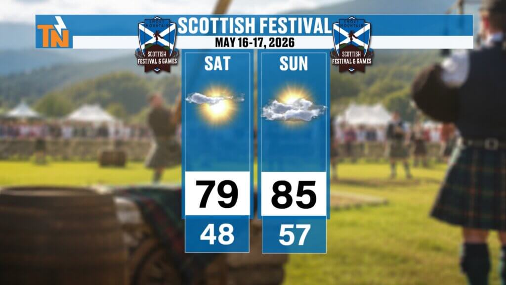
Scottish Festival Forecast Looking Hot and Dry
If you’re headed to the Scottish Festival in Townsend this weekend (May 16–17), the forecast is shaping up nicely.
Expected conditions:
- Dry weather
- Plenty of sunshine
- Highs in the low to mid-80s
- Slightly cooler in Townsend than Knoxville
Definitely warm, but overall fantastic festival weather.
Looking Ahead
The pattern this week stays fairly quiet with only a couple weak disturbances bringing light rain. Then, as we head into the weekend, heat and humidity start building back in across East Tennessee.
If you’ve been waiting for summer weather… it’s on the way.