
Tuesday Overview
Happy Tuesday! Thanks for checking in.
We started the day with some impactful overnight weather—heavy rain, a few power outages, and plenty of beneficial moisture. While severe weather was limited early, we’re not done yet.
Another round of storms is on the way tonight, followed by additional storm chances into Wednesday, including the potential for a few strong to severe thunderstorms.

What Happened Overnight
- Steady, heavy rainfall moved through East Tennessee
- Localized power outages reported
- No widespread severe weather, but impactful rain
This was the kind of soaking rain we’ve been needing.
Tuesday Forecast: Morning Rain, Break, Then Storms Return
Here’s how today plays out:
- Morning: Rain tapers off with gradual clearing
- Afternoon: Mostly cloudy with some breaks of sun
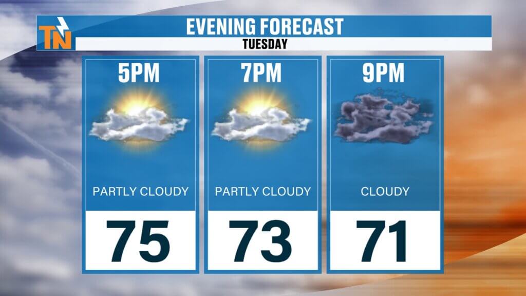
- Evening: Dry through sunset
- Tonight: Storms redevelop and move in
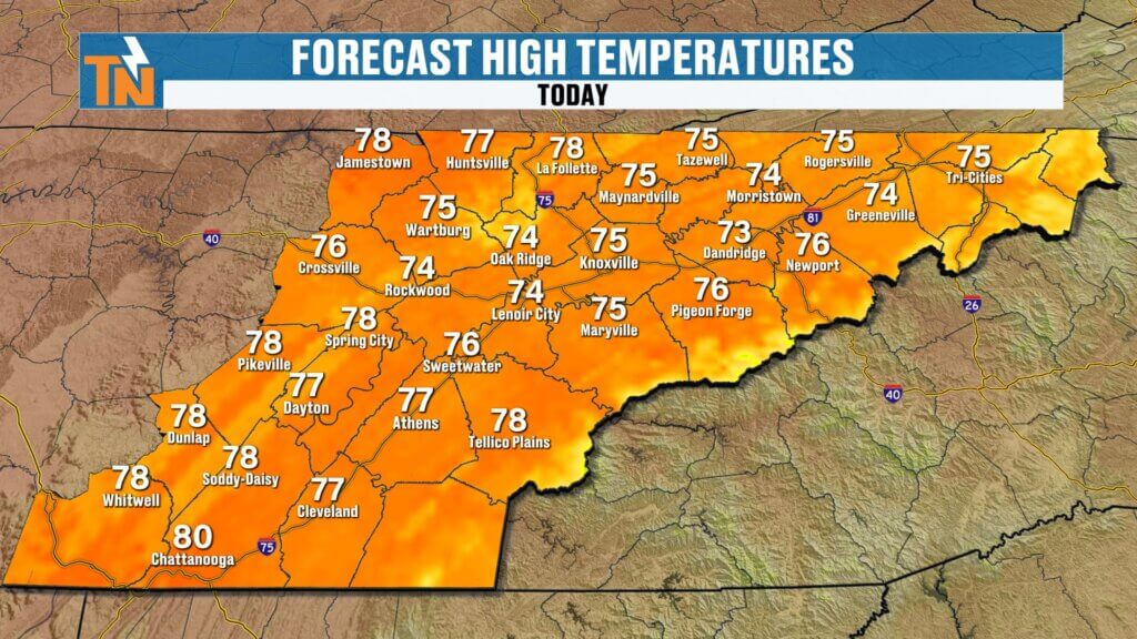
Temperatures:
- Morning lows: 50s and 60s
- Afternoon highs: Mid 70s (more seasonal)
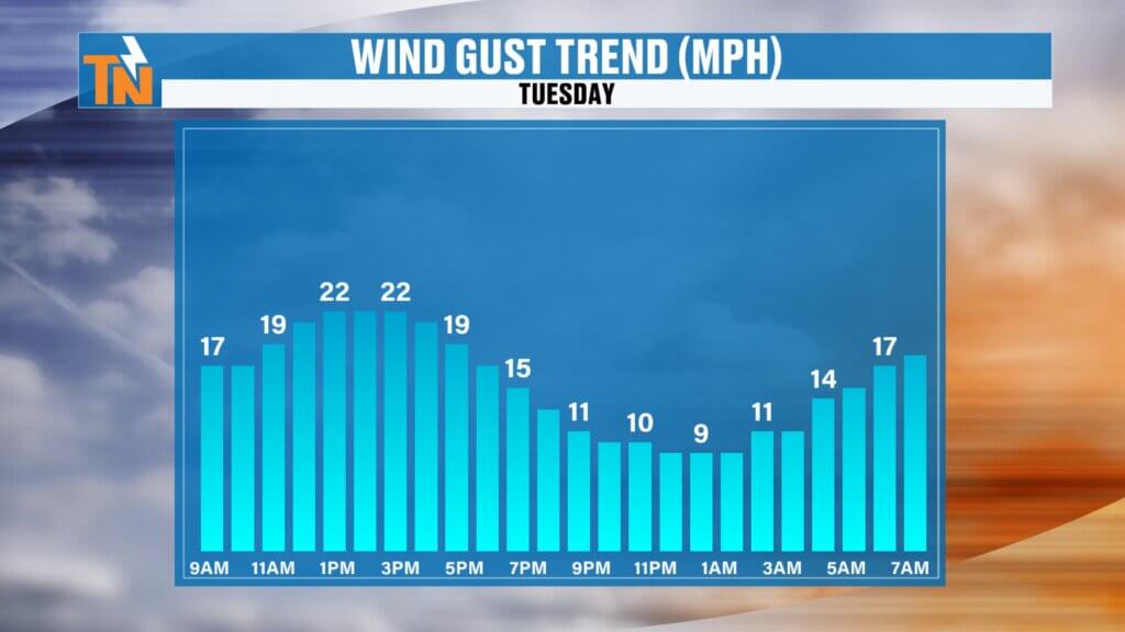
Winds:
Breezy to gusty at times
Increasing through the day
Tonight’s Storm Threat
Storms return after sunset:
- Plateau: As early as 7–8 PM
- Valley: Midnight to 2 AM
- Overnight: Storms move through quickly
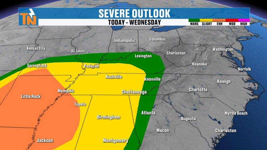
The Storm Prediction Center has placed East Tennessee under a Level 1 to Level 2 risk.
Main threats:
- Damaging wind gusts
- Heavy rain
- Frequent lightning
Make sure to stay weather-aware before heading to bed.
Wednesday: Another Active Day
The unsettled pattern continues:
- Morning: Lingering rain and storms
- Afternoon: Cold front moves through
- Additional showers and storms may redevelop
There is still a chance for a few strong storms during the afternoon as the front pushes through.
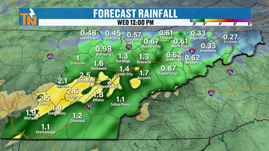
Rainfall Totals: Big Help for the Drought
Between now and Wednesday evening:
- Additional rainfall: 0.50″ to 1″+
- Combined with earlier rain, this is significant
This is very beneficial for drought conditions across East Tennessee.This is especially important as those areas are still dealing with ongoing drought conditions.
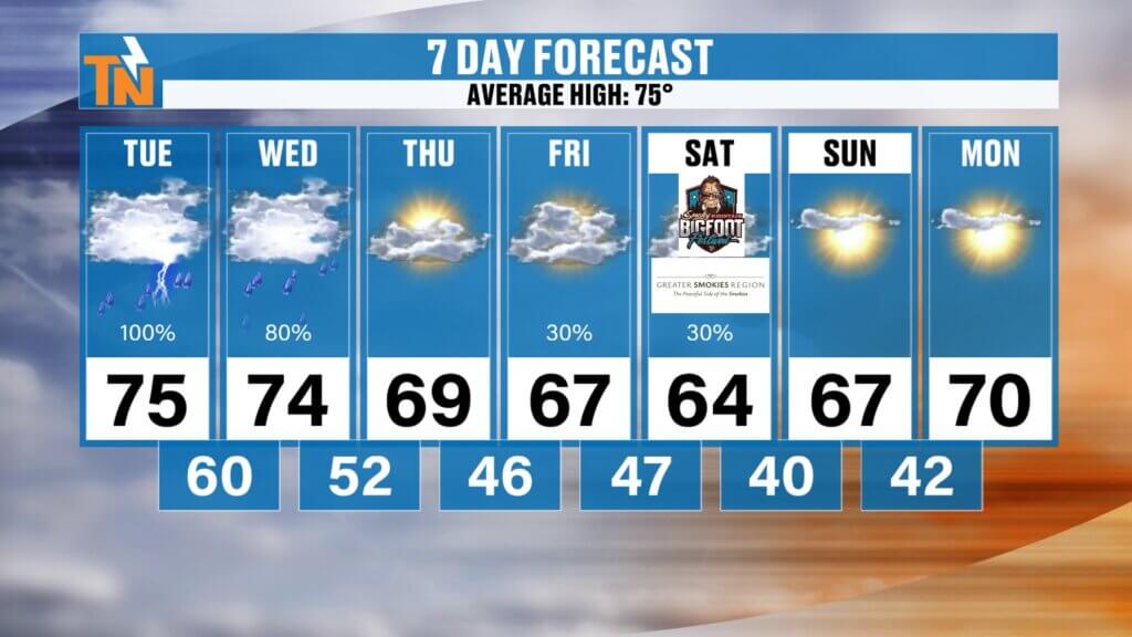
Temperature Trend: Cooling Down
After the storms:
- Tuesday–Wednesday: Mid 70s
- Thursday–Friday: Mid to upper 60s
- Saturday: Mid 60s (coolest day)
Morning lows:
- 40s by the weekend
- Low 40s possible Sunday and Monday mornings
A much cooler air mass settles in as we head toward the first weekend of May.
Late Week Outlook
- Thursday–Friday: Cooler, drier
- Friday–Saturday: Another system may bring additional rain
- Overall trend: Below-average temperatures
Final Thoughts
We’re in the middle of a much-needed wet pattern, but it comes with a few rounds of storms you’ll need to watch closely.
Expect:
- Quiet periods mixed with active weather
- Storms tonight and again Wednesday
- Cooler, more comfortable air by the weekend
Stay weather alert tonight, especially overnight while storms move through.
Have a great Tuesday, and keep the East Tennessee weather app handy for real-time updates.
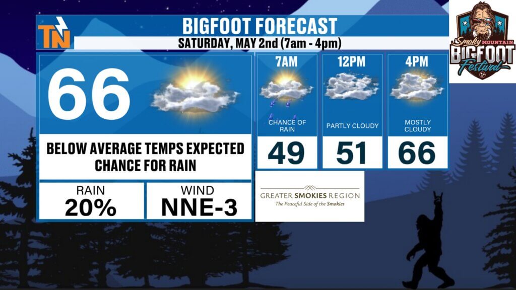
Bigfoot Festival Preview
Looking ahead to Saturday in Townsend:
- Bigfoot Festival: 7 AM to 4 PM
- Highs around 66°
- Morning temps in the 40s
- Slight chance for rain
There’s even a small chance for patchy frost in colder spots early this weekend.
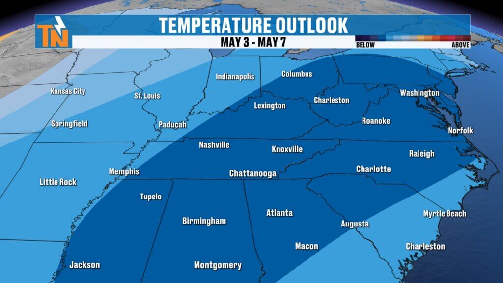
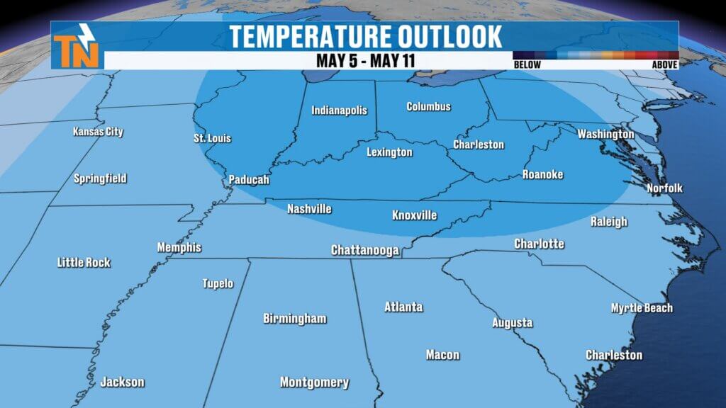
Longer Range Outlook
- Cooler pattern may linger into early May
- Temperatures could stay below average for the first week or two
- Rain chances taper off after midweek
Final Thoughts
Today is your quiet weather window before things turn active. Expect a soggy Tuesday morning, another round of storms late Tuesday, and then a shift to cooler, more comfortable air.
Make sure you’re weather-aware for the Tuesday morning commute and again Tuesday night.
Have a great Monday, and don’t forget to track it all on the East Tennessee weather app.