
Published: Thursday, November 12, 2026 | By Meteorologist Mike Witcher | eastTNweather
Good morning, East Tennessee, and happy Thursday! Thanks so much for checking in with your morning weather update on this November 12th, 2026.
The changes we’ve been talking about for about a week now move in today. We’re talking about significantly cooler weather today and through the upcoming weekend, some light rain showers, and yes, mountain snow. We currently have a winter weather advisory that’s been issued by the National Weather Service.
So let’s walk through all of those details, because the big question is who sees flakes and who sees accumulation.
Yesterday's Almanac: The Last Warm Day
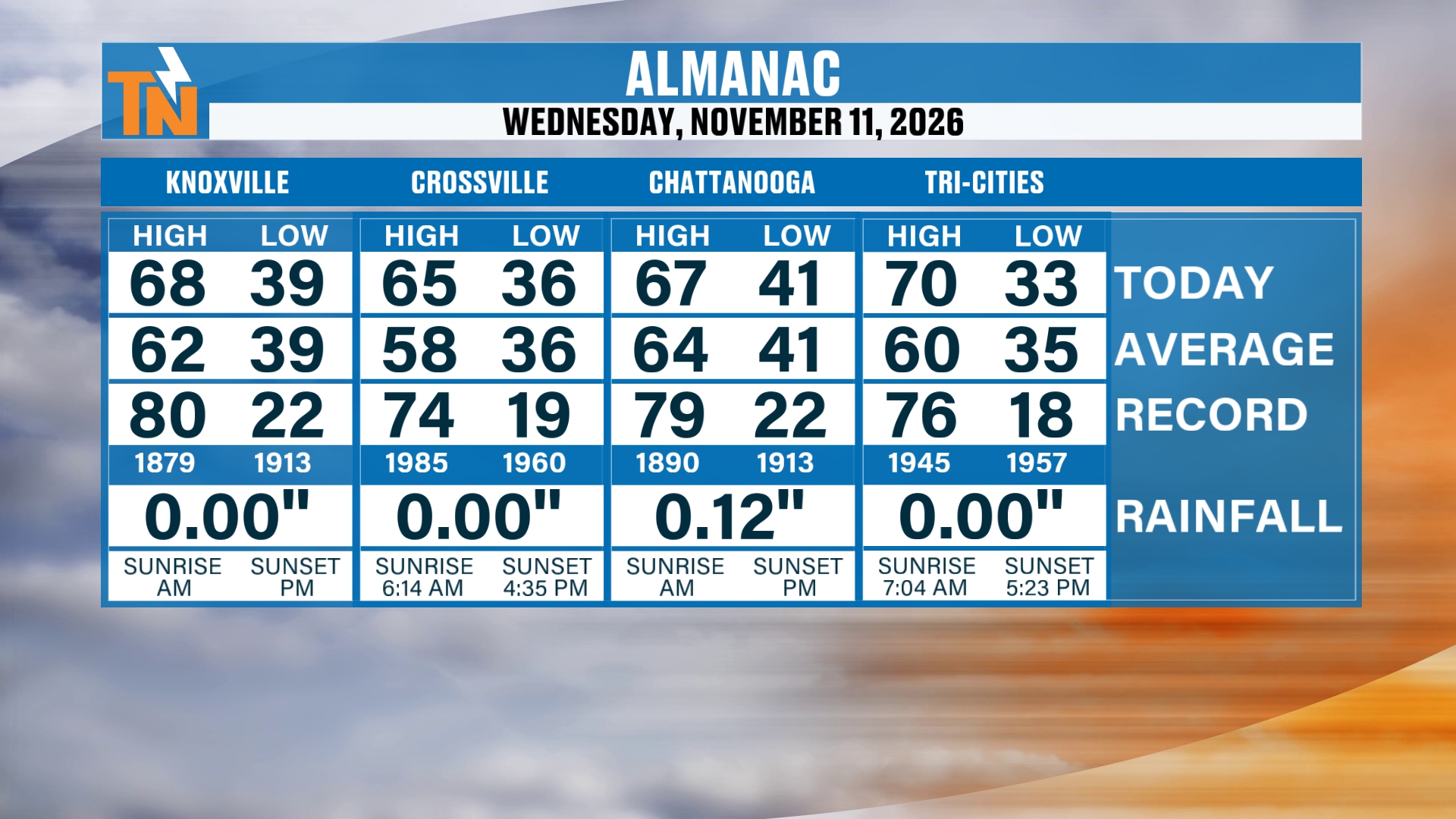
We’ll start with the almanac from yesterday. Why? Because it was the last warm day that we’re going to have, at least in the short term.
We made it to 68 degrees in Knoxville. Crossville reached 65, Chattanooga hit 67, and the Tri-Cities topped out at 70.
The Cold Front Already Came Through
We’ve already had a cold front swing its way on through. The Storm Prediction Center issued a level one risk for severe weather late last night.
Now, we didn’t see a lot of severe weather, but we did see a batch of rain move its way on through. Not many of the models were picking up on that line of showers and thunderstorms last night, so that was a little bit of a surprise. I didn’t think it was going to hold together, but it sure did as it moved through the area.
So we’ve got some wet roads out there this morning, especially across the Tri-Cities area. Other than that, there are a couple of lingering showers, and I think that’s really going to be the story today.
Not a whole lot of rainfall throughout the day, but a couple of spotty showers in that westerly, northwesterly flow. It picked up a decent amount of rain in some locations, and that’s much needed by all means.
Today's Futurecast: Mostly Cloudy and Breezy
Let’s pick up our Futurecast this morning and run through the day. We’re going to stay mostly cloudy, and the wind is going to be with us. It’ll be a little breezier throughout the day, but mostly dry from now through noon.
I can’t rule out a couple of spotty, stray showers as we get into the afternoon. You can see that northwesterly flow setting up shop as another batch of energy and moisture moves through this evening and overnight tonight.
That’s going to lead to more rain, and the potential for that colder air to swing into the area. The colder air comes through overnight tonight into Saturday morning, at which point we start to see the transition from rain to mountain snow across the higher elevations.
Just through the night tonight into tomorrow morning, we’re not talking about a lot of rainfall, and we’re not talking about a lot of snowfall. But we do have that winter weather advisory.
The Winter Weather Advisory
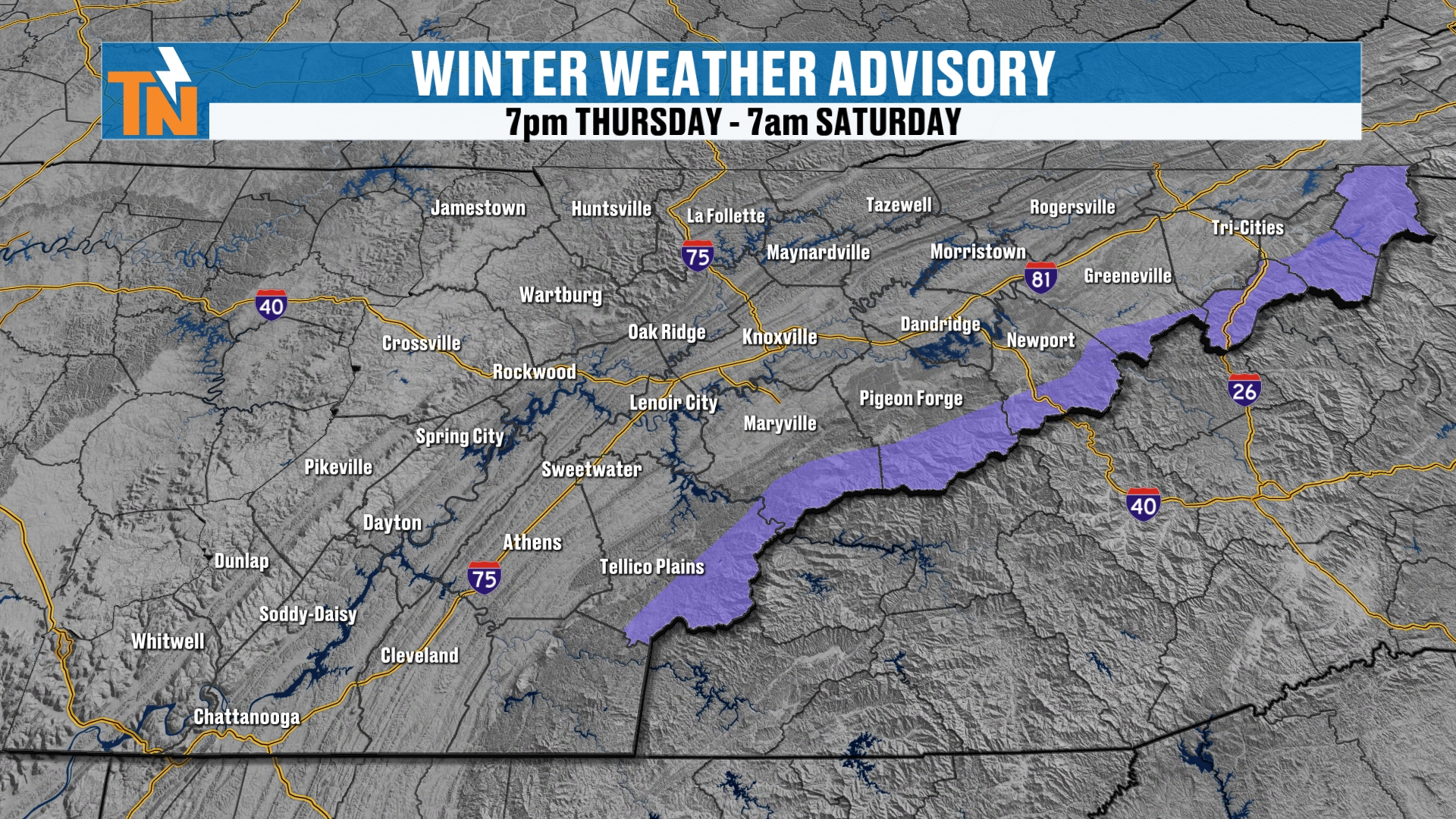
The advisory goes into effect at 7:00 tonight and runs through 7 a.m. on Saturday. It includes elevations of 3,000 feet or higher. So 3,000 feet or higher is where the winter weather advisory takes shape.
Let’s walk through the day today, and then we’ll continue our forecast overnight tonight and talk about the snowfall potential.
A Mild Start This Morning
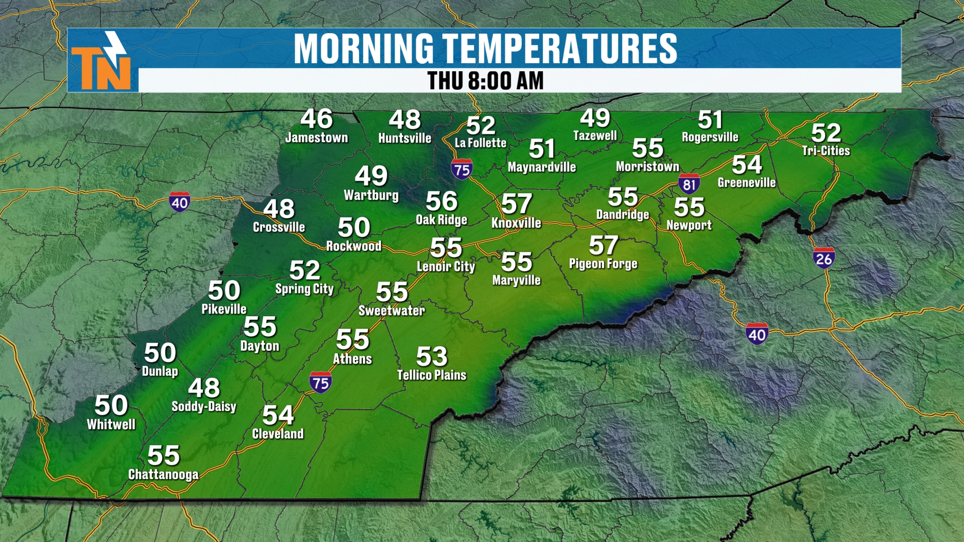
We start off nice and mild this morning, with temperatures in the 50s. That’s well above average for this time of the year.
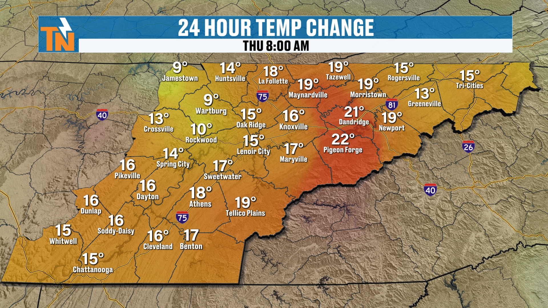
It’s also much warmer than yesterday morning, by about 15 to 20 degrees. So it’s a nice, quiet start to the day.
Today: Steady Temperatures, Breezy Afternoon
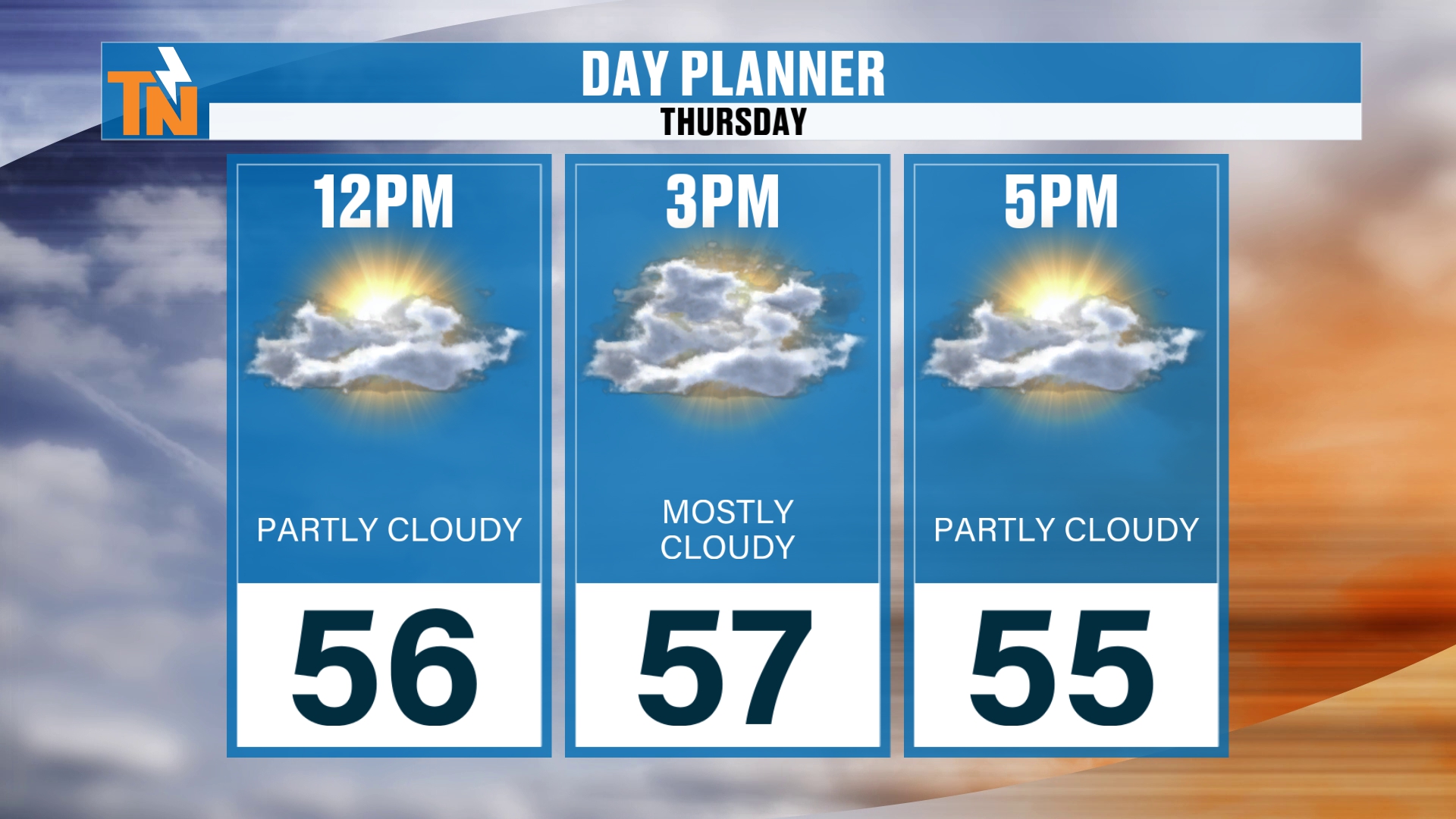
Temperatures are going to stay fairly steady throughout the day. We’ll see 56 by noon, and 57 as the kids head home from school.
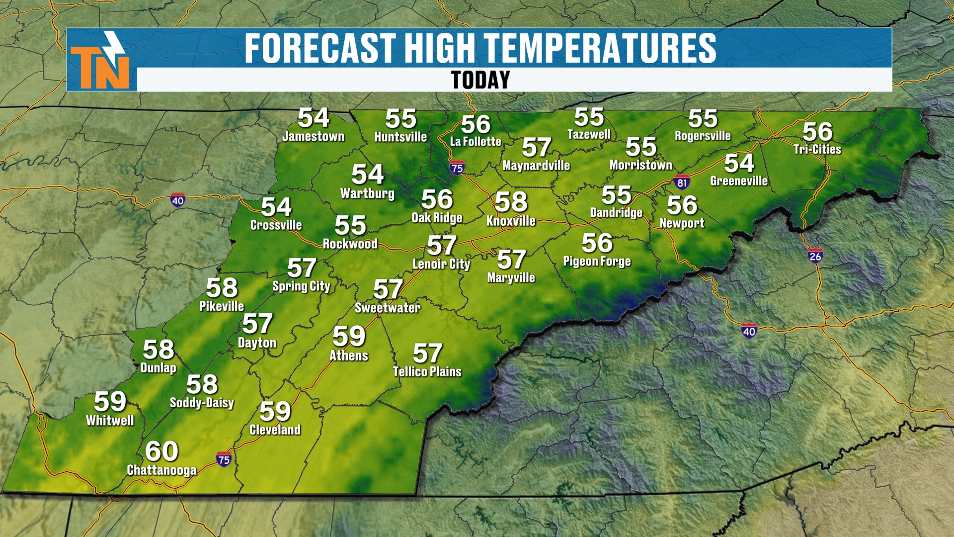
Our goal today is the mid to upper 50s. So again, not much of a warm-up throughout the day.
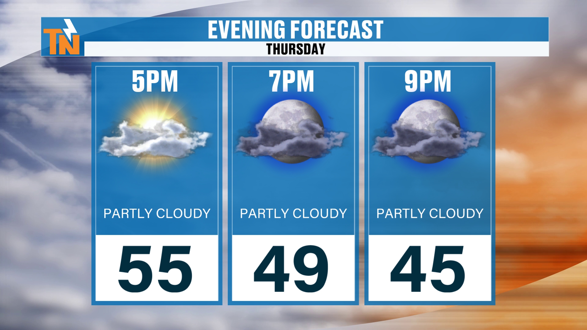
Temperatures won’t fall too quickly this evening, but by 7 PM we’re down to 49. And by 9:00, if you’re still out and about, we’re down to about 45 degrees.
Those peak winds are going to be gusting to about 15 to 25 mph at times, so it’ll feel a little breezy out there throughout the day.
Overnight: Rain Changes Over to Mountain Snow
Let’s continue our Futurecast overnight tonight. That’s when the colder air comes in aloft, and that’s when we start to see some of this rain change over to mountain snow.
There’s not going to be a ton of precipitation, but we will add up a little bit more in the form of light rain showers and the potential for some light snow showers.
Maybe a couple of flurries here or there across the northern plateau overnight tonight into early tomorrow morning. Light accumulating snow is possible tonight into our Friday morning.
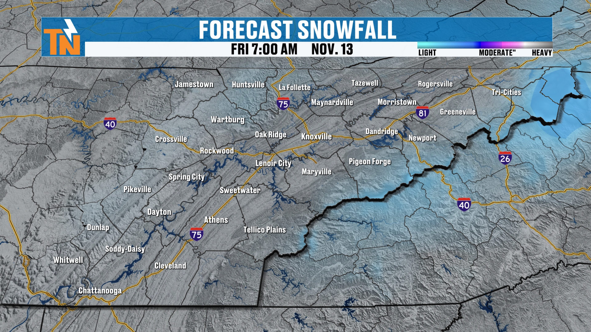
By Friday morning, the light snow is focused along the higher terrain on the Tennessee and North Carolina border.
Friday: Drier, Then Another Wave Arrives
But it’s not done. Let’s continue our Futurecast and take you all the way through the day on Friday.
I think the majority of the day is probably going to be on the drier side. But as we get into the afternoon and evening, here comes another wave of energy, shooting in another shot of colder air and even more moisture.
I think that’s going to be the story. We’re going to see a few more flurries by the end of the day on Friday, and more snow showers will be increasing Friday night into Saturday morning.
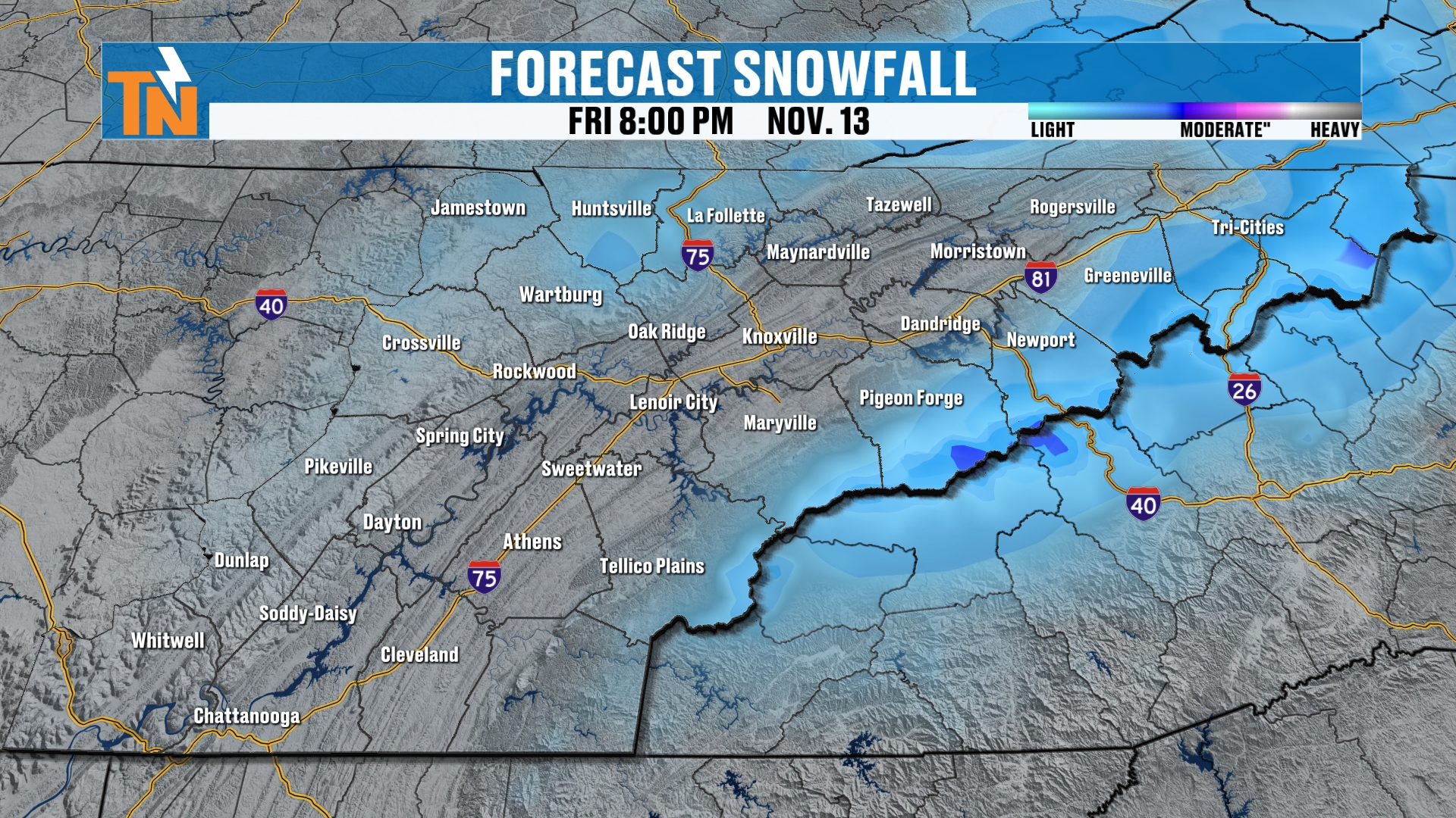
Again, not a ton of moisture and not a ton of precipitation. But a little bit more rain is being added to the forecast, and a little bit more snow as well.
Saturday Morning: The Snow Machine
The storm system doesn’t wind down until Saturday morning. I think the snow machine is going to be really cranking Friday night into early Saturday morning across the higher elevations, at which point we’ll add up to a little bit more snow.
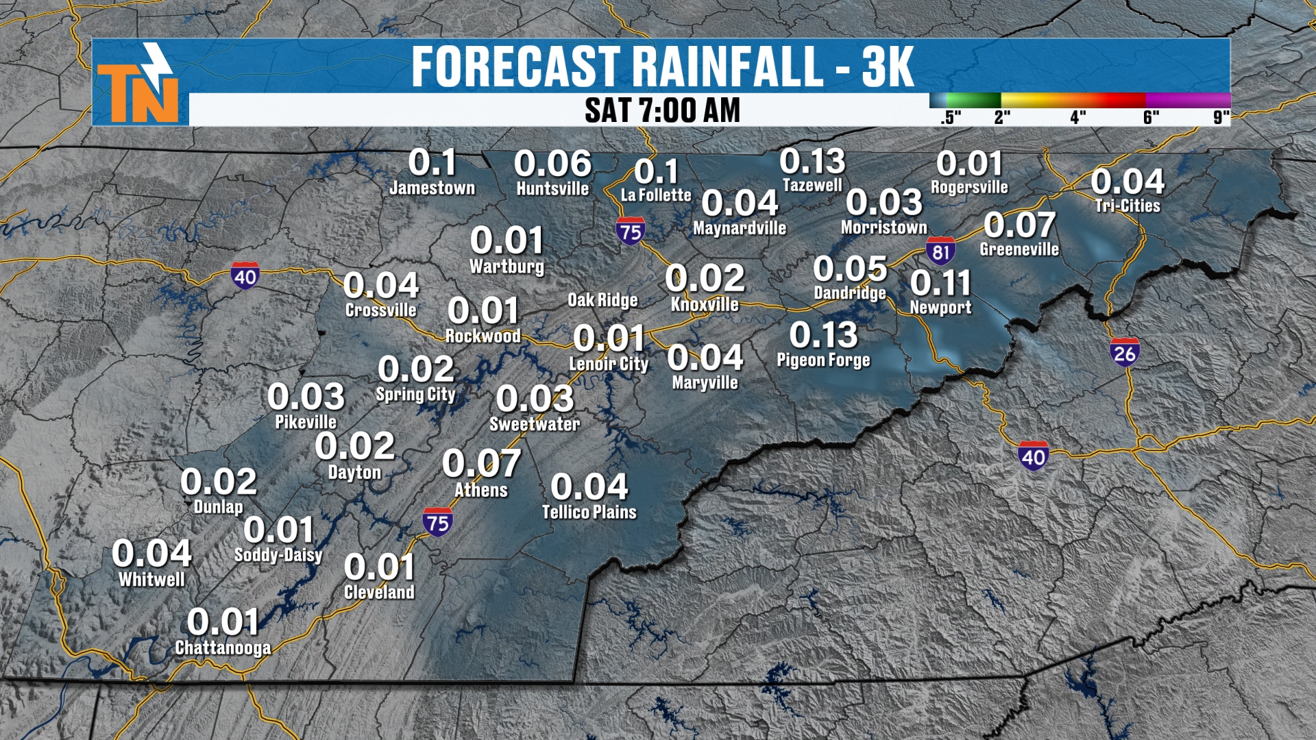
So not a ton more rainfall is expected across the area. Just a couple of spotty, light showers through this entire event. It’s really going to be more of a snow maker across the higher terrain.
How Likely Is Mountain Snow? Breaking It Down
Let’s break things down into different categories, because the chances change a lot depending on how much snow we’re talking about.
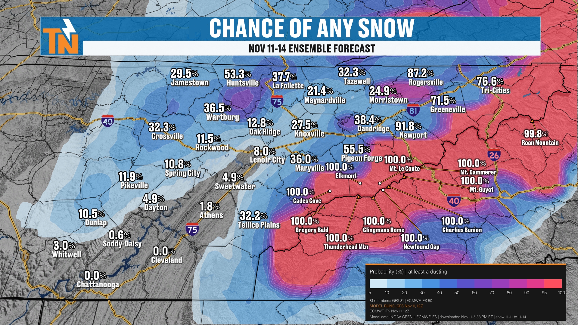
We have a 100% chance for snow to fall across the mountains. That means any sort of snowfall at all. It’s going to fall.
We’ve also got about a 30 to 50% chance for some light snow showers across parts of the northern Cumberland Plateau.
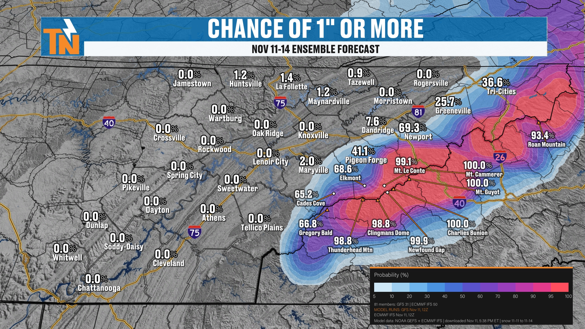
What about a chance of one inch or more? Probably not on the plateau. But we have a good shot of at least an inch of snowfall across the mountains.
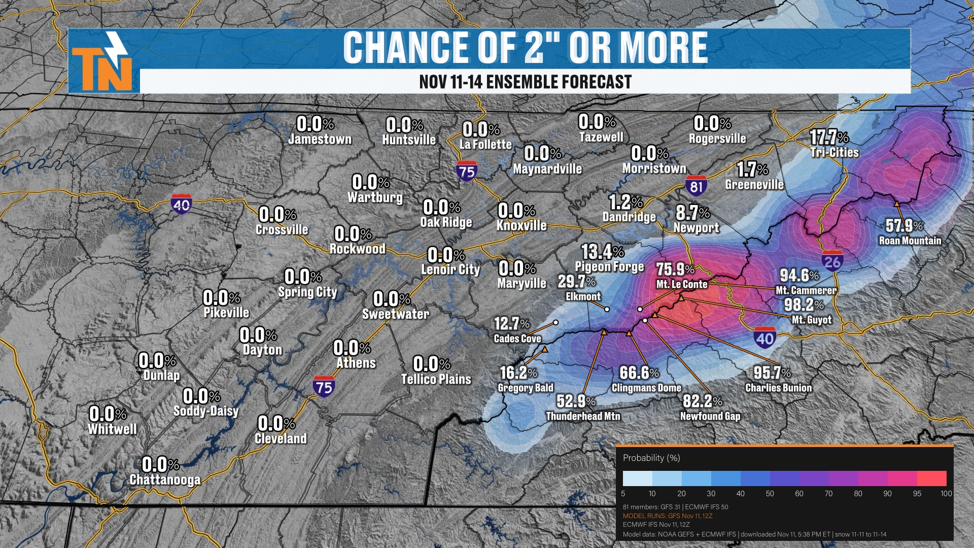
We have a good shot at probably two inches of snowfall across the highest peaks.
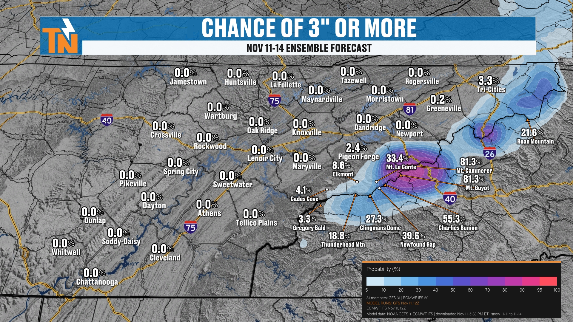
And maybe even three-plus inches of snowfall across some of the highest peaks of the Smokies.
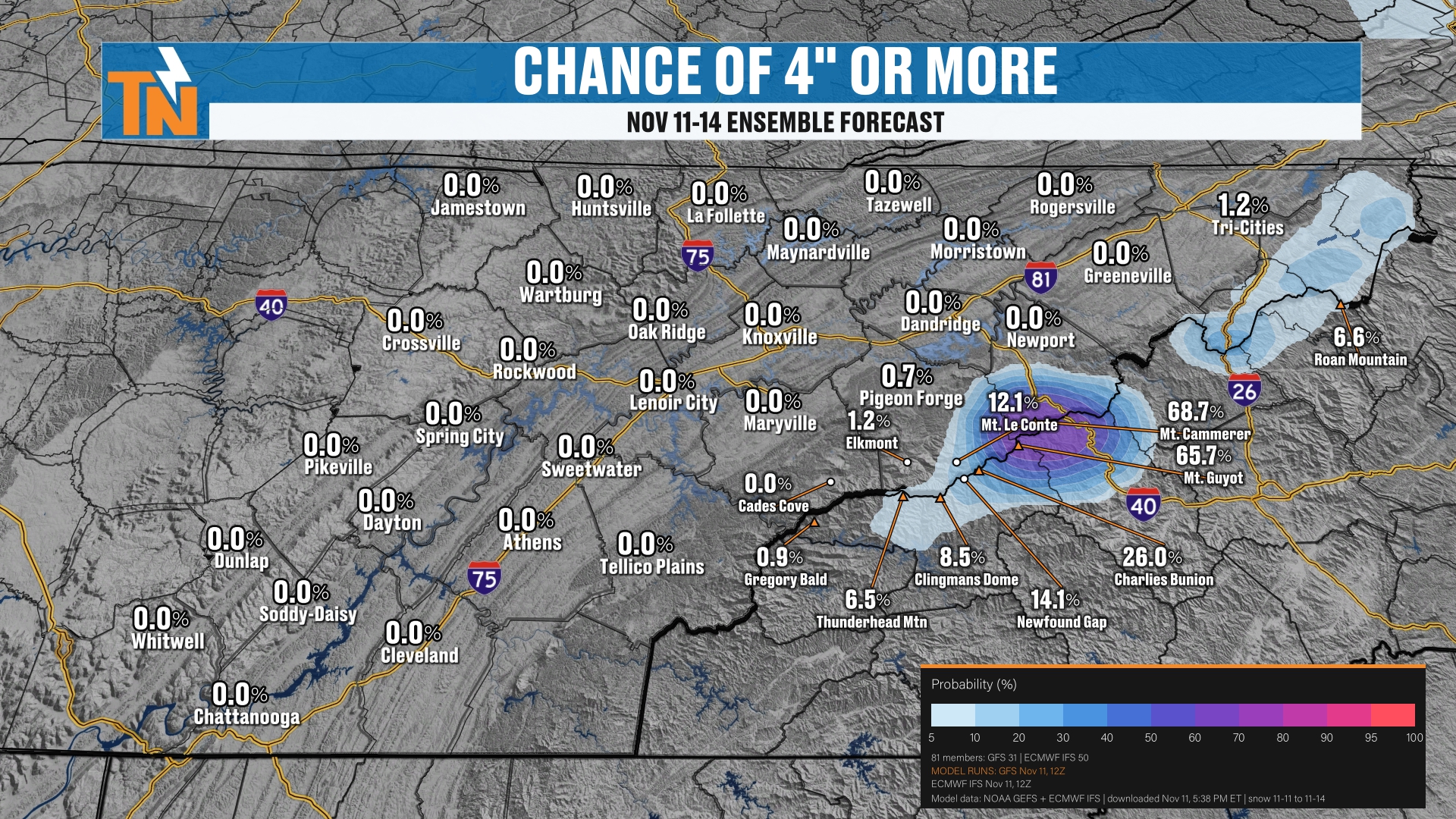
But the higher the snowfall total, the lower the potential. The chance of four inches or more is confined to just a few of the very highest peaks.
The High End and the Low End
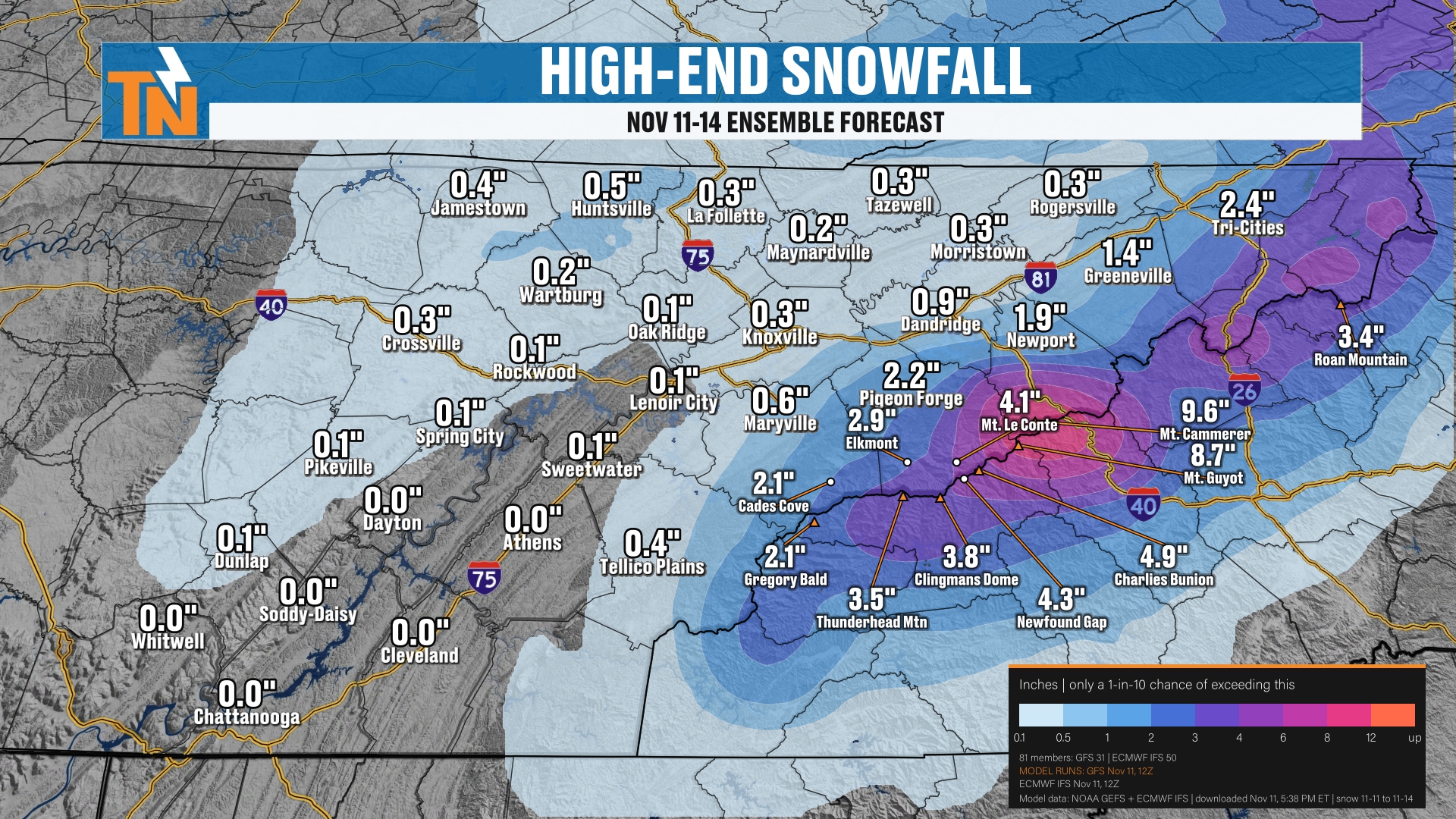
Our high-end snowfall forecast from the ensembles is picking up anywhere from four to upwards of eight or nine inches of snow. That’s the high end.
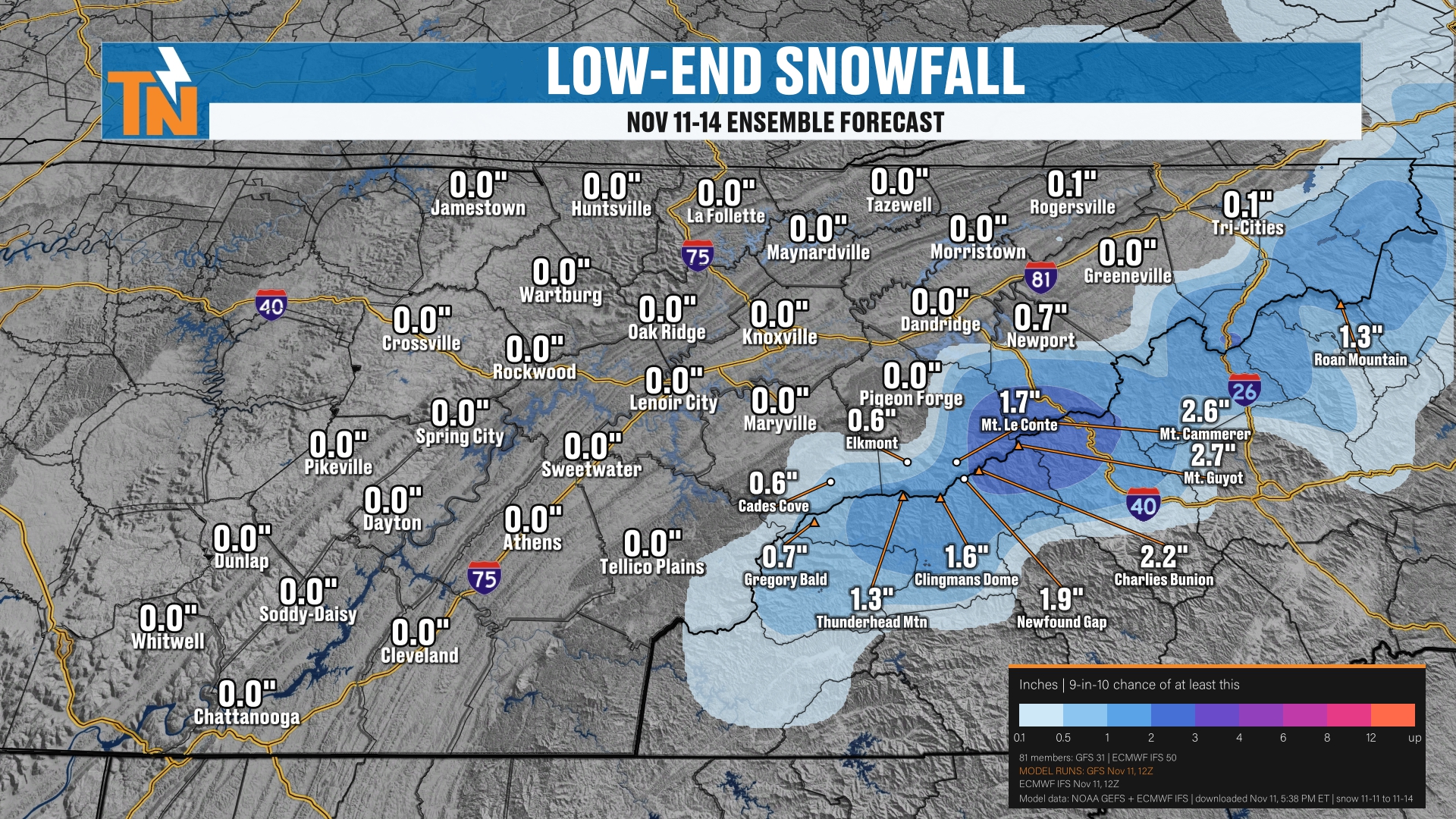
On the low end, we’re looking at anywhere from one to basically three inches of snowfall across the highest peaks of the Smokies.
When you look at the average snowfall per the ensembles, we’re looking at basically two to five inches. And that’s what I think we’re going to see.
My Official Forecast: Flurries on the Plateau, Mountain Snow in the Smokies
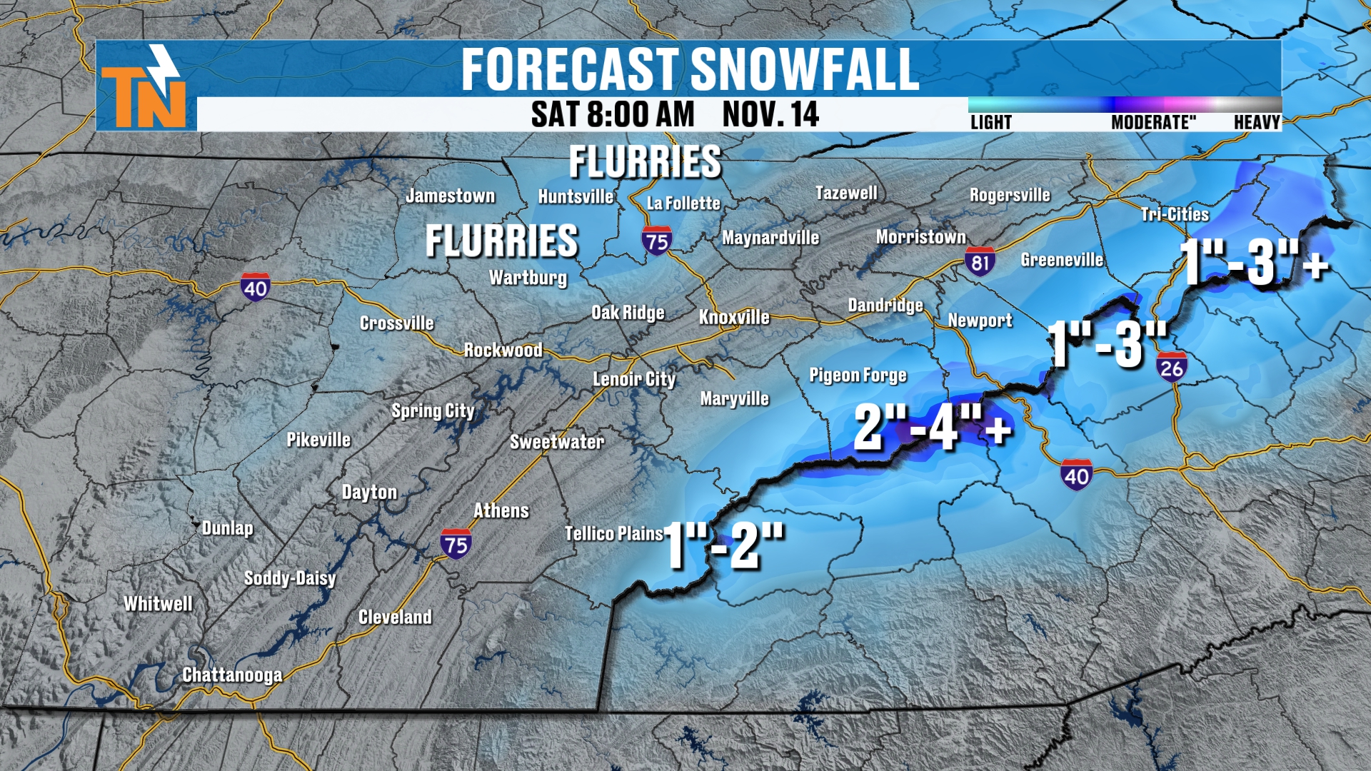
Here’s your official forecast from me. I’m going with flurries across the plateau. Two to four-plus inches across the highest peaks of the Smokies. And one to two inches in other areas of the higher elevations.
Who Sees Flakes in the Lower Elevations?
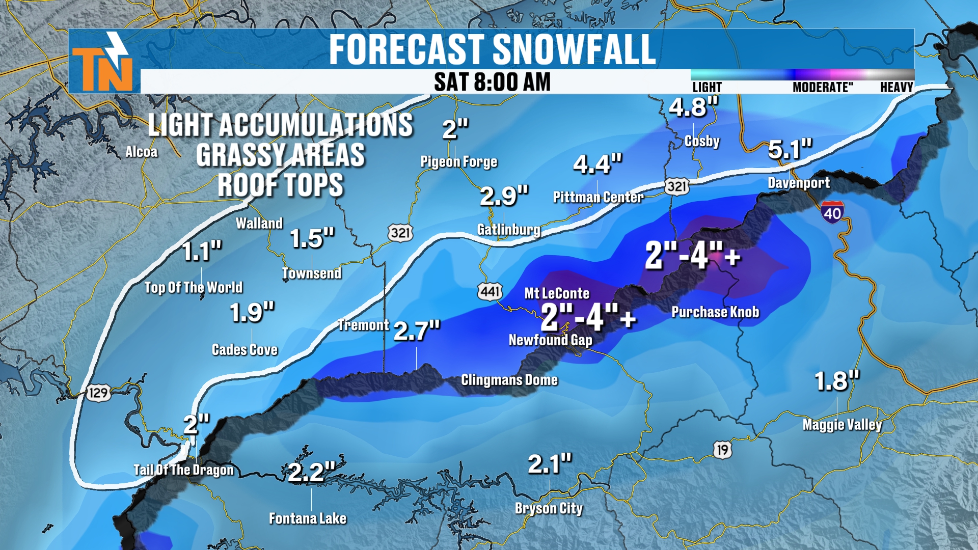
With that said, we also have the potential for some light snowfall down across some of the lower elevations. That includes towns like Cades Cove, Top of the World, Pigeon Forge, Pittman Center, Gatlinburg and Cosby, as well as Newport.
I know I have numbers on the map there, and this is my forecast. Light accumulations are possible, but mainly on the grassy areas and the rooftops. I think that’s about the only thing we’ll see.
Here’s the reason why: the ground temperatures are just too warm. Anything that starts falling in, say, Gatlinburg or Townsend, will it actually measure one to two inches of snowfall? The answer is going to be absolutely not. You don’t get that.
But does it snow in Gatlinburg, Pittman Center and Townsend? I think the answer is possibly yes, at times during this event.
Again, the highest peaks of the Smokies will see anywhere from two to four, or three to five inches, across the area.
Winter Weather Advisory Recap
So, once again, a recap of that winter weather advisory. It covers the mountains of East Tennessee above 3,000 feet, and it runs all the way through Saturday morning. It starts at 7:00 tonight.
Dry Canadian Air and a Hard Freeze
This whole storm system is going to continue to bring in the colder, drier air as well.
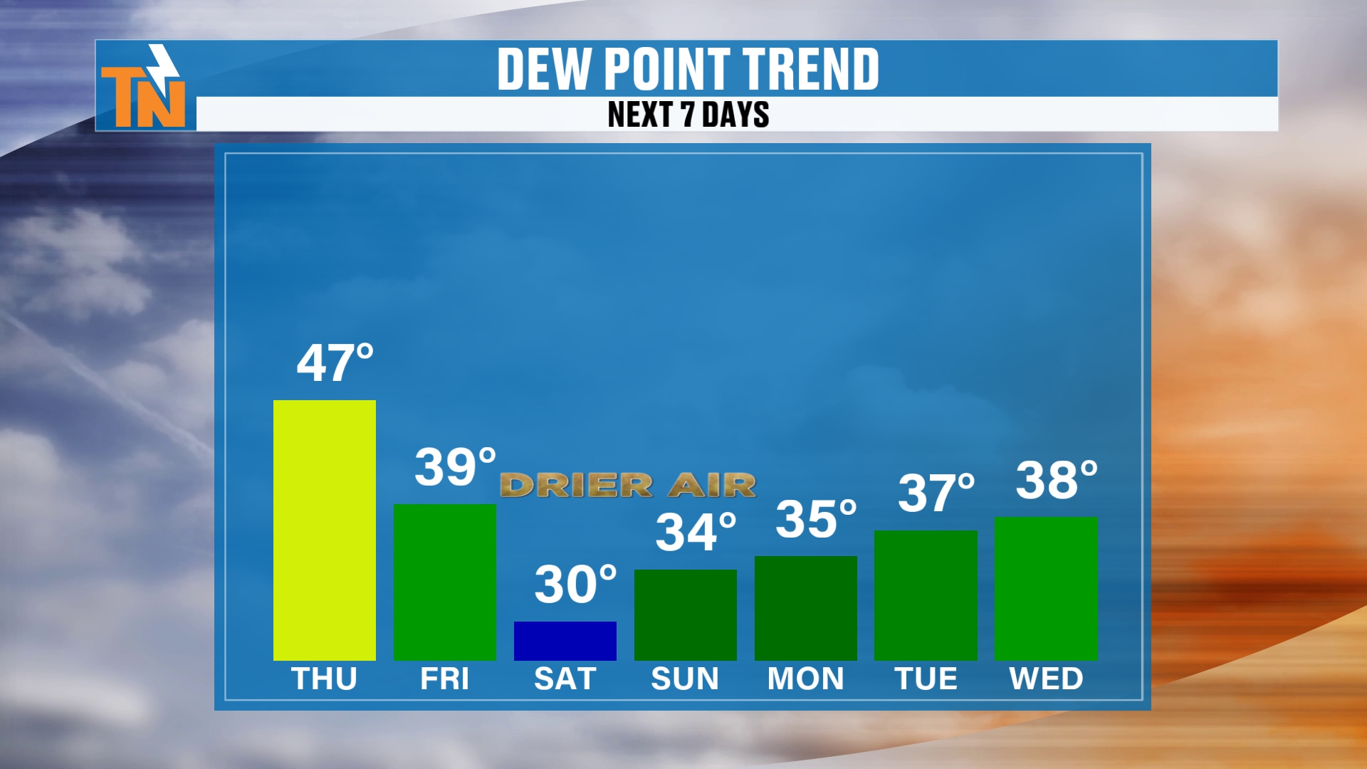
Saturday and Sunday are probably going to be the driest days, with dew points in the 30s. As this cold air comes racing out of Canada, it brings us that dry Canadian air.
So static electricity will increase, by the way, this weekend.
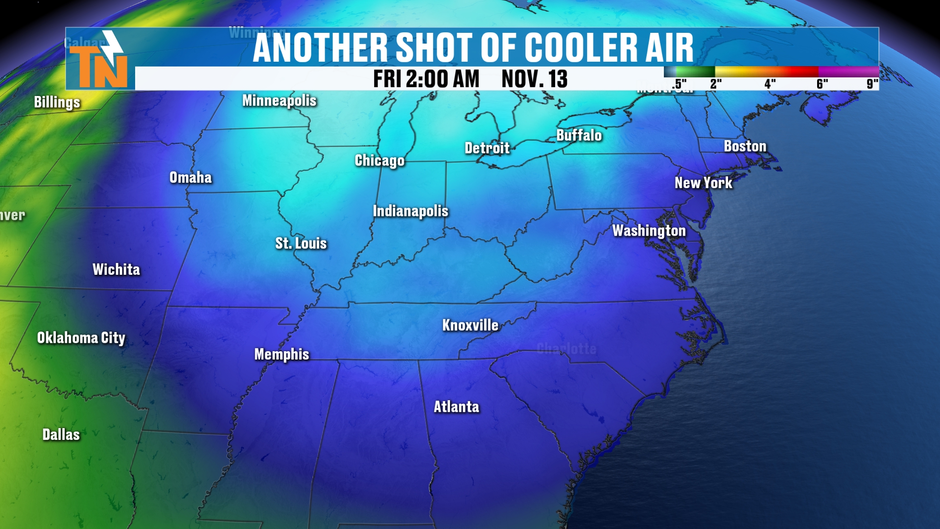
It’s definitely a shot of old man winter, and that’s going to potentially bring us a hard freeze in some locations around the area through the weekend and into the start of next week.
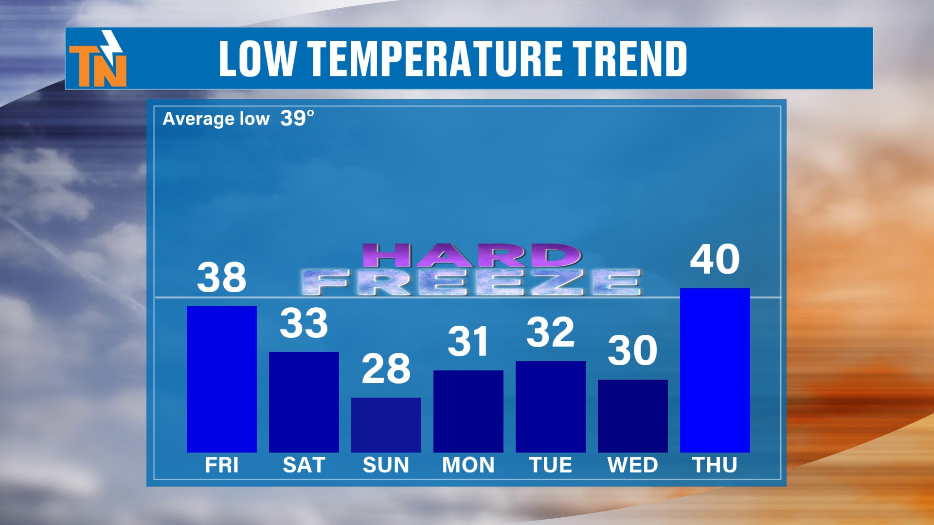
The low temperature trend shows morning lows dipping into the 20s and low 30s through the weekend and into early next week.
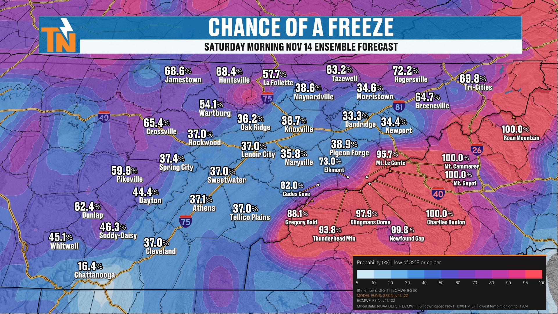
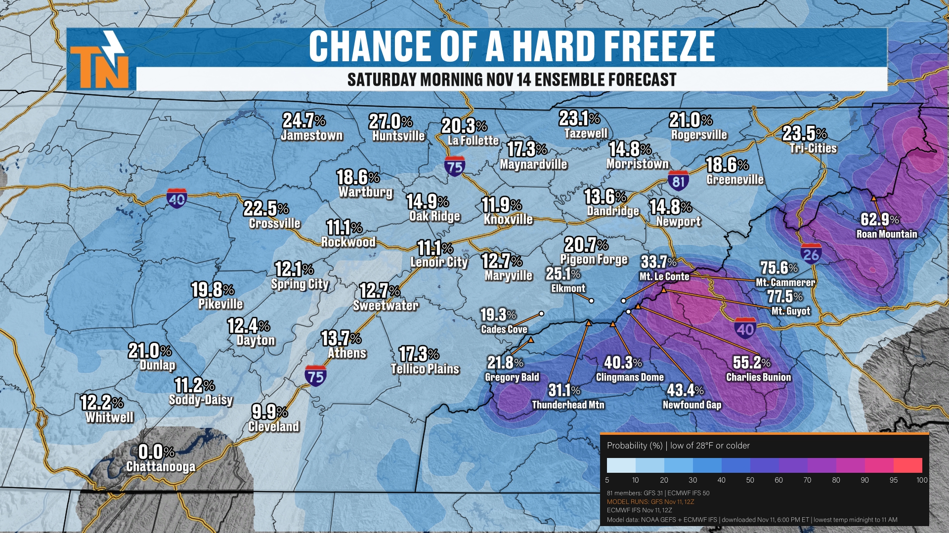
The best locations for seeing a freeze on Saturday morning will be across the plateau. But it’s only about a 20 to 30% chance across the plateau for a hard freeze.
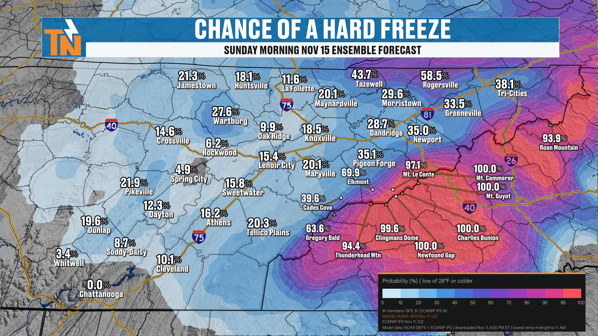
That’s pretty much going to be the story for Sunday morning as well. But we have a better potential for a hard freeze on Sunday morning, in more locations, than on Saturday.
Your 7-Day Forecast
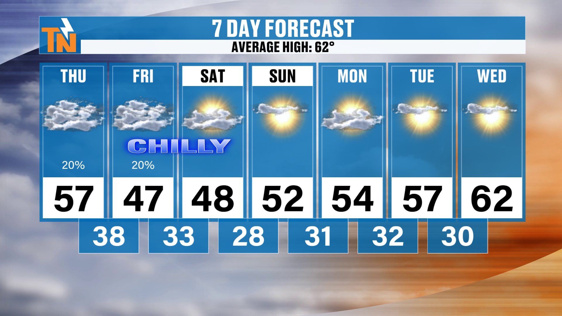
On your 7-day stretch, we’re going to be chilly on Friday and Saturday, with highs in the mid to upper 40s. Then we rebound nicely back into the 50s.
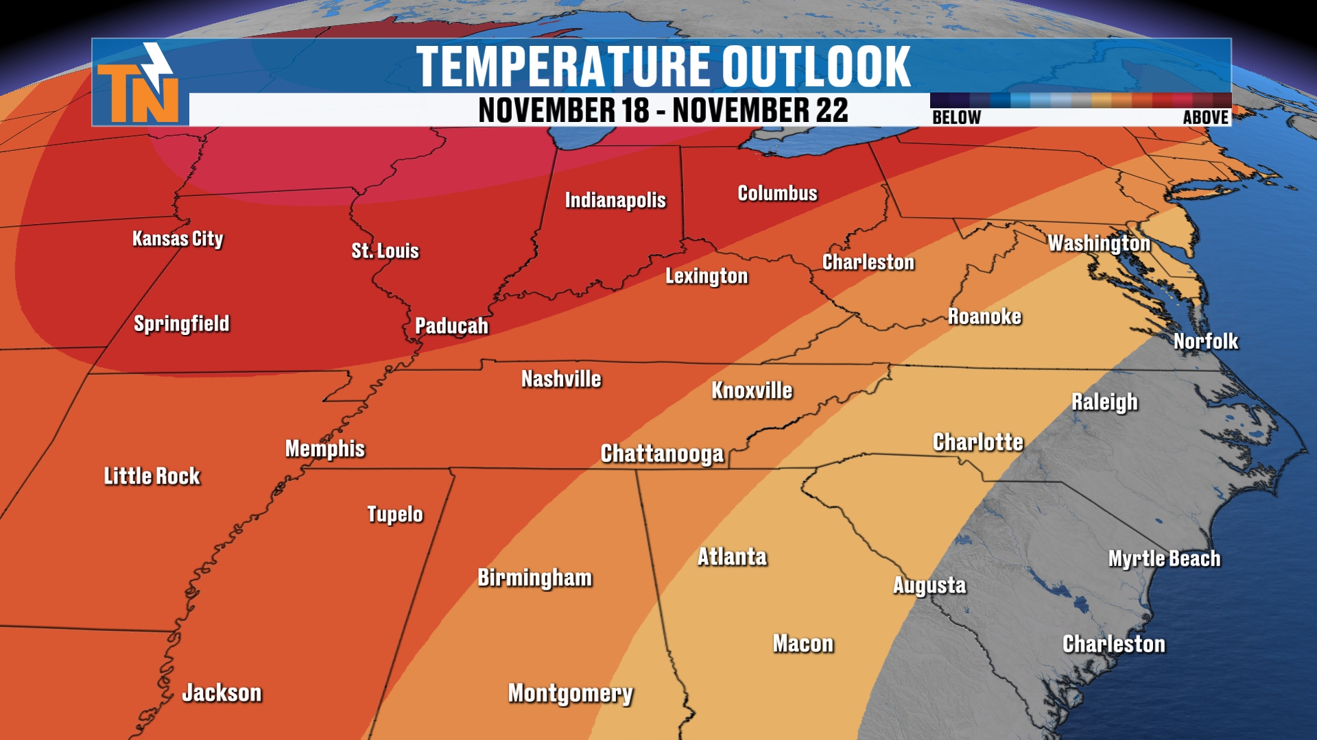
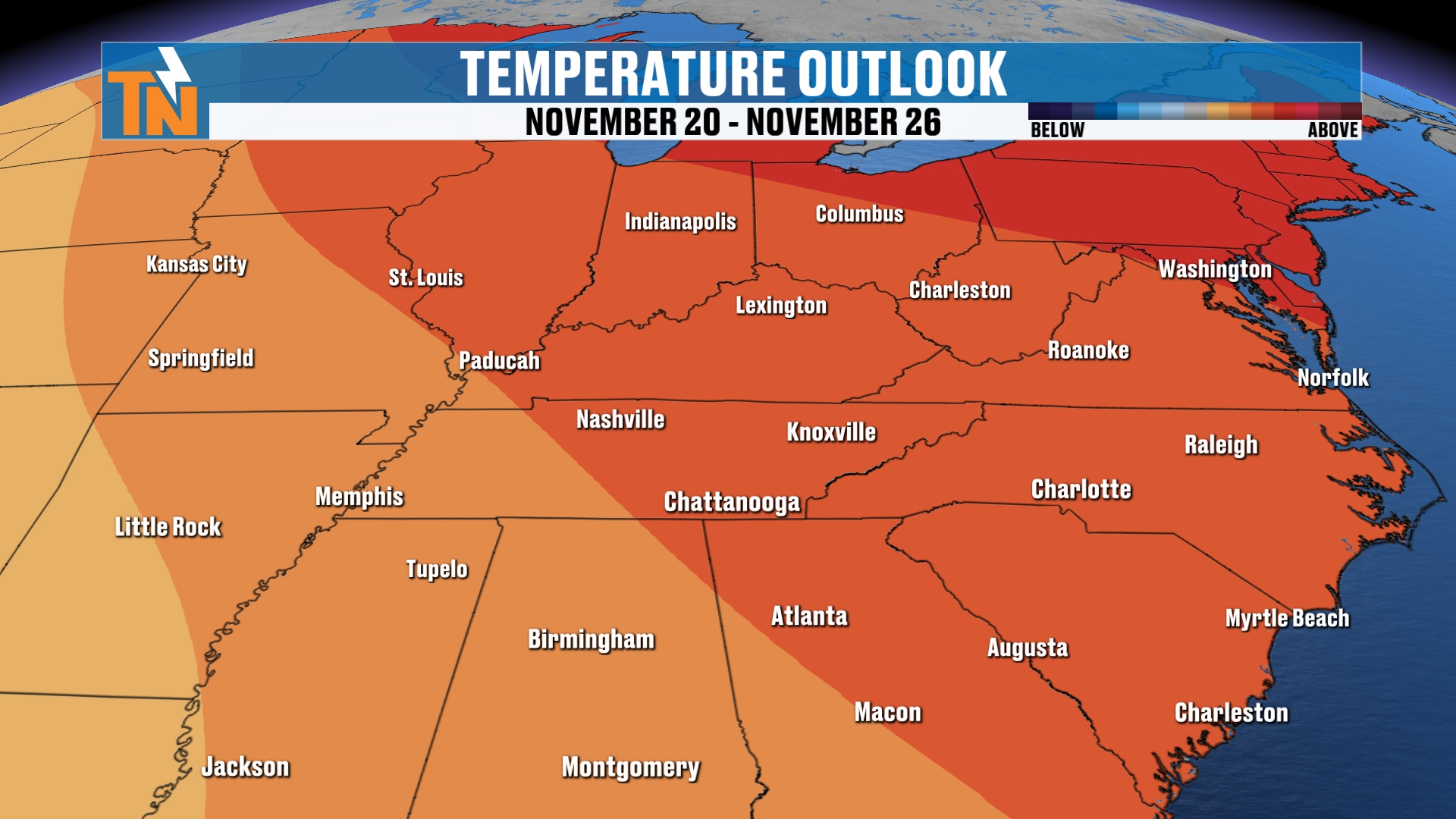
More seasonable weather returns as we get into Wednesday and Thursday of next week. At that point, the Climate Prediction Center has been talking about above-average temperatures sliding their way back into the area.
Bottom Line
THURSDAY (TODAY): Mostly cloudy and breezy, with a mild morning in the 50s. 56 at noon, 57 as the kids head home, a high in the mid to upper 50s, and gusts of 15 to 25 mph. A couple of spotty showers possible this afternoon. 49 by 7 PM and about 45 by 9 PM. The winter weather advisory begins at 7 PM for elevations of 3,000 feet and higher.
THURSDAY NIGHT: More rain and colder air arrive. Rain changes to mountain snow in the higher elevations. Maybe a few flurries across the northern plateau.
FRIDAY: Mostly drier during the day, chilly with a high in the upper 40s. A few flurries by the afternoon and evening as another wave of colder air and moisture arrives, then snow showers increase Friday night.
SATURDAY: Chilly, with a high in the upper 40s. The advisory ends at 7 AM. Mountain snow winds down, the air is dry with dew points in the 30s, and a hard freeze is possible, with only about a 20 to 30% chance on the plateau.
SUNDAY: Dry, with a better chance of a hard freeze in more locations than Saturday.
MONDAY THROUGH TUESDAY: Temperatures rebound into the 50s, with chilly mornings.
WEDNESDAY AND THURSDAY: More seasonable weather returns, with above-average temperatures expected to slide back in.
The takeaway: flurries on the plateau, two to four-plus inches on the highest peaks of the Smokies, one to two inches in other higher elevations, and light accumulation on grassy areas and rooftops in a few lower spots like Gatlinburg, Pittman Center and Cosby. Don’t expect big measurable totals in the towns.
For more daily updates, check out our Daily Forecast page.
Don’t forget to LIKE, SHARE and SUBSCRIBE to the YouTube channel and hit the bell at the top. It really helps get us out in the algorithm and lets more people know that I’m producing weather every single day on East Tennessee Weather.
Make sure you download my free East Tennessee Weather app. Just go to your app store and search East Tennessee Weather. It’s a wealth of weather information. If you happen to be in any sort of watch or warning, you’ll get a notification, and you’ll also be notified when lightning is within 15 miles of your current location. Not that we’re talking about a ton of lightning, but when there is, the app will let you know. It’s a great tool to have in your toolbox.
I’m Meteorologist Mike Witcher. Have a great Thursday!
eastTNweather — Weather When You Want It.