
Published: Wednesday, November 11, 2026 | By Meteorologist Mike Witcher | eastTNweather
Good morning, East Tennessee, and happy Wednesday! This is your morning weather update on this November 11th, 2026. It’s a nice, gorgeous, quiet, chilly start to the day, and it’s going to turn out to be another fantastic day, just like yesterday.
But old man winter is heading our way. We’ve got a cold front, mountain snow showers, a few flurries along the northern plateau and a hard freeze on the way.
Let’s start things off with a beautiful sunrise taking shape in Harrogate. That’s Lincoln Memorial University’s campus, right up along the Cumberland Gap on the Tennessee-Kentucky border. It’s going to be a great shot during the winter season, as we’ll be able to see a little bit more snowfall falling around that part of town.
Yesterday's Almanac
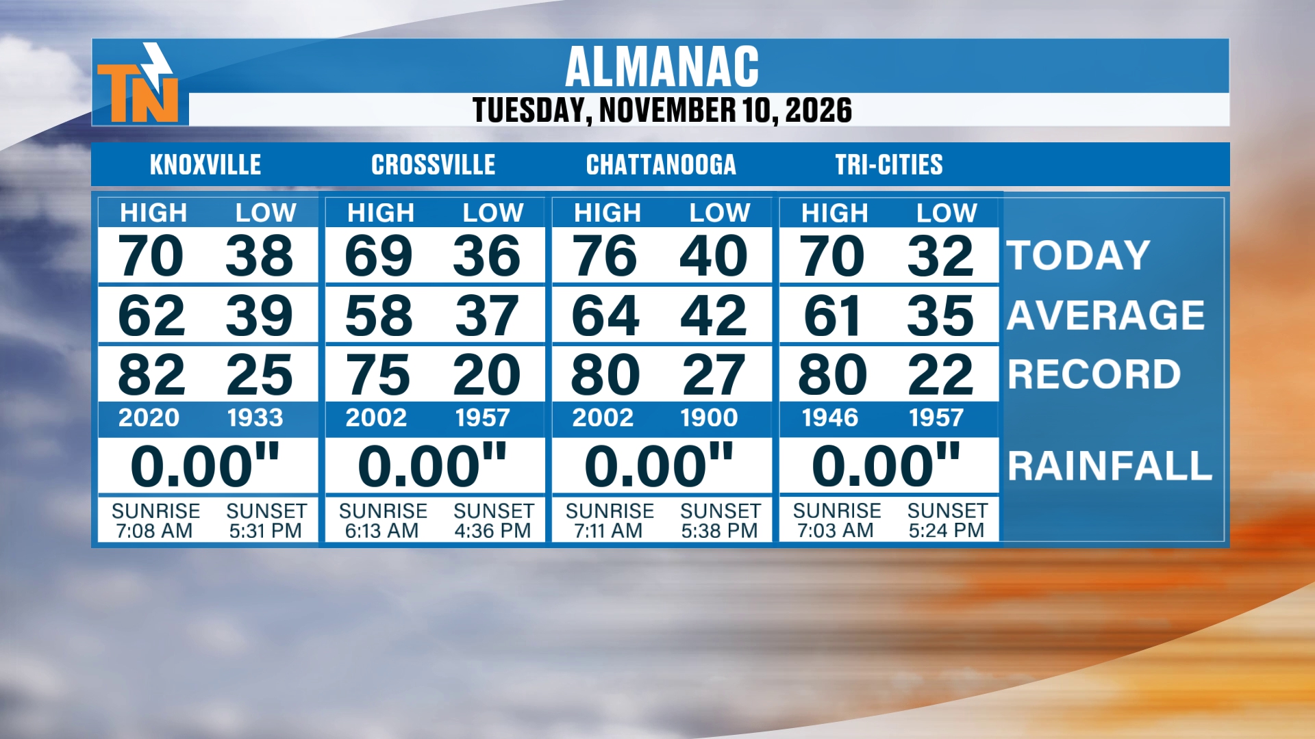
It was another gorgeous day yesterday. By the way, 70 degrees was the high in Knoxville. Crossville reached 69, Chattanooga hit 76, and the Tri-Cities topped out at 70.
The almanac shows lows of 38 in Knoxville, 36 in Crossville, 40 in Chattanooga and 32 in the Tri-Cities. No measurable rainfall at any of the four.
Don’t forget to like, share and subscribe to the YouTube channel, and hit the bell at the top if you’re new. Make sure you stay on top of the latest weather forecast, because we do have some changes on the way.
Our Next Cold Front
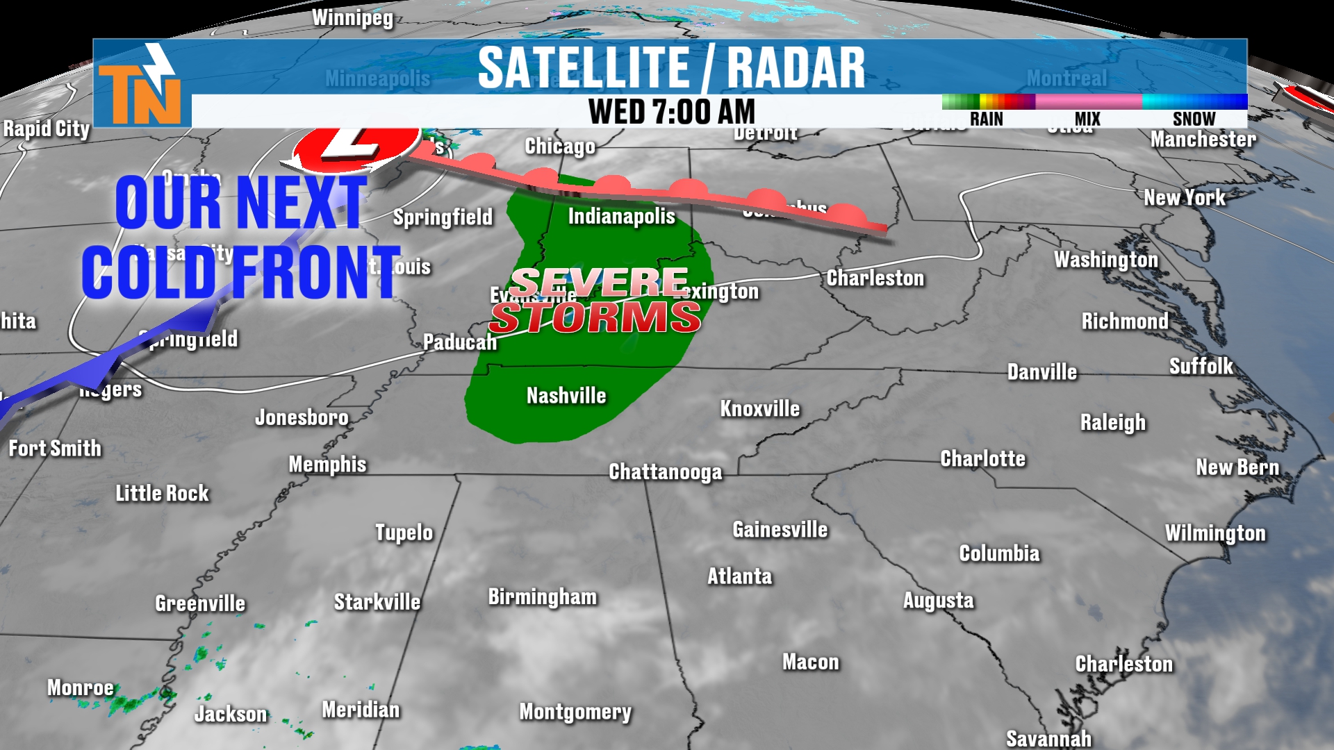
We’ve got our next cold front just off to our north and northwest. It’s going to spill in some severe storms over toward Nashville, Indianapolis, Lexington, Louisville and Evansville, Indiana. The Storm Prediction Center has issued a level one risk there.
Now, when it comes into our area, it’s not going to have this severe weather potential. But it is going to bring us some rain showers.
This frontal boundary is also going to bring us a couple of shots of much colder air. We start that process tomorrow. So that’s another good reason to get out and enjoy some sunshine and temperatures in the 70s today.
Old Man Winter Arrives This Weekend
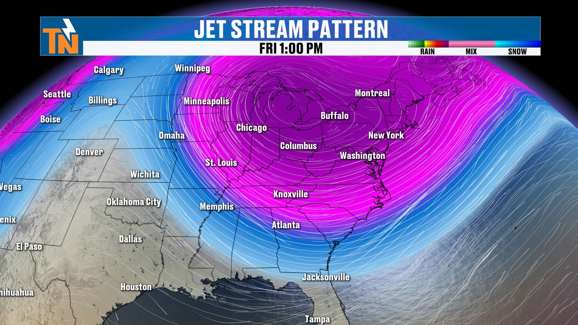
With this pocket of colder air, as we’ve been talking about all week long, we do have the chance for some mountain snow showers, and maybe a few flurries along the northern plateau. That classic horseshoe kind of snow shower activity is possible.
It’s a taste of old man winter heading our way as we get into the upcoming weekend. Friday and Saturday are going to be even chillier than what we’ll experience today and tomorrow.
Chilly Start This Morning
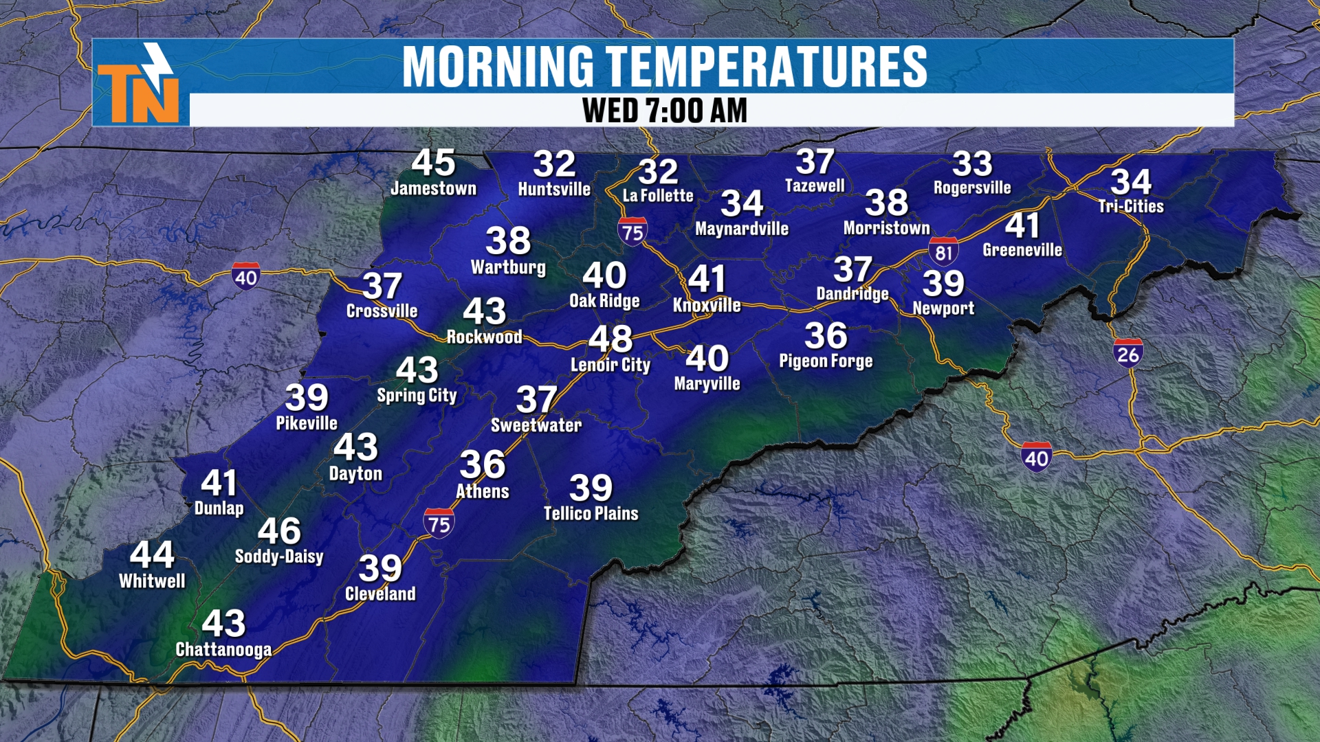
Speaking of today, let’s start you off with low temperatures this morning. We are in the 30s and 40s.
We’ve got some areas of fog and a little bit of frost out there. Not a ton. We’re going to have more widespread frost, and a hard freeze, heading our way as we get into the upcoming weekend.
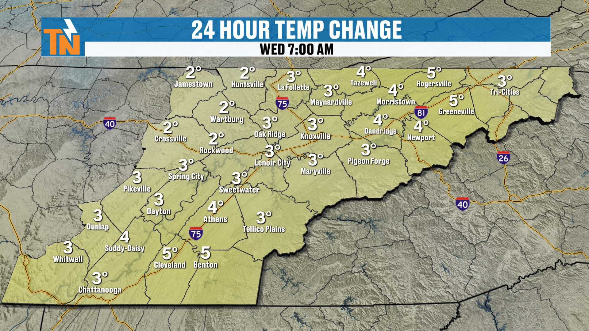
This morning’s temperature change shows we’re running a little bit warmer than yesterday.
Today: Another Fantastic Day
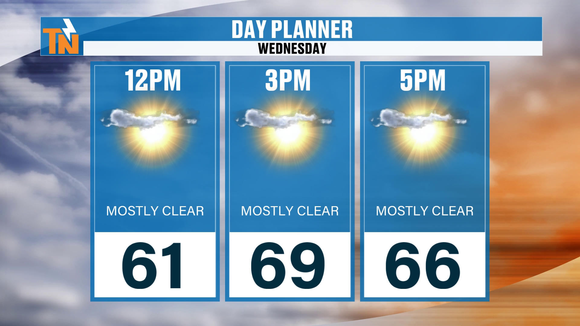
Lunchtime temperatures will be in the low 60s, so a fantastic lunch hour. The day planner shows 61 at noon.
Plenty of sunshine, maybe a few high, thin clouds, and a little bit of an afternoon breeze.
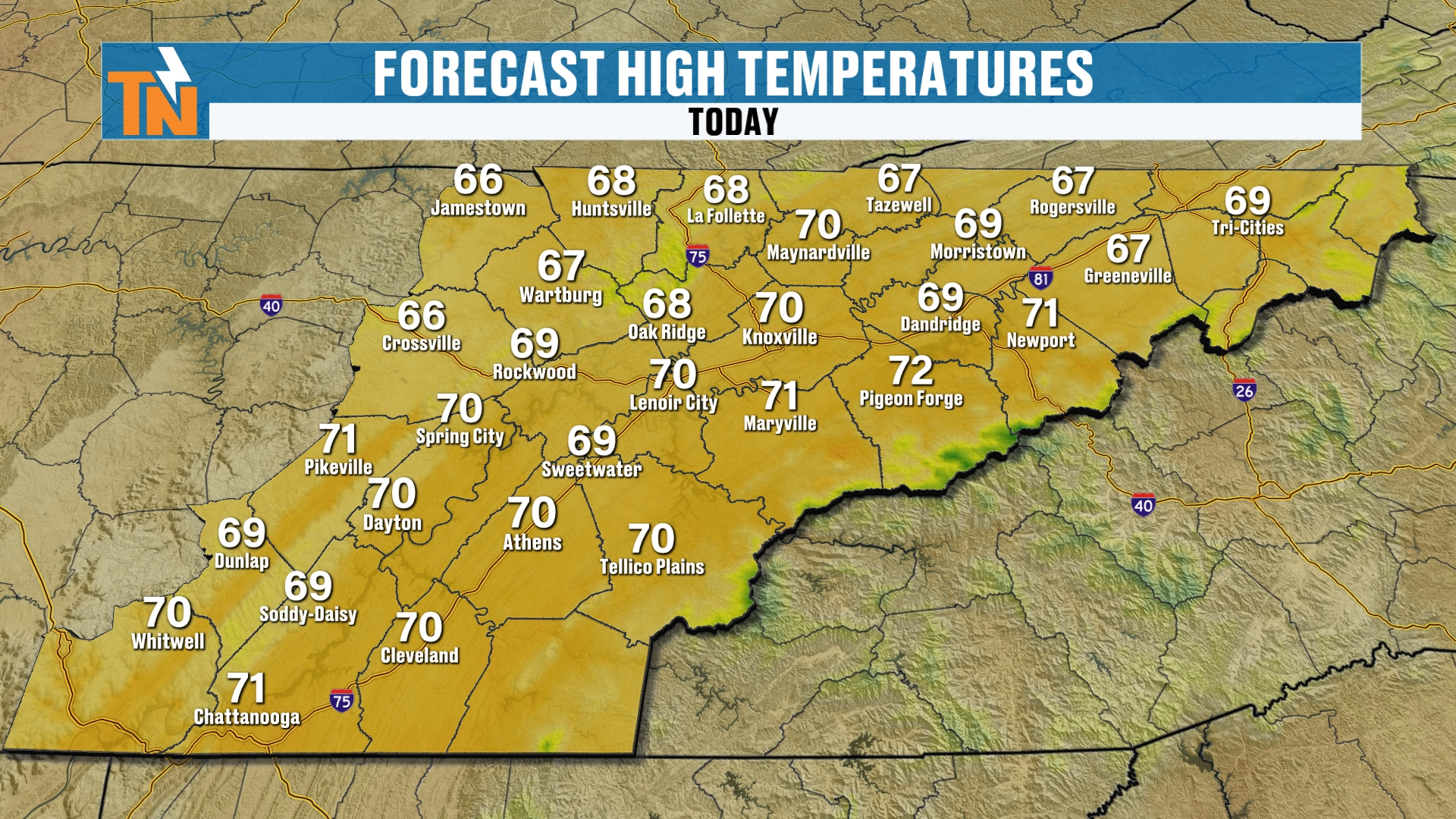
Temperatures top out in the upper 60s to low 70s. So very similar to what we had yesterday.
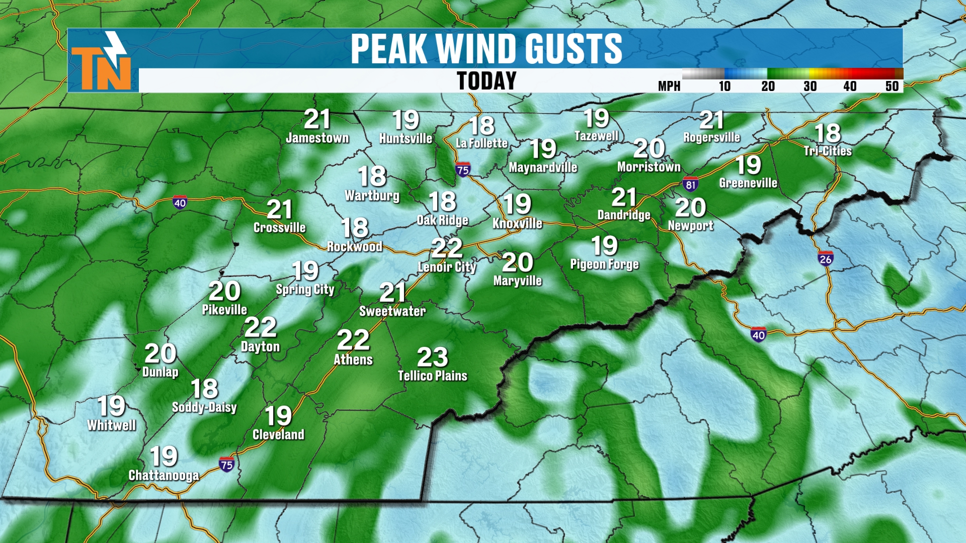
That little afternoon breeze shows up on the wind gust map, with gusts mostly in the upper teens and low 20s.
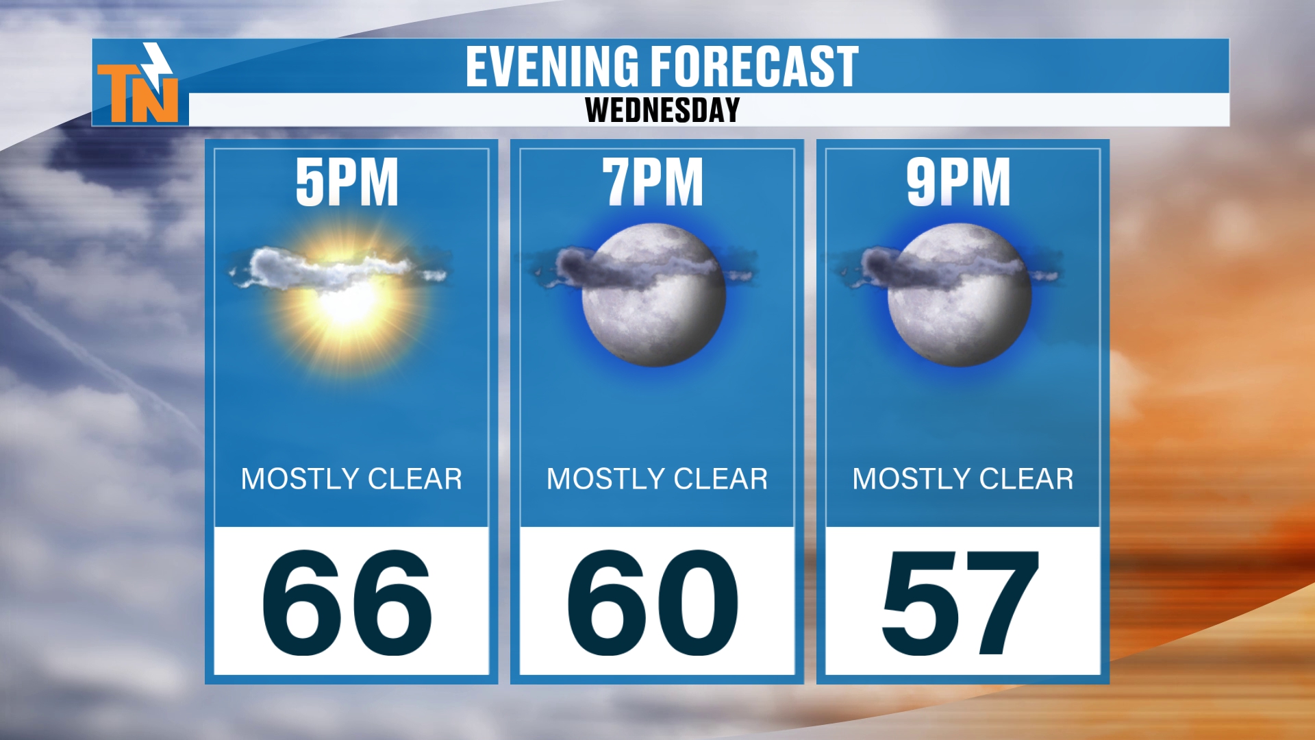
That’s going to make for a nice evening around town as we dip down to about 60 degrees by 7:00 tonight.
But after tonight, that’s when those changes start to settle on in.
The Upper-Level Energy Behind Old Man Winter
We’ve got a big old trough in the upper level pattern and a lot of energy spinning around this upper level low. This is 500 millibar vorticity, mid-level energy and spin in the atmosphere, running about 18,000 feet in elevation.
You can see these little vorticity lobes, which is what those are called. As they come on through, that’s going to provide us with some upslope snow showers across the mountains of East Tennessee.
Dew Points Fall and the Air Dries Out
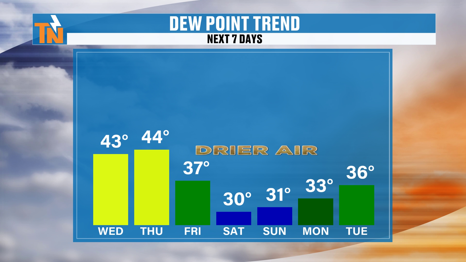
Let’s talk dew points for a second. As this Canadian air settles on in, the air is going to dry out. So static electricity will increase a lot as we get into Saturday and Sunday, with dew points falling into the low 30s.
Remember, our temperatures can and never will fall below the dew point number. So the lower the dew point, the lower our morning lows can go under clear skies. And that’s going to allow for some cold air to settle its way on in.
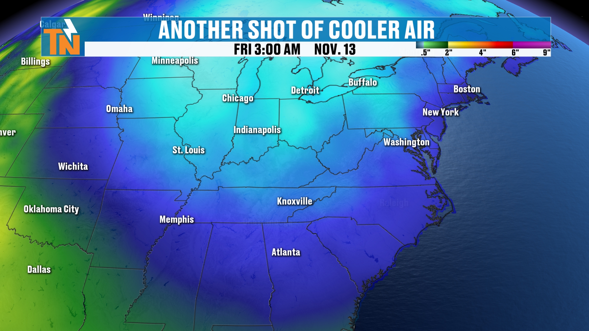
So this system is not only bringing a lot of energy to the atmosphere that’s going to spin off some light rain and some mountain snow showers. It also brings us drier air, which is going to ultimately bring us colder and colder air as well.
Hard Freeze Saturday, Sunday and Monday Mornings
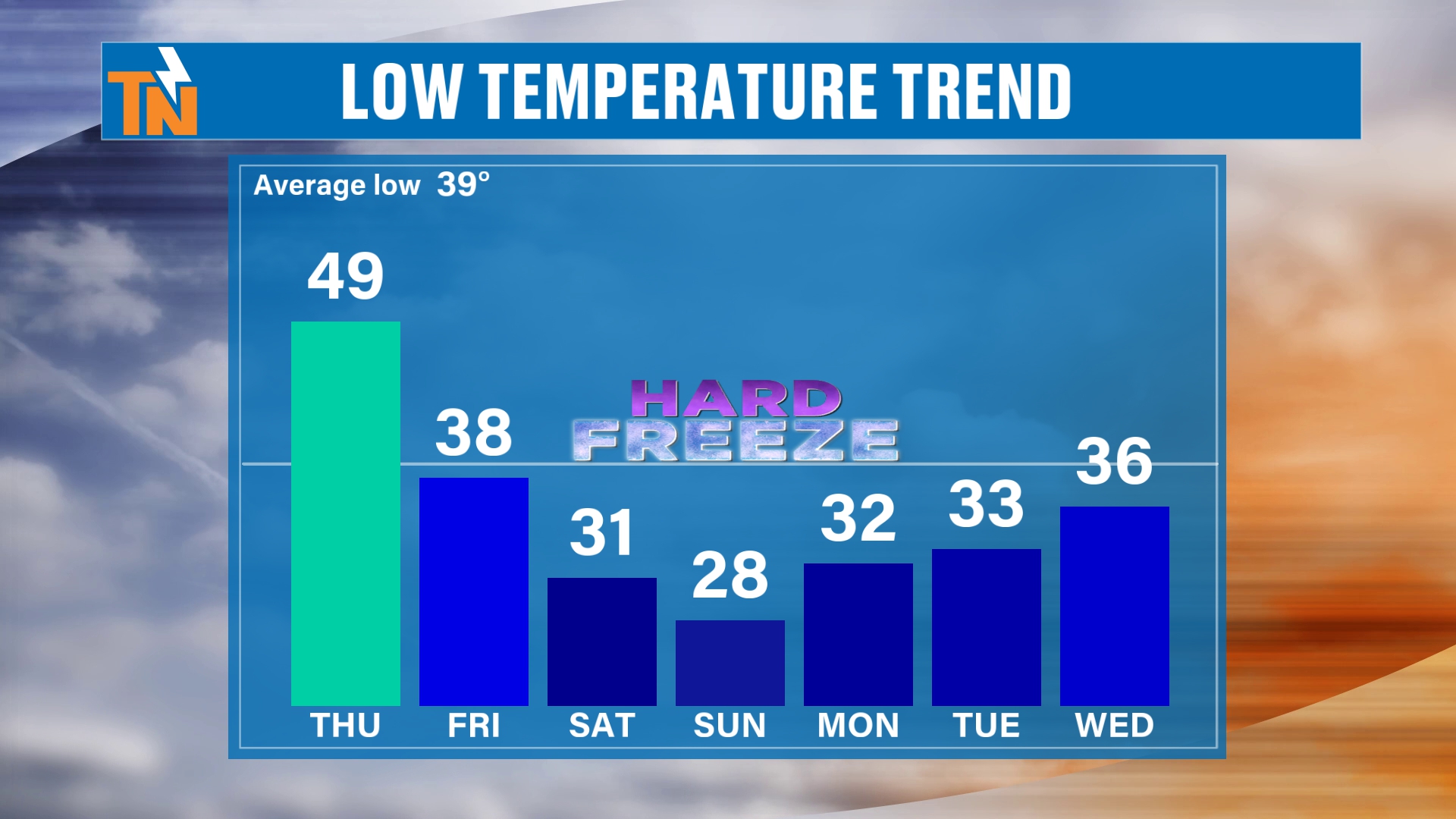
For morning low temperatures, we’re looking at the potential for a hard freeze come Saturday, Sunday and Monday morning.
It’s probably more likely on Sunday morning, as the low temperatures are expected to dip down into the mid to upper 20s.
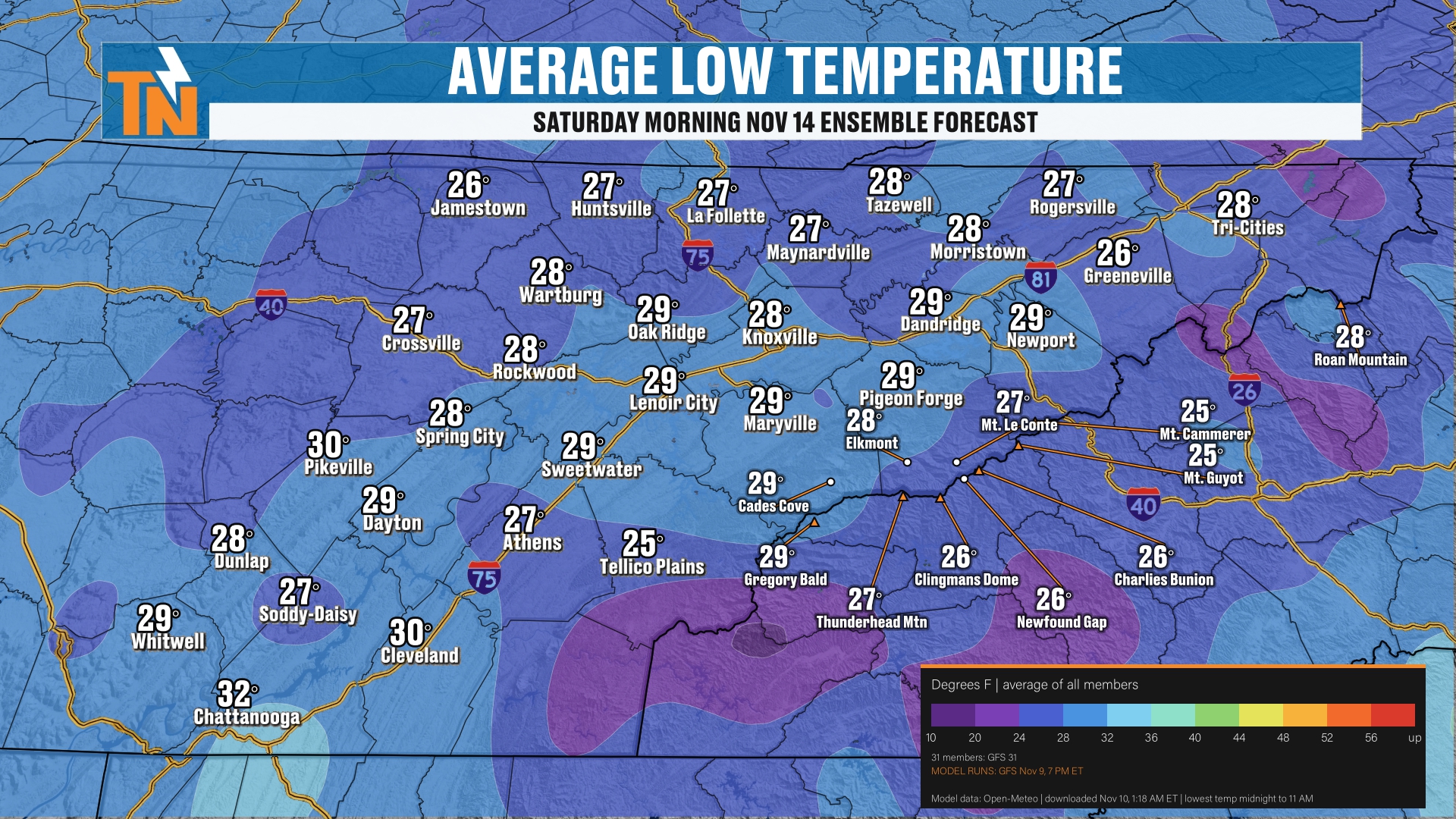
When you look at Saturday morning, our morning lows will be in the upper 20s. Generally speaking, when you’re looking at the ensemble forecast, most of the members are averaging out at about 28 degrees or so.
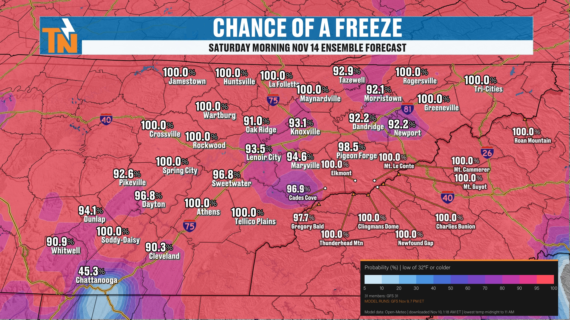
That gives us about a 90 to 93% chance for a freeze.
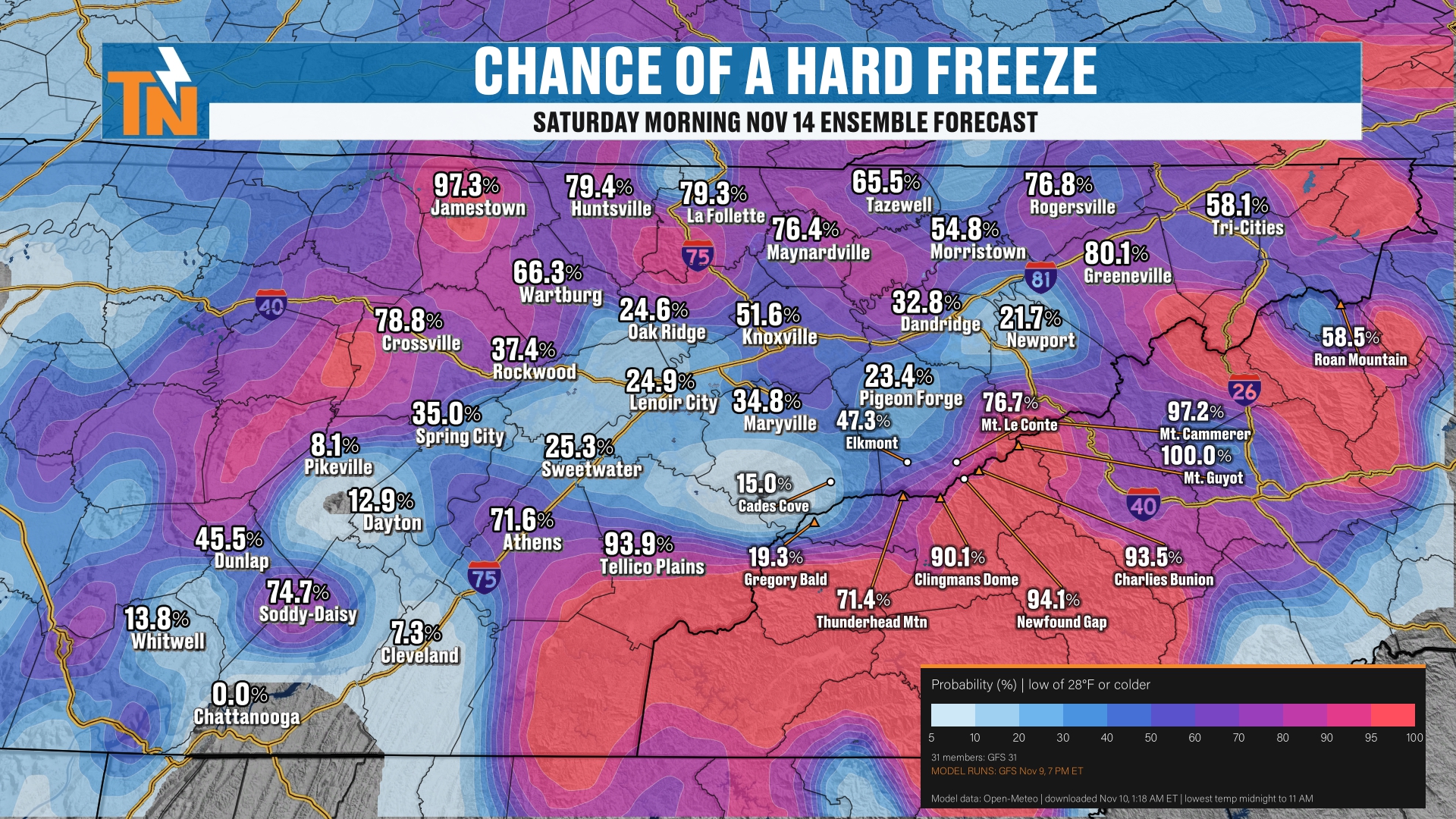
But when we’re talking about a hard freeze, we have a good shot across the plateau, from Wartburg to Jamestown, Crossville to Huntsville and La Follette. Anywhere between there, and the foothills and the mountains, are looking like a hard freeze as well.
That’s at least a 90% chance. And in the lower elevations of the valley, it’s anywhere from about a 30 to 50% chance for a hard freeze.
And again, that’s for Saturday. We’re likely to have a hard freeze on Sunday.
Rain Chances Thursday Night Into Friday
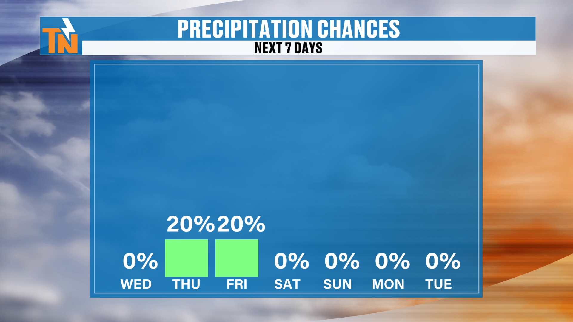
Precipitation chances go about 20%. Most of the rain comes through after sundown tomorrow night, Thursday night, and will be kind of lingering early Friday morning. That should be about the extent of it.
Then we transition from the rain to maybe a few flurries flying around parts of town as well.
The Futurecast Timeline
Let me show you the big picture weather pattern. Here’s our Futurecast model. We’ll pick up our timeline this morning.
Again, severe storms are possible late tonight into early tomorrow morning across parts of Middle Tennessee.
As we get into our Thursday, it’s all rain showers. But Thursday night into Friday morning, it transitions over to snow across the mountains of East Tennessee, stretching along the Appalachian Mountains all the way up into West Virginia.
Then we have some lingering clouds, and maybe a little bit of light rain spitting from time to time as we get into our Friday, Friday night and Saturday morning, with more snow showers.
But after about Saturday morning, I think the snow machine quickly comes to an end.
The Snow Probabilities
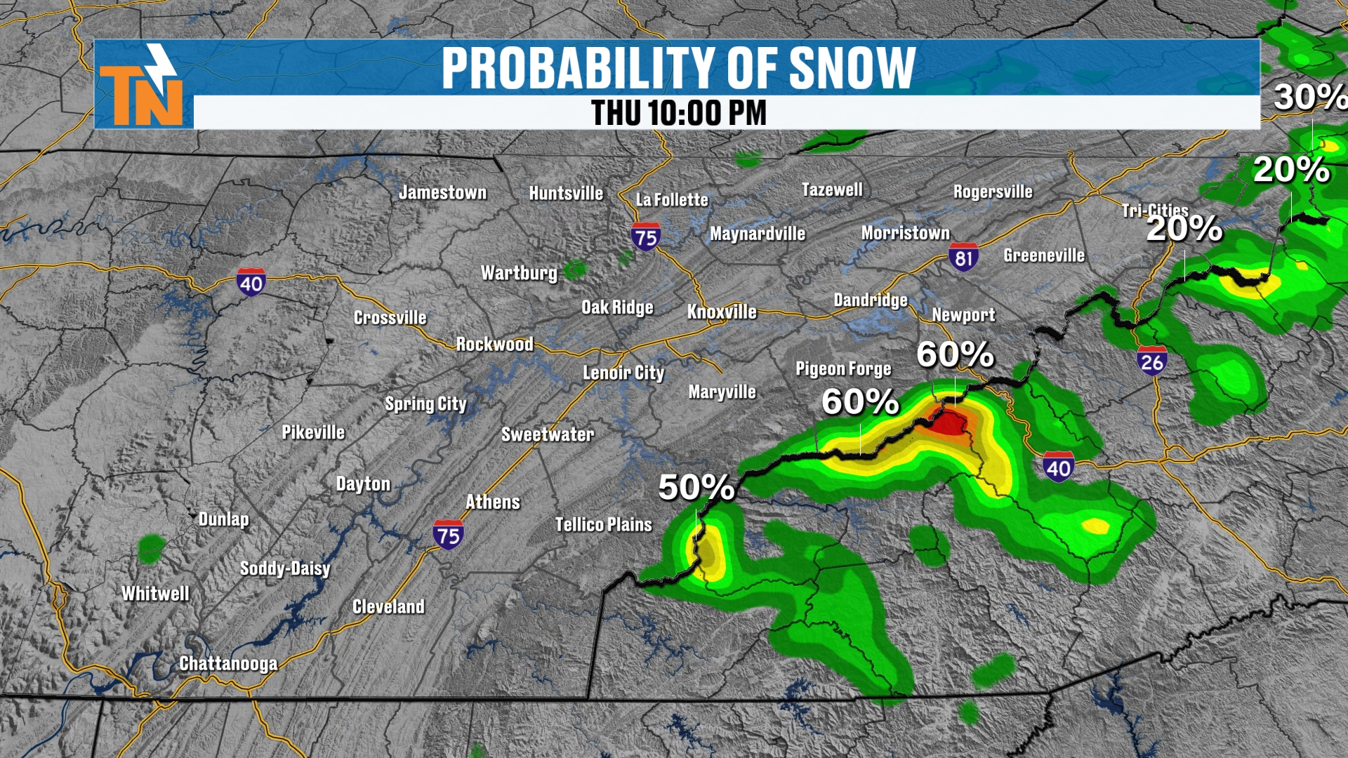
The probabilities of it actually snowing in the mountains are pretty high. All the way through 10:00 Thursday night, we’ll start to see the increased chances for some snow showers across the mountains.
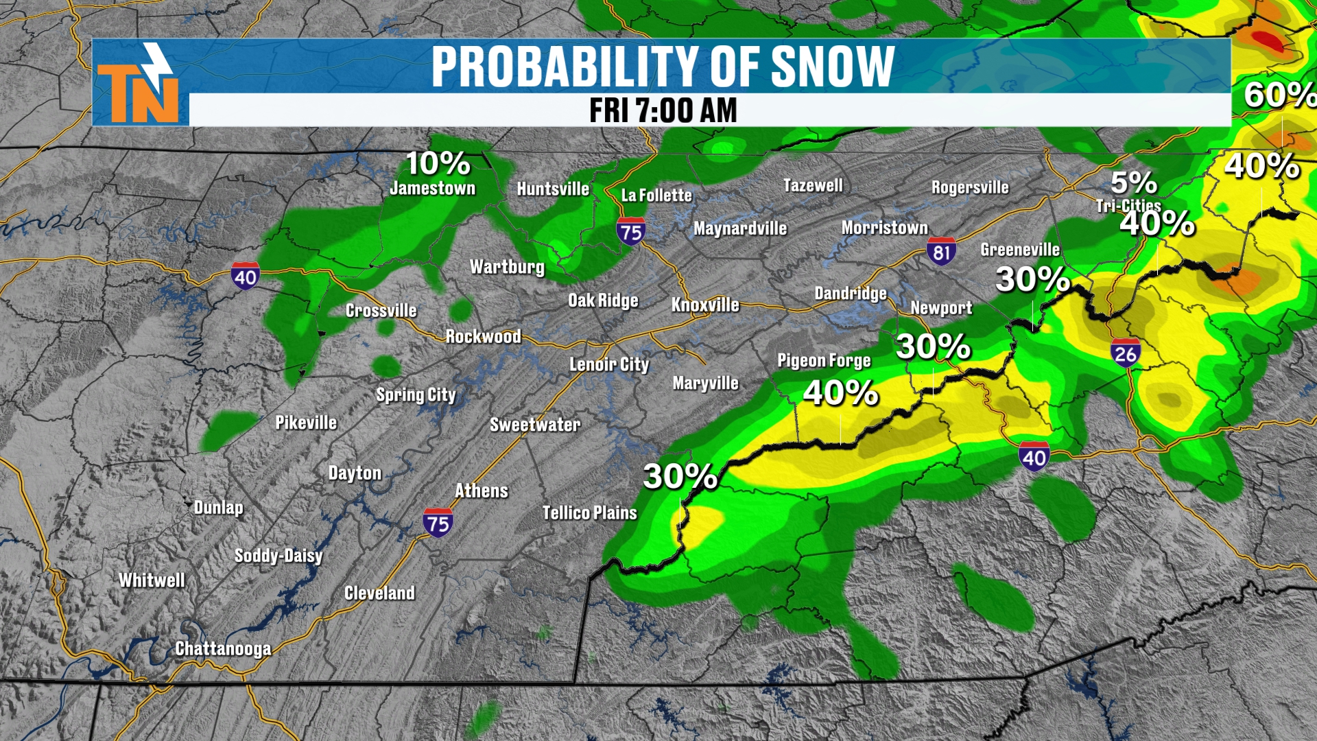
We’re going to keep those snow chances going through 7:00 Friday morning.
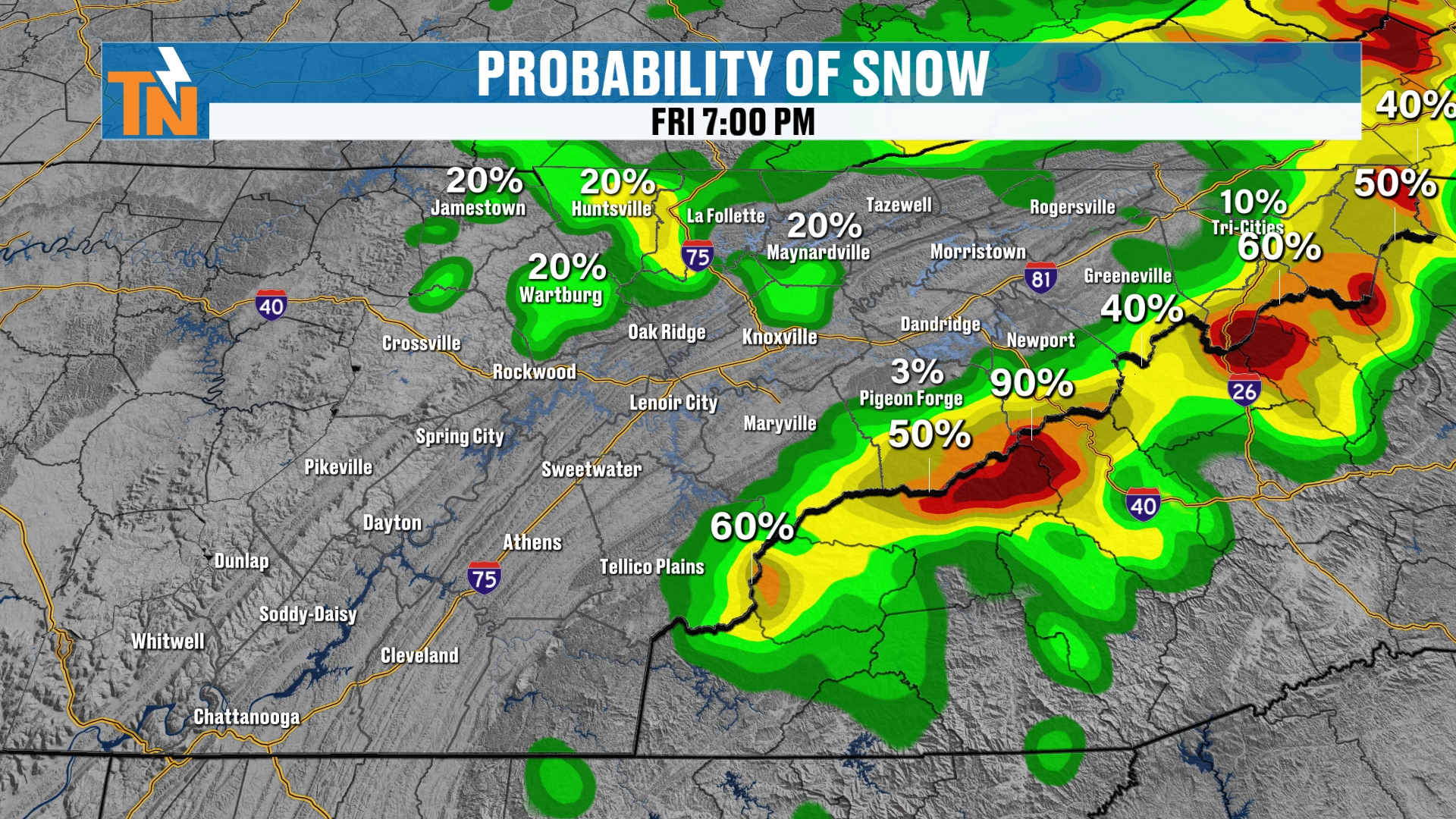
Then through the day on Friday, at noon, we’re sticking with that chance for snow. And Friday night, we may have another higher opportunity for some snow showers developing across the mountains.
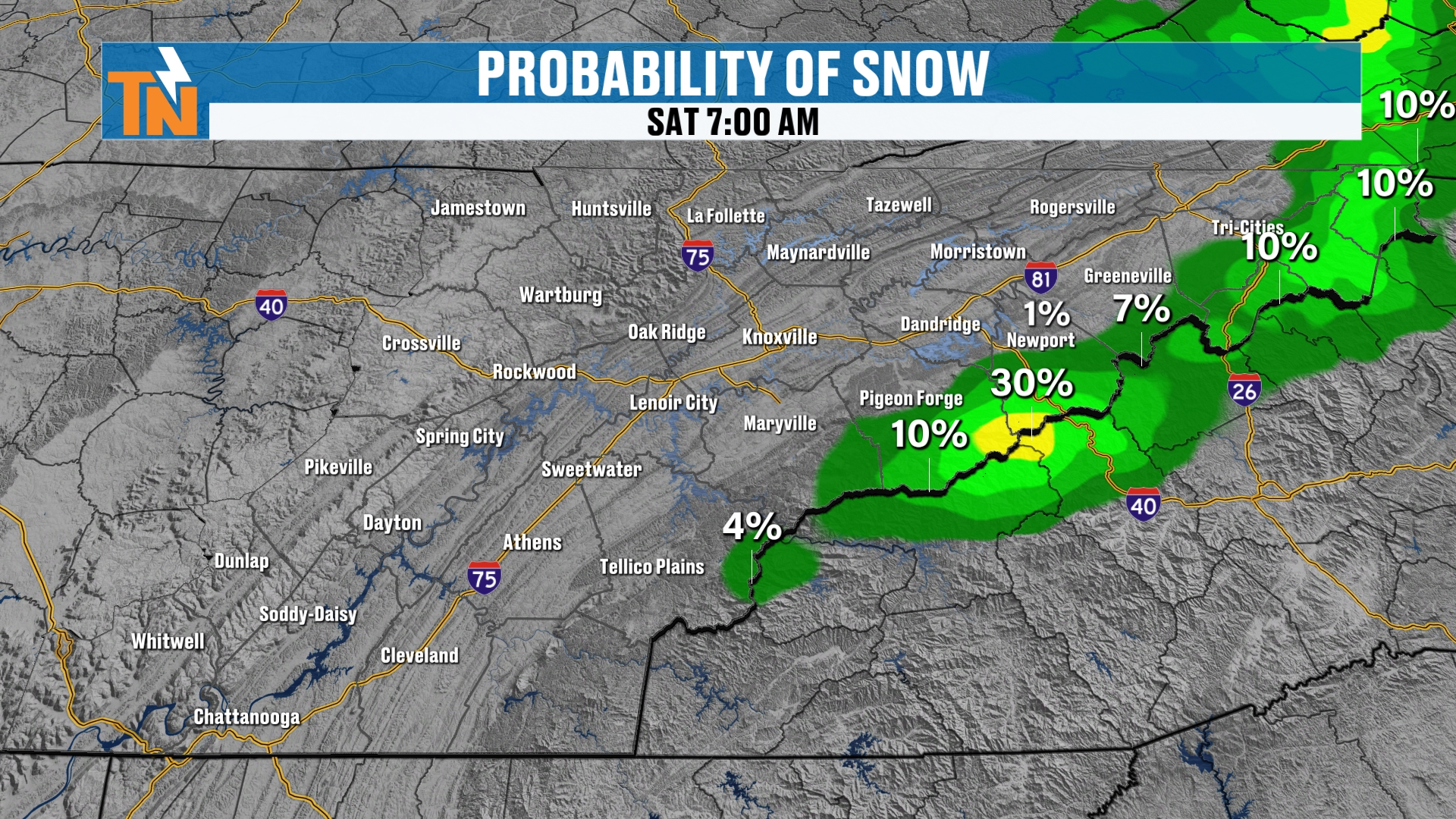
Then we lose that energy and the moisture, and the snow machine really starts to die down as we get into our Saturday morning.
How Much Snow? The Official Forecast
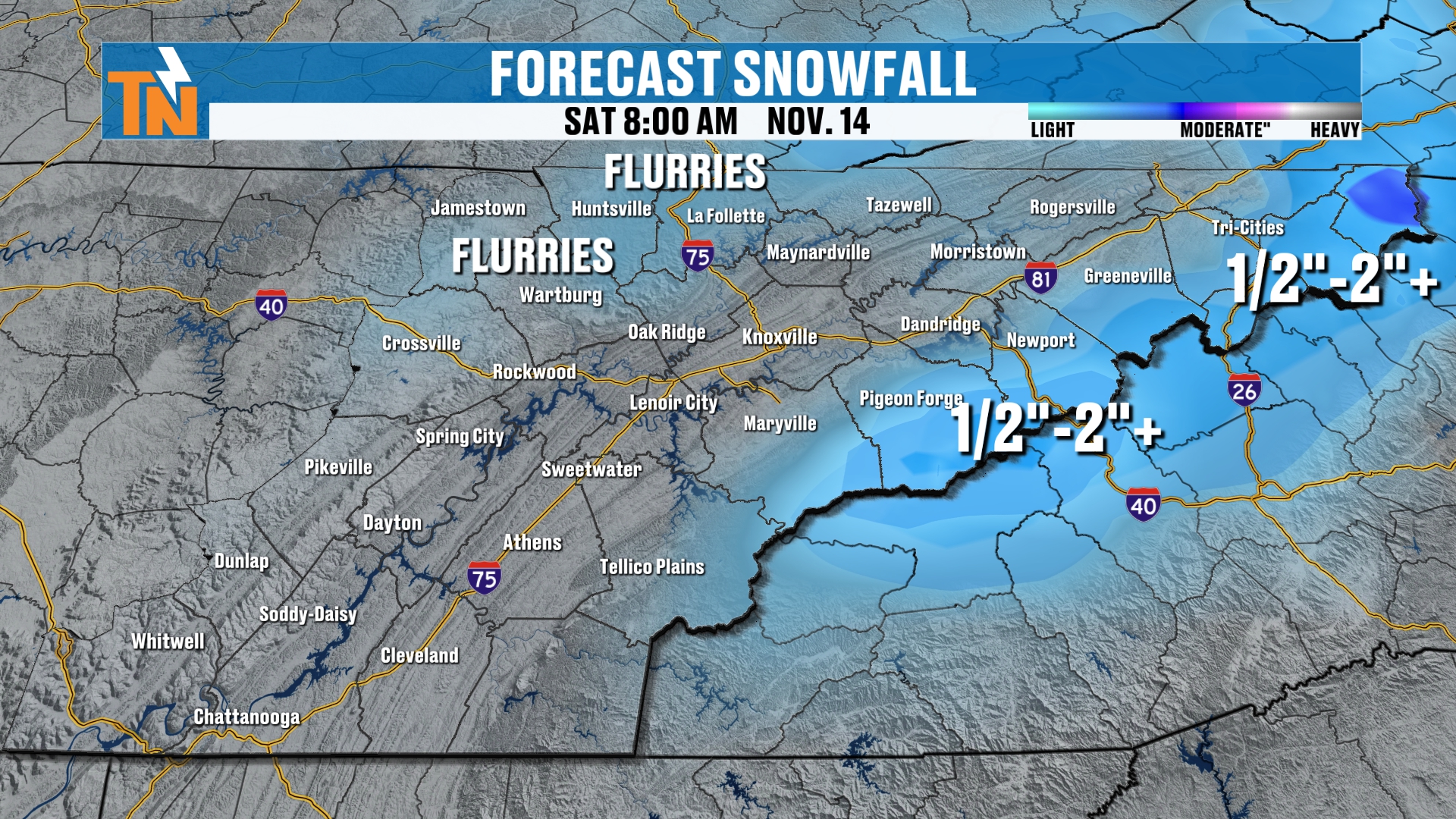
So how much snowfall are we talking about around the area?
The mountains are going to get the highest amounts. Again, it’s going to be isolated higher amounts, but generally speaking, we’re looking at some light snow around the area.
Notice the lighter shades of blue across the northern plateau. I can’t rule out some flurries flying around parts of the Cumberland Plateau, through this entire event.
Up across the mountains, I think half an inch to two-plus inches. Some models indicate that we could see four to five inches across the highest peaks of the Smokies, so I can’t rule that out.
But generally speaking, about a half an inch to two-plus inches is looking likely.
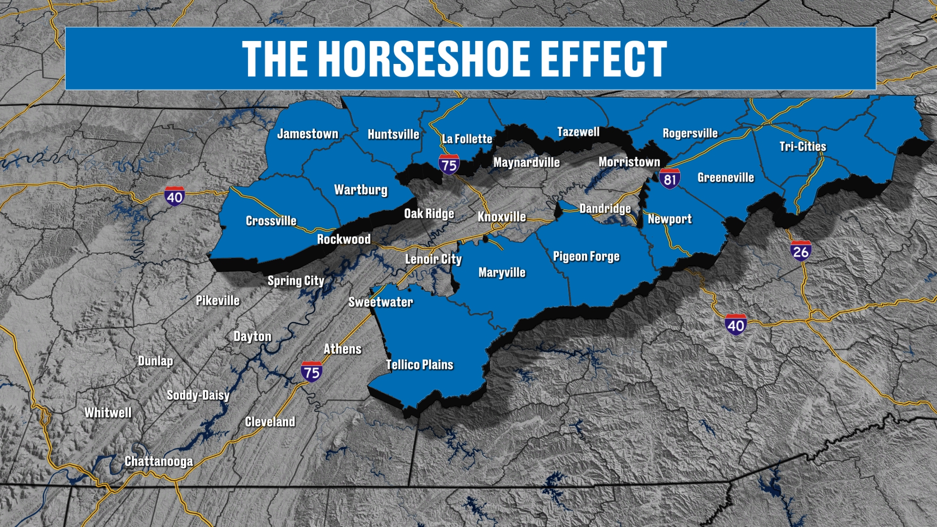
We highlight the classic horseshoe in East Tennessee because that’s where we have the best opportunity for snowfall in the winter season here in East Tennessee.
Rain Totals and the Longer Range
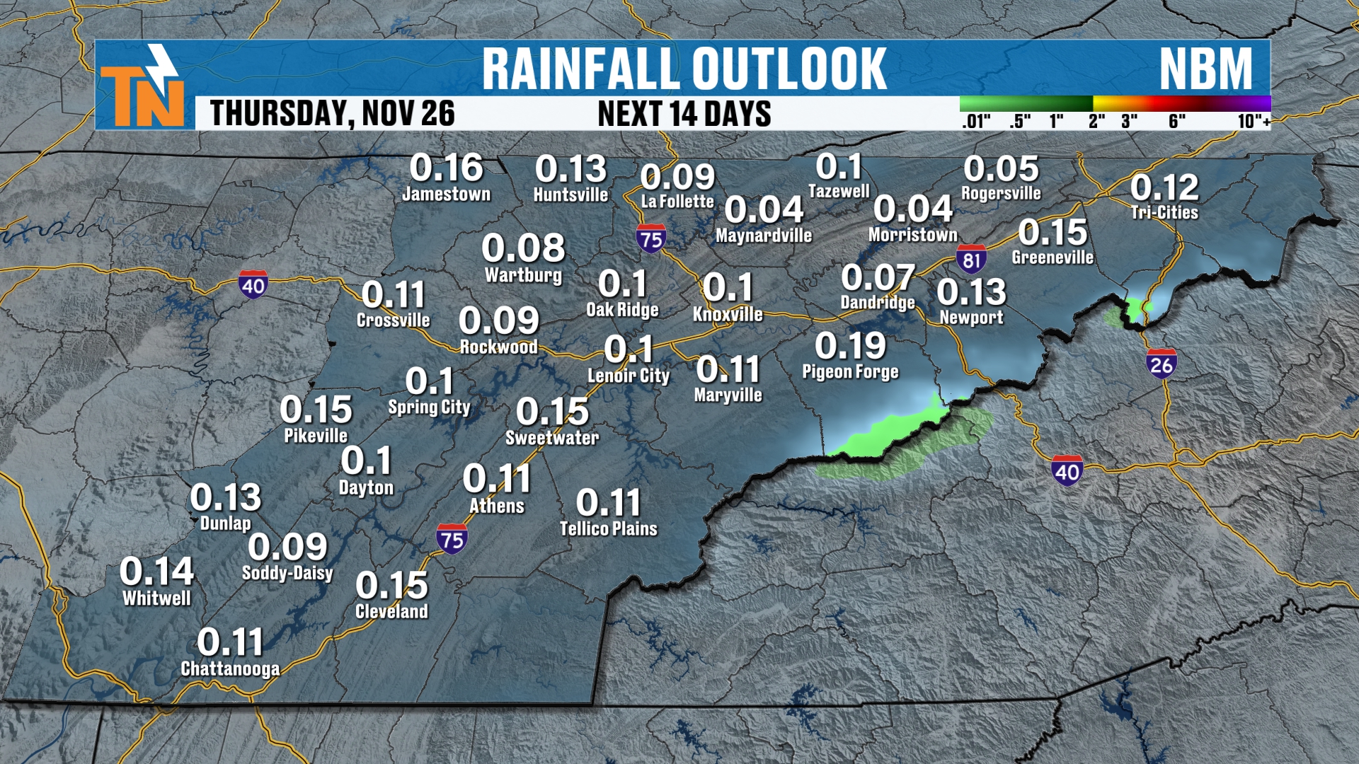
Either way you look at it, we are looking at some opportunity for rain. It’s not going to add up to a whole lot.
When you look at your 14 day outlook from the National Weather Service blend models, it’s not picking up on a ton of moisture around the area.
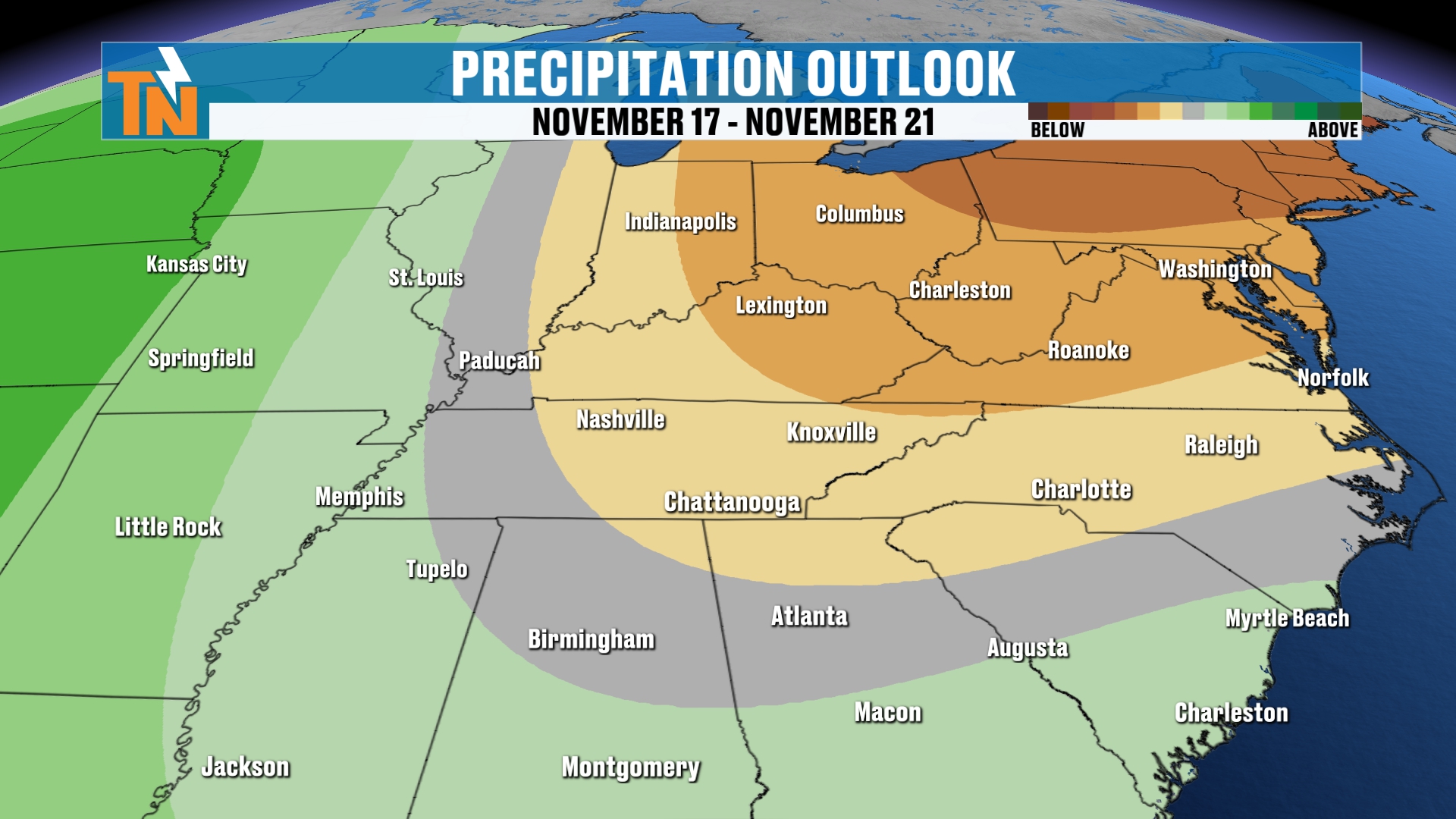
So it looks like we are going to continue to stay dry along the 6 to 10 day outlook.
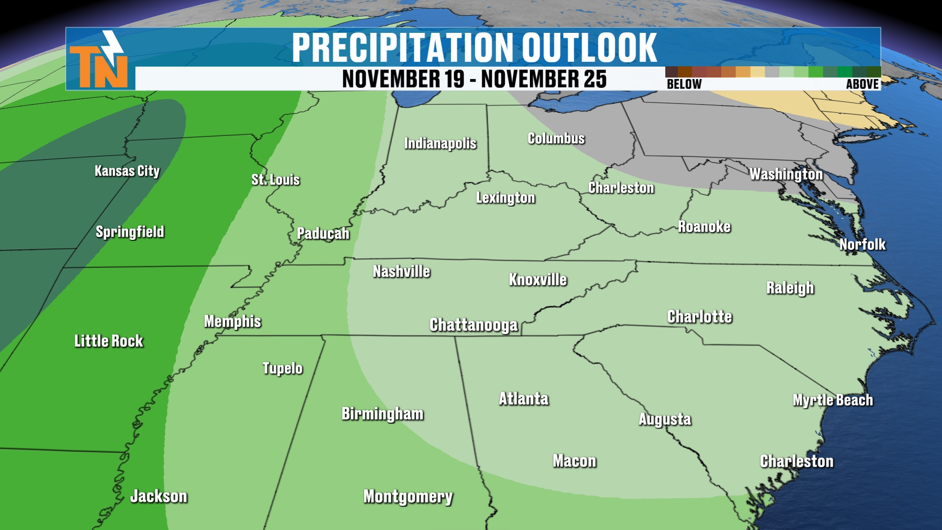
But in your 8 to 14 day outlook, we may start to see some elevated rain chances or opportunities. So of course, we’ll see how that all plays out.
Your 7-Day Forecast
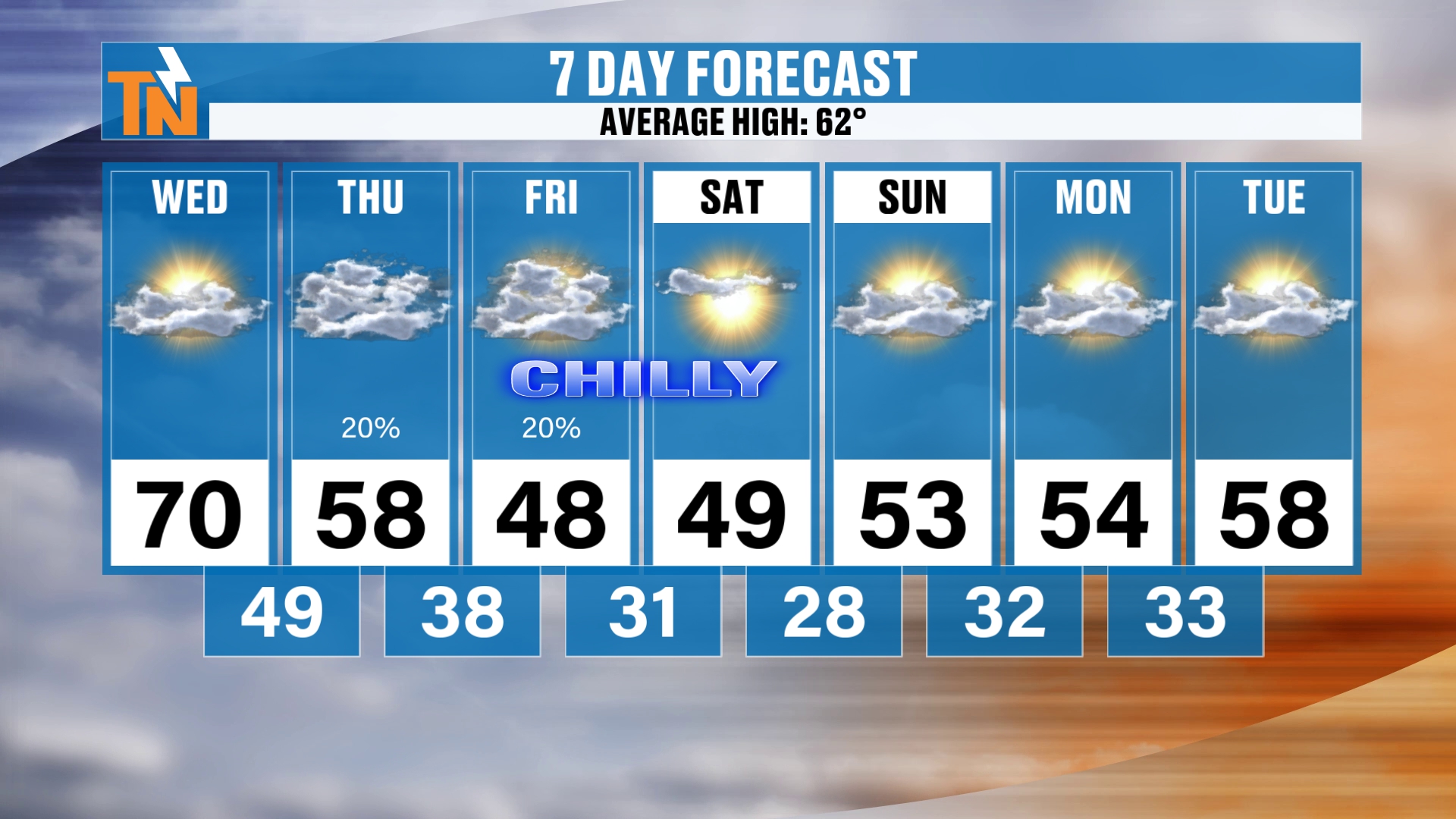
First things first, we’ve got to get through this little cold blast of old man winter. We go from 70 today down to 48 on Friday and 49 on Saturday.
So it’s going to be chilly for high school football games on Friday night. It’s even going to be chilly tomorrow night for some of those Thursday night high school football games.
Those morning lows are looking like a lot of frost and a hard freeze heading our way Saturday, Sunday and Monday morning. We stay on the chilly side on Tuesday morning, but at least those temperatures rebound back into the upper 50s on Tuesday.
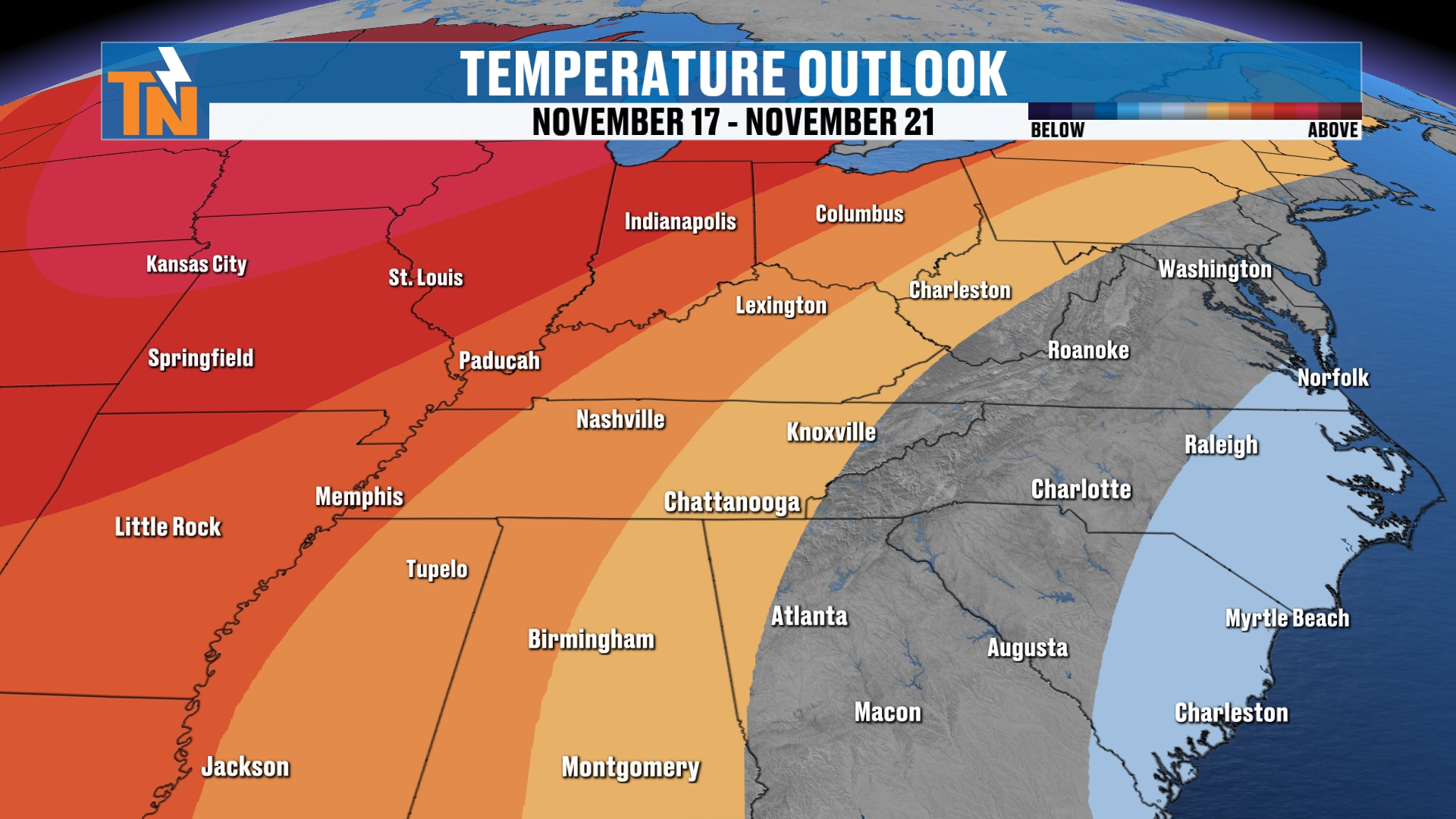
Above and beyond the 7-day forecast, the Climate Prediction Center is still predicting above average temperatures heading our way.
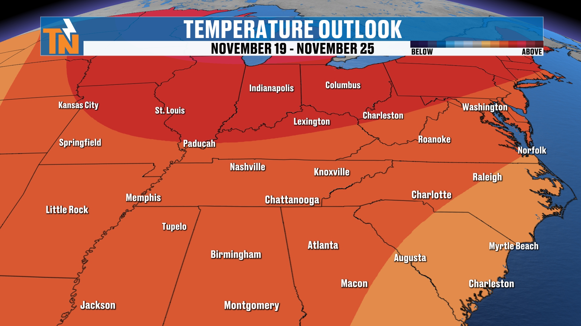
So we are looking at warmer than average weather, generally speaking, across the 7 to 14 day stretch. That’s with that pocket of old man winter chill heading our way Friday, Saturday and Sunday.
Bottom Line
WEDNESDAY (TODAY): Fog and a little frost early, then plenty of sunshine. Low 60s at lunchtime, a high near 70, and about 60 by 7 PM. A little afternoon breeze.
THURSDAY: Rain showers move in, with a 20% chance, and most of the rain arriving after sundown. A high near 58. Chilly for Thursday night high school football.
FRIDAY: Lingering light rain early, then transitioning to mountain snow showers. Chilly, with a high near 48. Another higher snow chance Friday night in the mountains.
SATURDAY: Even chillier, with a high near 49. A hard freeze is possible, with lows in the upper 20s. The snow machine comes to an end by morning.
SUNDAY: Likely a hard freeze, with lows in the mid to upper 20s.
MONDAY: Another hard freeze possible.
TUESDAY: Still a chilly morning, then rebounding into the upper 50s.
It’s going to be darn right chilly. Hard freezes are looking likely, and we’ll have some light snow showers across the mountains.
I think it’s going to be a nice, beautiful view with some of the cameras that I have around town. You’ll be able to check out the little snowfall and see that snow line, where the snow actually stops falling in the Smokies. It’s going to be a gorgeous view.
If you’re a photographer, get out and take some photos of the beautiful snowfall in the mountains. I know you like to do that. You can upload those for free on the East Tennessee Weather app.
For more daily updates, check out our Daily Forecast page.
If you don’t have the app, go to your app store and search East Tennessee Weather. Download it for your cell phone and your tablets. I’m also on Roku TV and Amazon Fire, so you can download the app for your smart TVs and have the 24-hour channel playing in the background while you get ready for work and school.
And at 7:30 in the morning, Monday through Friday, I broadcast live. It’s a nice little community that we’ve developed. I call it Wake Up With Witcher. You should tune in sometime.
Don’t forget to LIKE, SHARE and SUBSCRIBE to the YouTube channel.
I’m Meteorologist Mike Witcher. Have a great Wednesday!
eastTNweather — Weather When You Want It.