
Published: Sunday, November 1, 2026 | By Meteorologist Mike Witcher | eastTNweather
Good morning, East Tennessee, and welcome to the month of November!
Rain is falling across parts of the region this Sunday morning. It’s light, it’s more of a nuisance than anything else, and it’s going to weaken as the day goes on.
But the bigger story is what’s coming in the middle of this upcoming week. A much stronger storm system is headed our way, and it could finally bring the 1 to 2 inches of rain we desperately need.
Let’s get to work.
Welcome to November: A Month of Transition
Here’s the big picture for the month ahead.
Rain chances gradually increase through November, December and January. Well, precipitation anyways. Temperatures will continue to come on down for the rest of the month.
That means we’re going to keep losing a little bit of our average high temperature as the weeks go by. November is a transition month.
And we know November can also be our secondary severe weather season.
We are looking at another storm system to head our way in the middle part of this upcoming week. I don’t necessarily think we’re looking at severe weather here locally. But there will be some severe weather that ramps up back off to our west.
I’ll walk you through all of it, so keep reading.
Yesterday's Almanac: A Mild, Dry Halloween
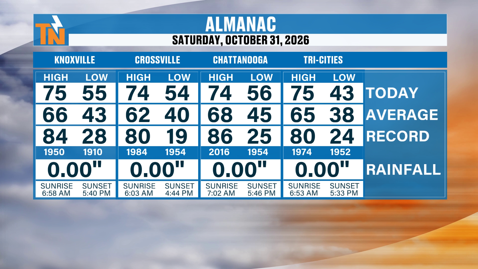
Yesterday we topped out at 75° in Knoxville.
What an amazing Halloween it turned out to be!
Yesterday evening was great. We were dry, cloudy and definitely very comfortable for trick-or-treating.
Here’s how the almanac shook out. Knoxville hit 75° with a low of 55°. The average high is 66°.
Crossville reached 74° (average 62°), Chattanooga reached 74° (average 68°), and the Tri-Cities made it to 75° (average 65°).
Every one of those cities finished with 0.00″ of rainfall. All of us made it into the mid 70s.
Rain Is Falling This Morning, But It's Light
We do have mostly cloudy skies and some light rain showers hanging out with us already this morning.
These light rain showers are going to be more of a nuisance than anything else. Just a little bit of light rain, and that’s about the extent of it.
When you look at our radar recap over the last 3 hours as of this recording, there are some pockets of moderate showers. But the atmosphere did saturate in some spots, while it’s drier in others.
That means less rain as it moves its way to the north and northeast.
So I think you’re going to be on the drier side from Tazewell to Rogersville and the Tri-Cities. A little bit of light rain or a couple of sprinkles. That should be about it.
There’s a little more activity back off to our west. Over in Middle Tennessee you’ve got a big old batch of heavier rain, as we’ve been talking about over the last couple of days.
That’s where the bullseye for some of the heaviest rain was going to be.
As it traverses its way into East Tennessee, this will continue to weaken.
However, with that said, because we’ve already had some rain showers this morning, we’ve saturated the column of the atmosphere. So anything that comes in throughout the rest of the day has a better potential of producing some light rain at the surface.
The Bigger Picture: An Upper-Level Wave to Our West
Here’s what’s going on on the larger scale.
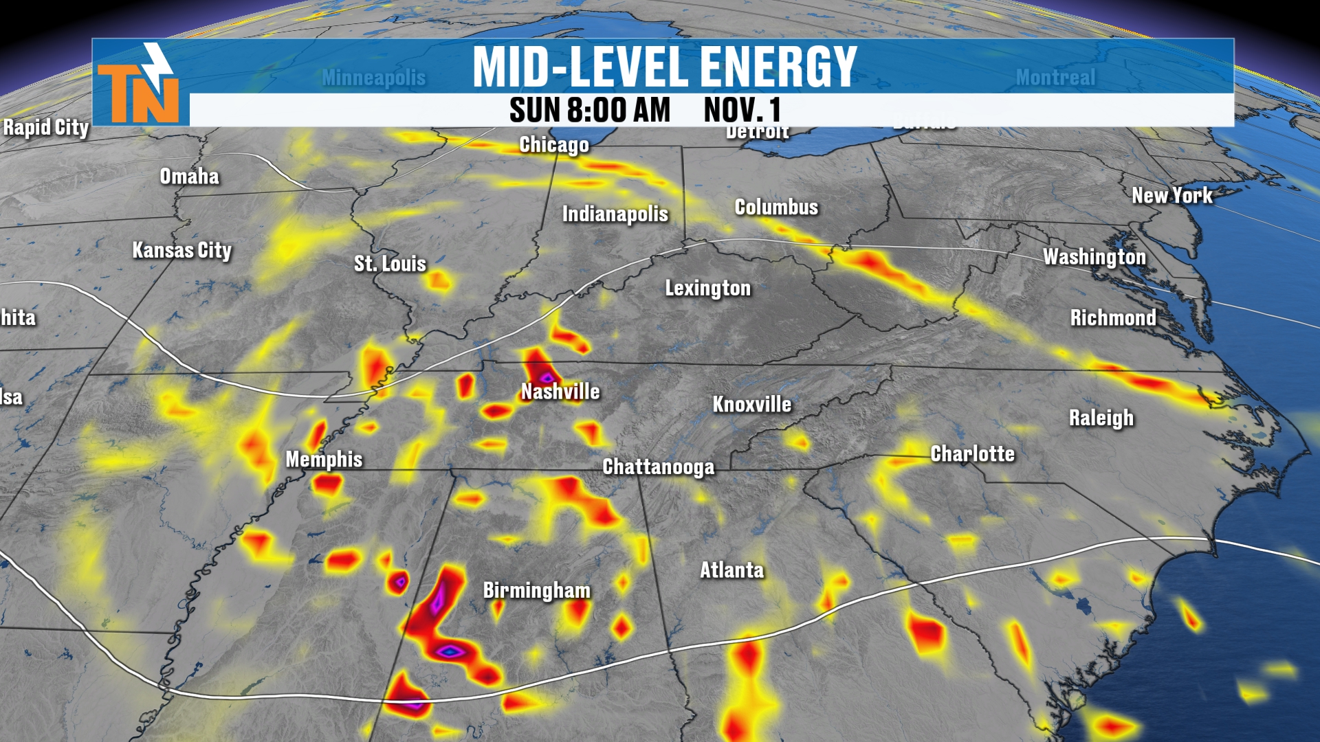
You can see the rain all the way from Mississippi, west of Middle Tennessee, pushing into Kentucky, Alabama and Georgia.
All of this is going to continue to swing its way through, thanks to this upper-level wave that’s still anchored back to our west. It continues to track its way to the north and northeast.
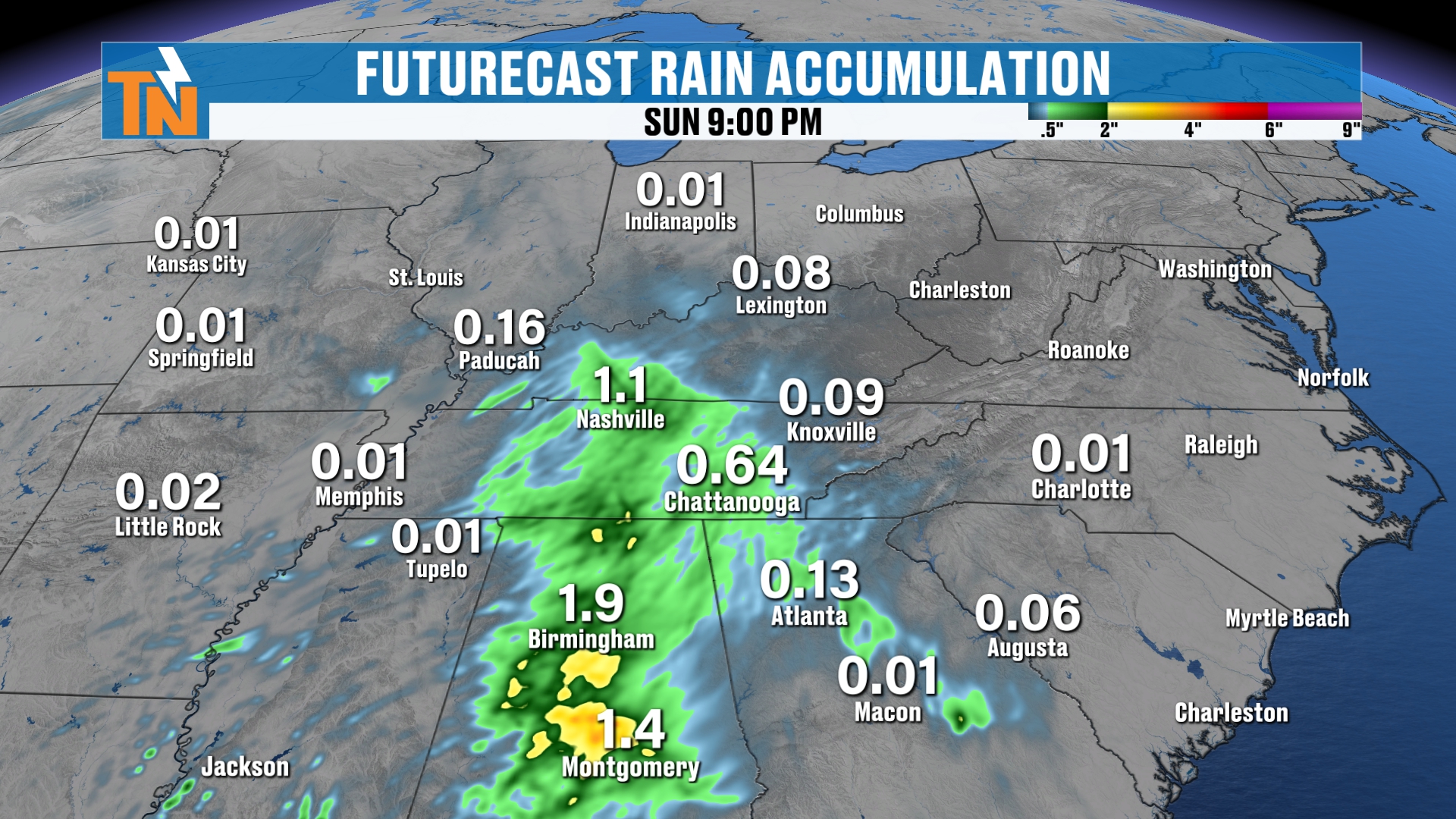
Here’s a quick preview of what the rest of your weekend looks like with the futurecast model.
As we pick up our timeline this morning and run through the day, you can see how the moisture just kind of weakens and fades away.
We’ll still see some heavier showers over in Alabama, parts of Middle Tennessee, and southwest into northern Georgia. But as this batch of energy comes on through, it should continue to weaken.
That’s going to leave us with cloudier skies and some light rain.
The heaviest rain, again, is still expected across Middle Tennessee and also parts of Alabama.
Rain Is Falling Locally: Timeline for the Day
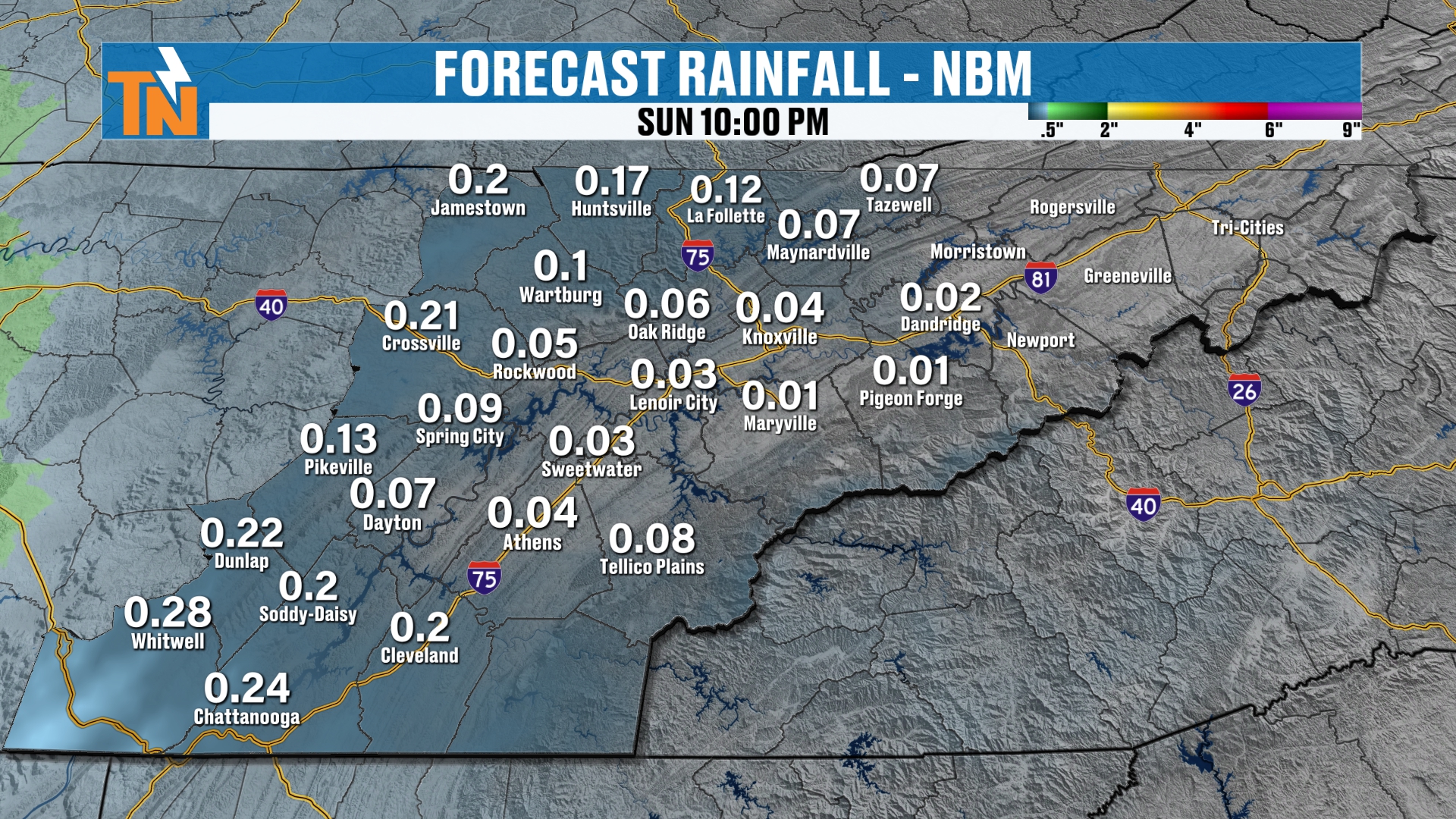
Let’s pick up our timeline locally and give you a better idea of what’s going on here at home.
As we progress through the day, you can see how these showers are with us this morning, and we’ll continue to see them weaken a little bit as they move to the north and northeast.
So I don’t anticipate a whole lot of rain by the end of the day.
Who gets the heaviest rainfall? I think the central and southern Cumberland Plateau.
Do we actually potentially see upwards of 3/4 of an inch of rain? Maybe. It depends on how that all plays out over in West and Middle Tennessee right now. It depends on how much rainfall gets across the Cumberland Plateau.
Now, this has definitely ramped up over the last 24 hours from what we were talking about even yesterday morning.
But it is still light rain. Either way you look at it, it is beneficial rain.
And the fact of the matter is, we finally broke that streak of dry weather. We were pushing anywhere from 15 to 20 days without a single drop of rain around town. Some areas a little bit more than others.
Sunday Morning Temperatures: Mild Thanks to the Clouds
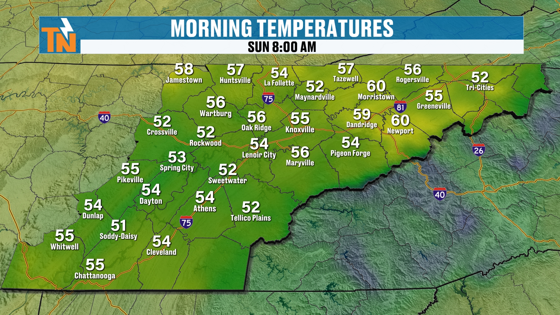
Temperatures this morning, thanks to the clouds, are nice and mild. We’re in the 50s.
It feels pretty good outside. A light jacket or a rain jacket is what you’ll need.
Temperatures are a little bit warmer than they were yesterday morning. And yesterday was a little on the warmer side thanks to the cloud coverage that moved in the previous night.
Clouds at night act like a blanket, and that’s exactly what we’ve had.
Sunday's Forecast: Cloudy With a Chance of Light Rain
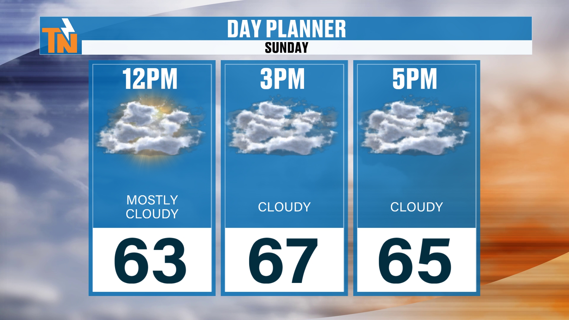
By lunchtime, we’re going to be in the low 60s.
Afternoon temperatures will top out in the mid to upper 60s. That’s a solid average day. That’s right where we should be for this time of year.
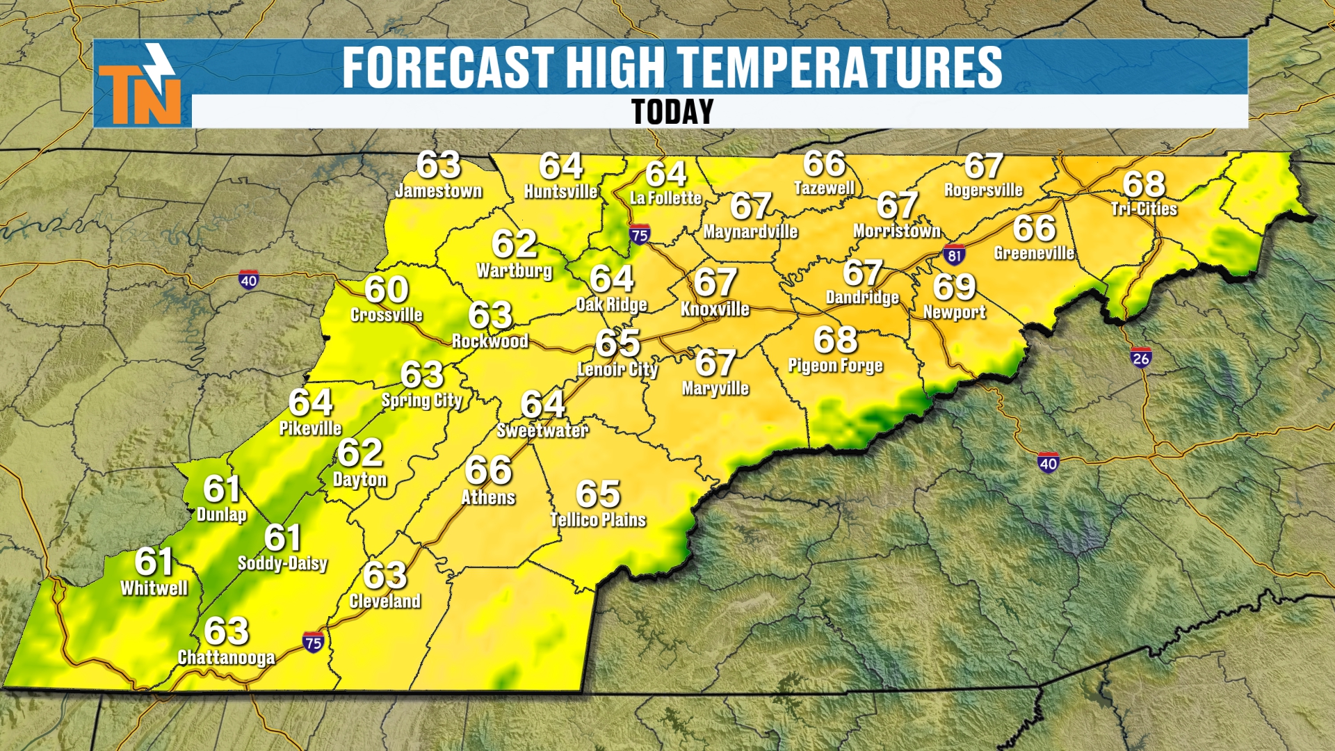
We’re looking at 66, 67, 68, even some low 60s across the western valley and the Cumberland Plateau.
Smokies Winds and Fall Color Photos
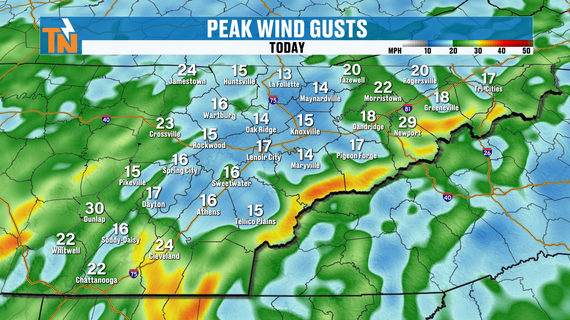
The wind is going to be a little bit stronger across the higher elevations of the mountains.
We have a nice little surge of 850 millibar winds. In other words, winds at 5,000 feet are surging on in.
That’s what’s going to help crank the winds across the highest peaks of the Smokies.
If you happen to have plans to head up to the Smokies to check out some of the fall colors, here’s a little bonus. Thanks to the cloud coverage, you’ll get some nice contrast between the colors in the mountains and the cloudier skies.
Sunny days are nice, but sometimes they’re a little bit tougher to take pictures on.
We’re going to see those winds hang with us throughout the day, especially across the higher terrain, as we get into the evening rush hour.
(Evening rush hour on a Sunday? Come on, Witcher. You know what I mean.)
Evening Forecast and the Time Change
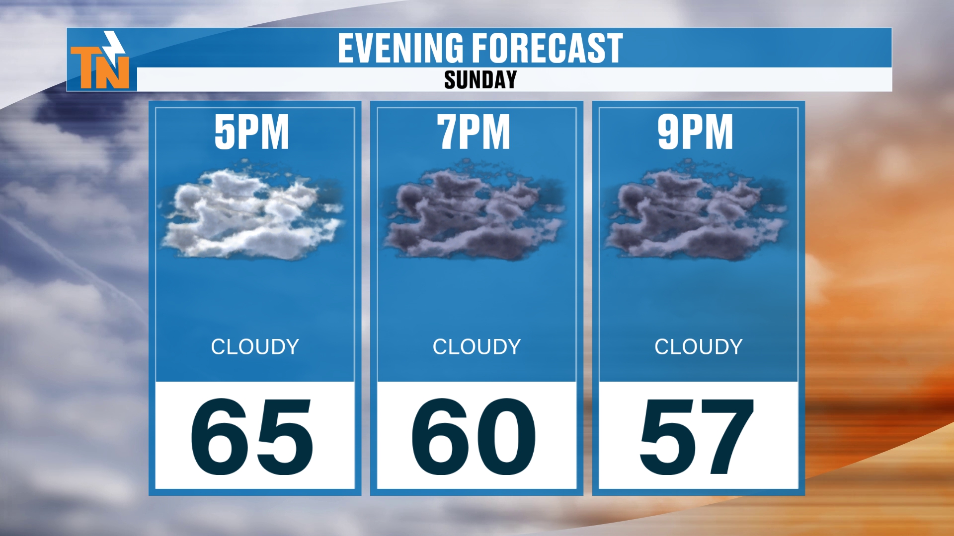
We’re in the mid 60s by 5:00, which is dinner time.
Then there’s 6:00, or is 7:00 going to be bedtime?
Thanks to the time change, the sun now sets here in the 5:00 hour. We’re all going to be like, “Wait a second here, what’s going on?”
We’re going to be in our PJs by 6:30 tonight. Not necessarily a problem, right? Depending on your age, and when you’re watching, and how late you typically stay up.
Rain Chances: Bumped Up to 40% Today
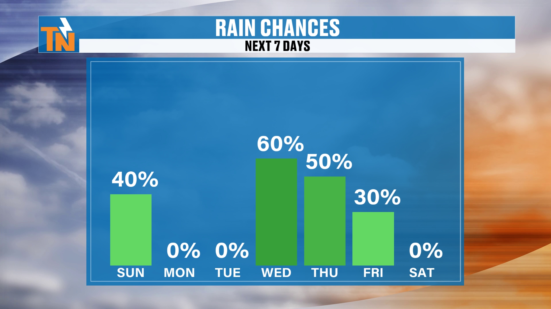
I bumped Sunday up to a 40% chance of rain. I had 20% yesterday.
Yesterday it looked like things were tapering down. But because we have the rain with us this morning, I do think a good solid 40% coverage of rainfall is the general rule.
Then Monday and Tuesday are dry.
And then Wednesday, Thursday and Friday, heavier rain is on the way.
Severe Weather: Where Are the Storms Going?
That heavier rain is associated with this deep trough that’s still expected to come on through the area.
When you look at it, it’s going to produce the potential for some severe weather. It’s a big old swirl in the atmosphere coming through.
That’s going to crank up a southerly wind. High pressure builds in out ahead of it, and that’s going to warm our temperatures up.
Then the system kind of splits a little bit, but it keeps an elevated wave of energy coming on through from Wednesday and Thursday into Friday.
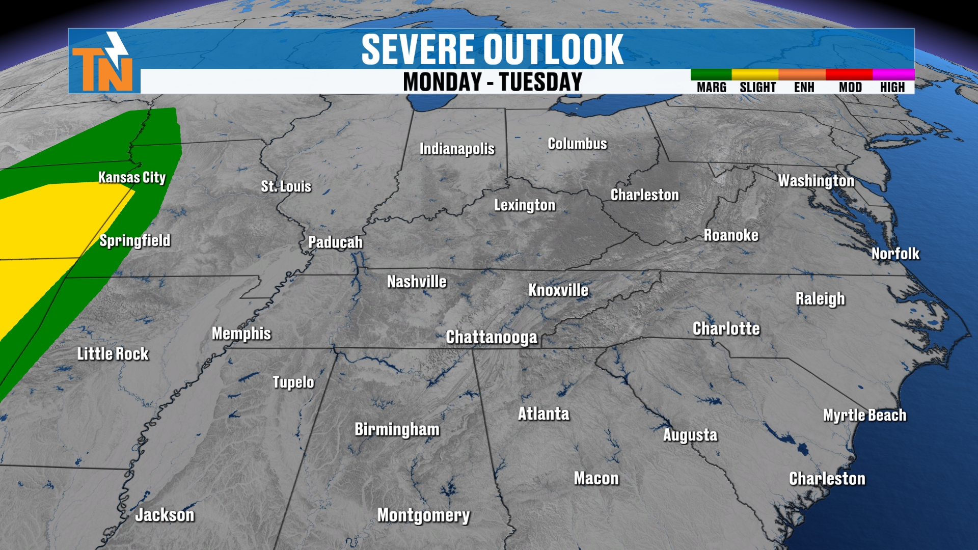
So, Monday into Tuesday, that risk for severe weather is going to be back off to our west.
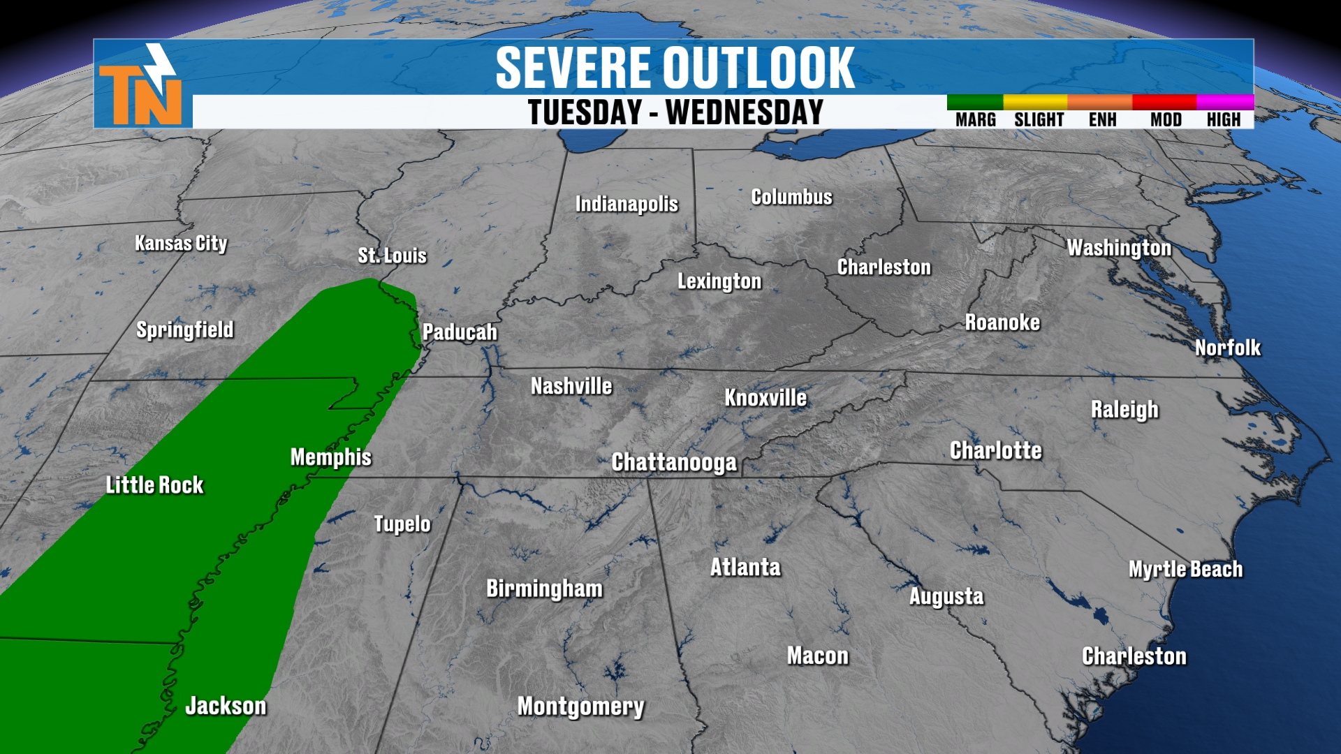
Tuesday into Wednesday, it starts to work its way toward the Mississippi River Valley.
And there’s nothing going on for us Wednesday, Thursday or Friday as of right now.
But that is definitely subject to change.
We’ll see what the Storm Prediction Center does with their outlooks over the next few days. I’ll keep you posted.
Next Week's Storm: How Much Rain?
Let’s talk about rainfall with that next system, because we’re looking at a decent amount of rain.
I still think, generally speaking, most models are showing about an inch to upwards of 1 to 2 inches of rainfall.
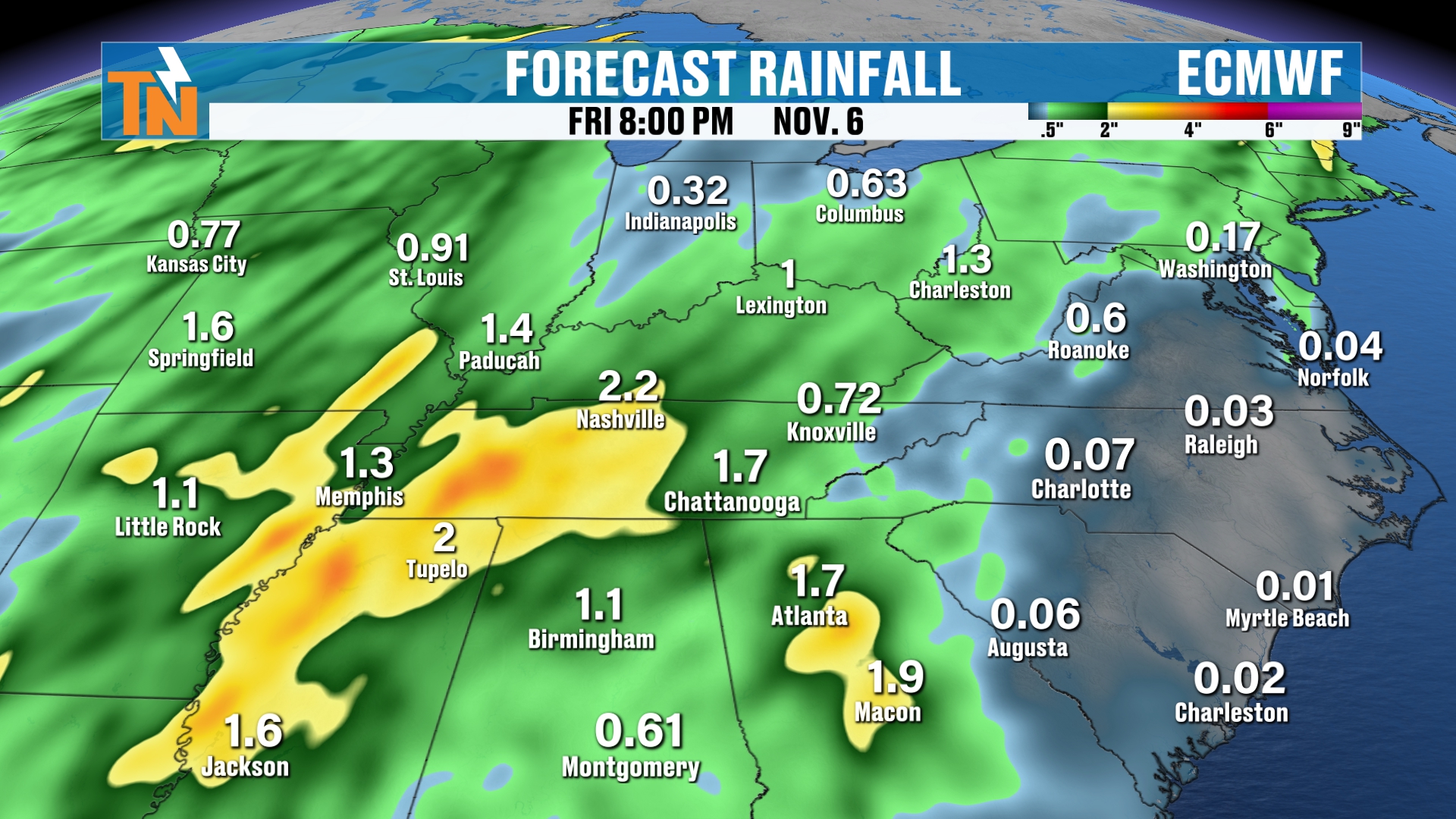
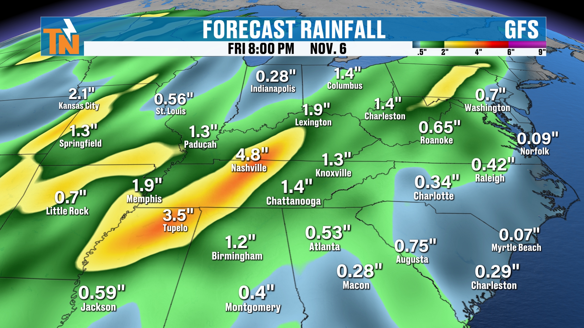
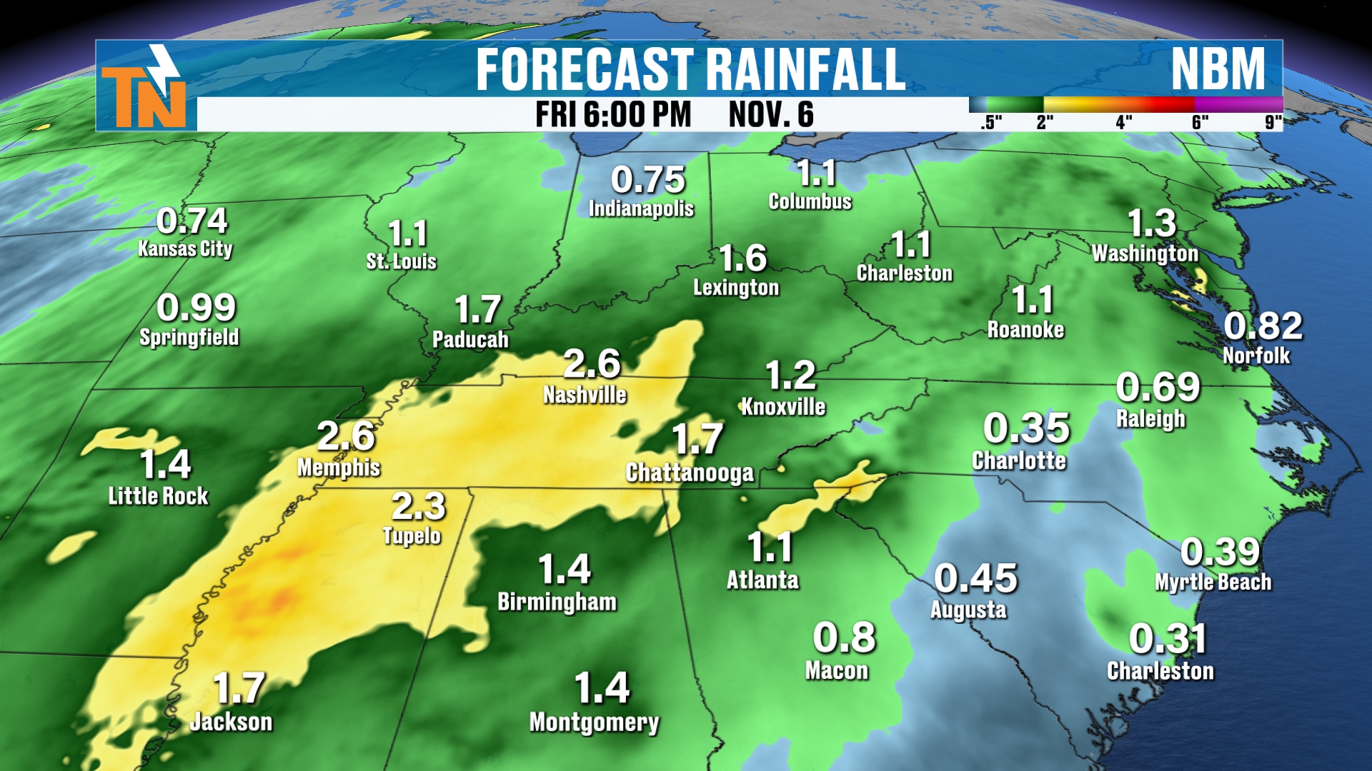
When you look at the National Weather Service blend of models, it’s again one to nearly 2 inches of rain.
The heaviest rain is going to be back to our west.
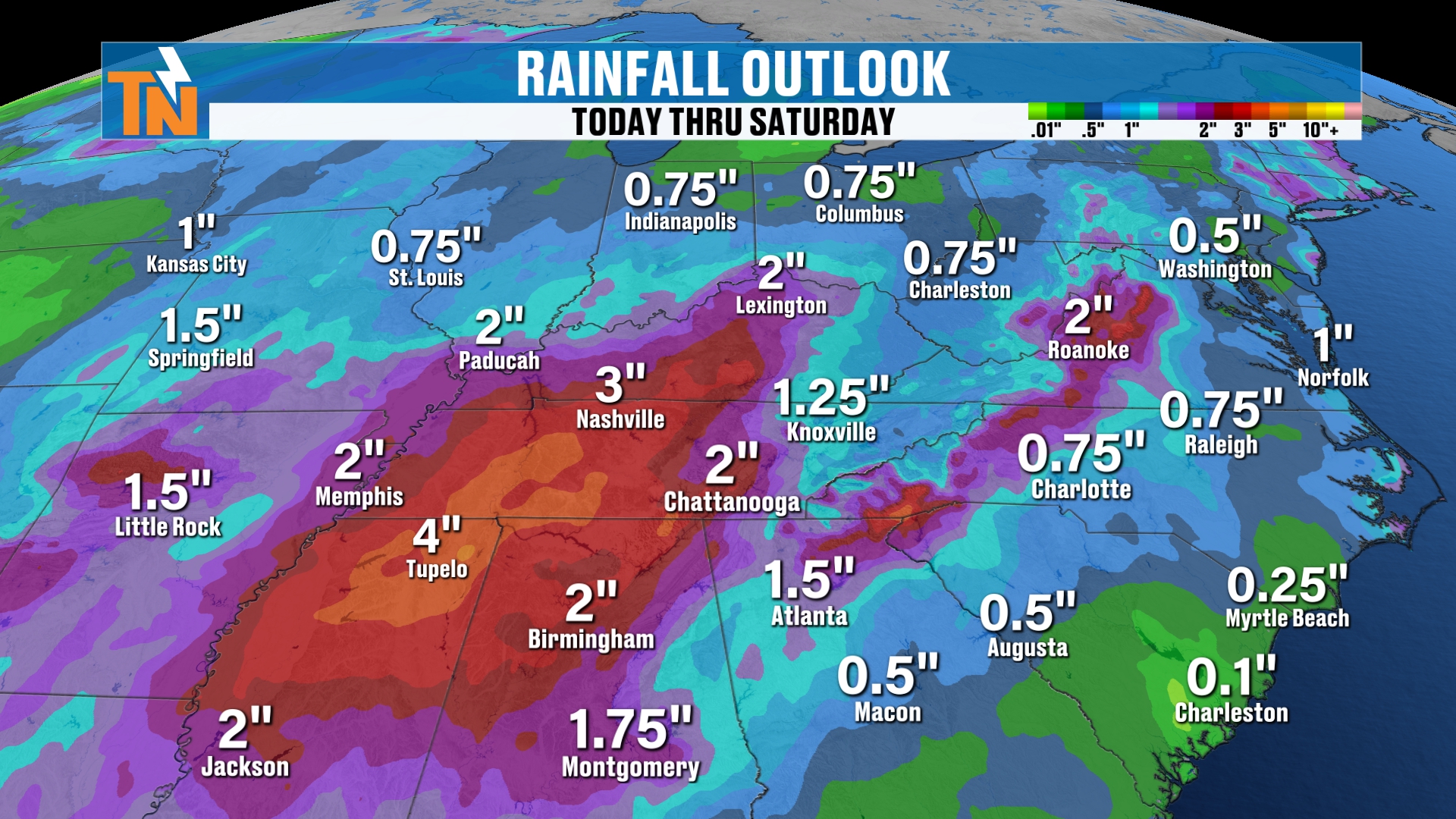
Now, the Weather Prediction Center is painting a picture of 3 to 4 inches across parts of Middle Tennessee down into northern Alabama.
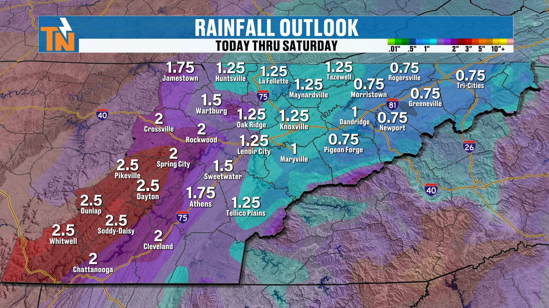
For us here locally, it’s 1 to 2 inches.
We will definitely see how this all plays out over the next couple of days. Make sure you check back in.
But it would be nice to get 1 to 2 inches of rainfall, because we desperately need it. We’re terribly dry.
Although, when you look at the entire month of October, we pretty much trended about average when it came to rainfall.
That’s due to the fact that we started the month with a lot of rain, and then we trended on the dry side.
Dew Points and Temperatures Through Next Week
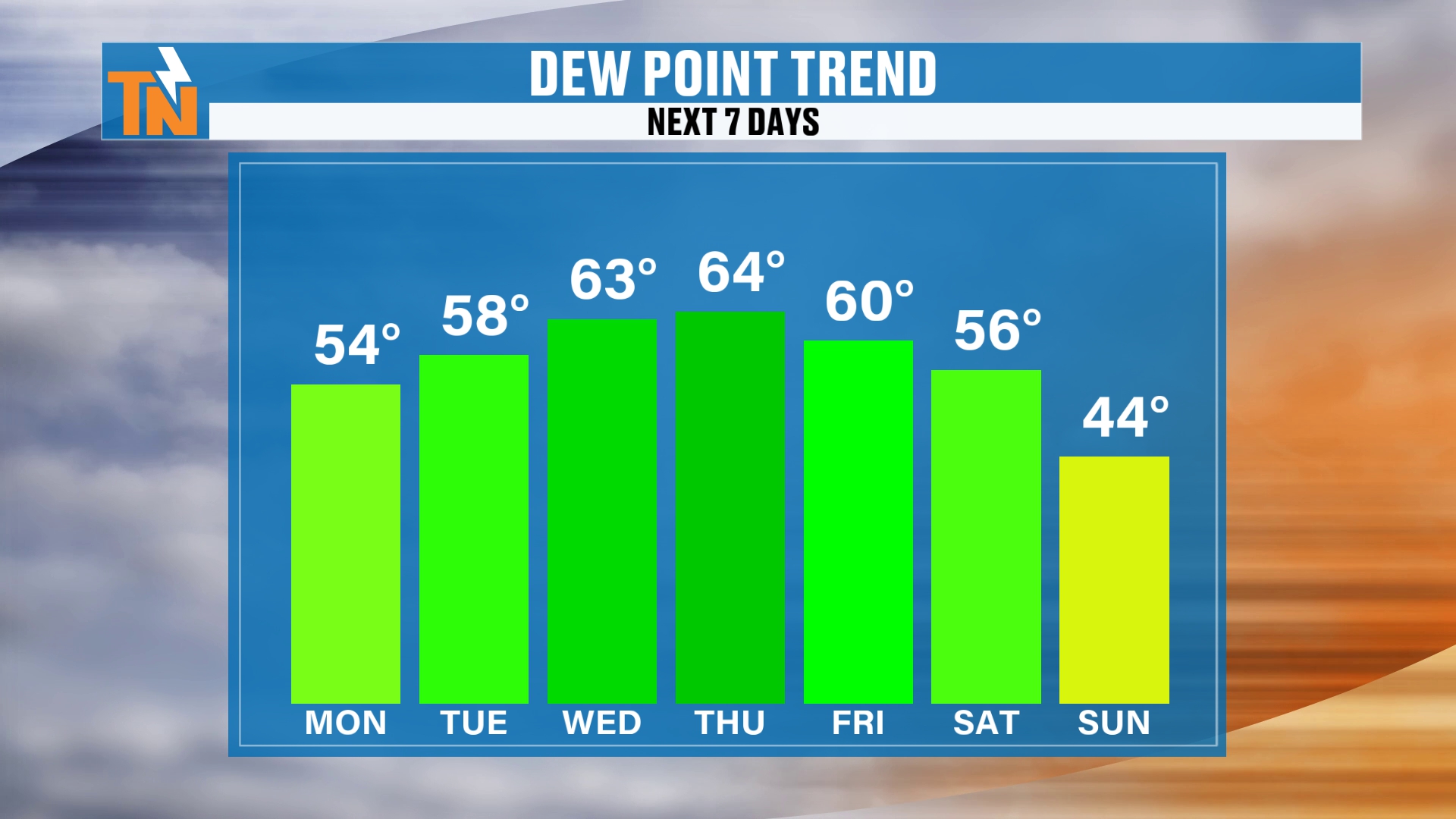
Back behind the system, the dew points will fall as we get into next Sunday.
That could potentially bring our forecast highs down into the low to mid 60s. So maybe even a little cooler than what we’re experiencing today, as we top out at 67.
Notice how the dew points climb to the low 60s on Wednesday and Thursday, ahead of and during the storm.
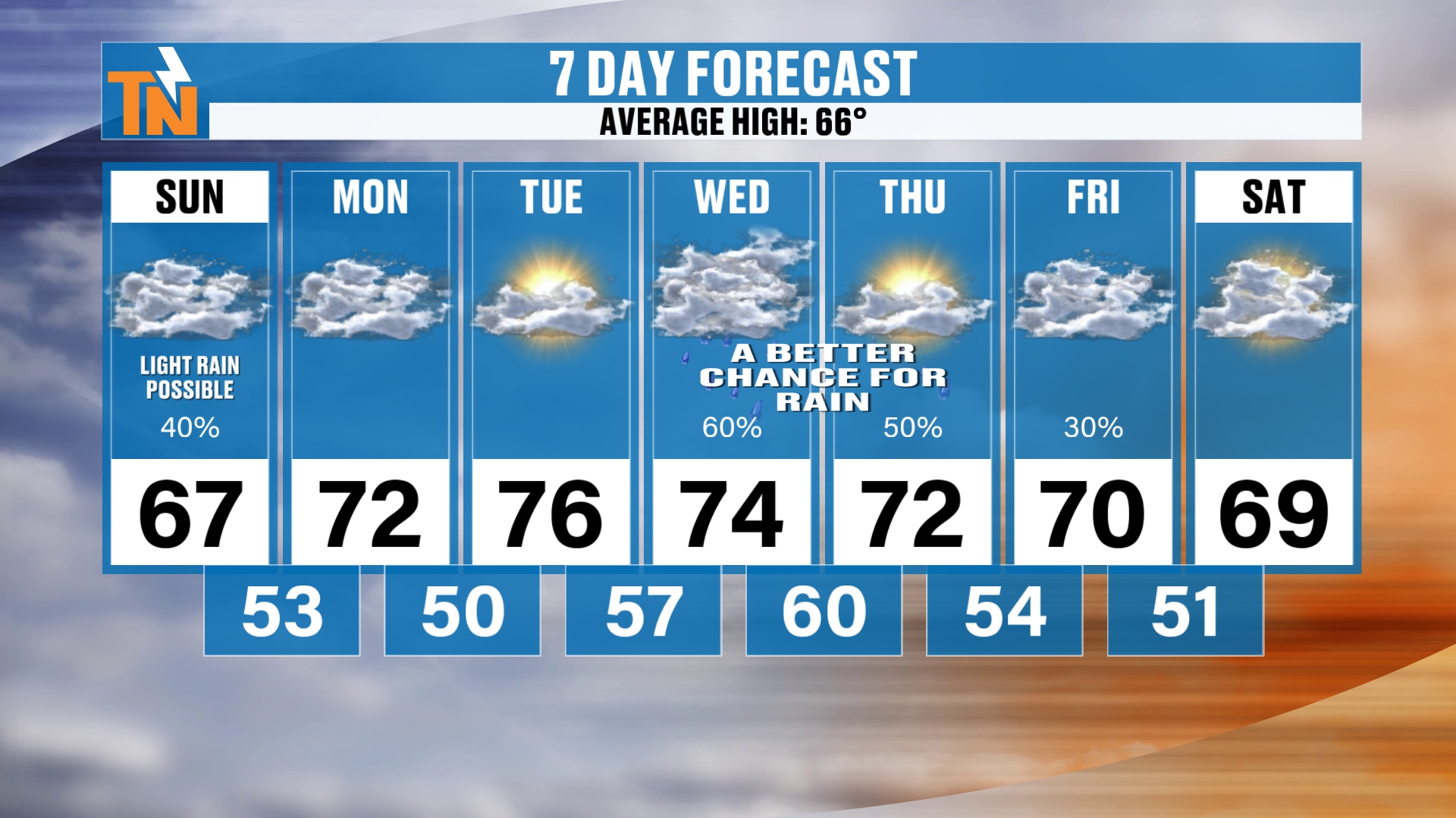
We’re back to the mid 70s by Tuesday, by the way. That’s the little ridge I talked about, the southerly flow out ahead of our storm system that comes through Wednesday and Thursday.
Right now I’m going with about a 50 to 60% chance of rain on Wednesday and Thursday.
Then behind it, temperatures will start to fall a little bit.
By Saturday we’re down to about 69° for a forecast high, and dew points will be lower.
So as we get into next Sunday and Monday, we’re going to be trending a little on the cooler side.
What the Climate Prediction Center Says
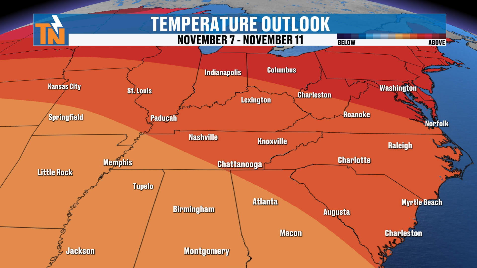
Let’s check in with the Climate Prediction Center.
Your 6 to 10 day outlook has us going above average.
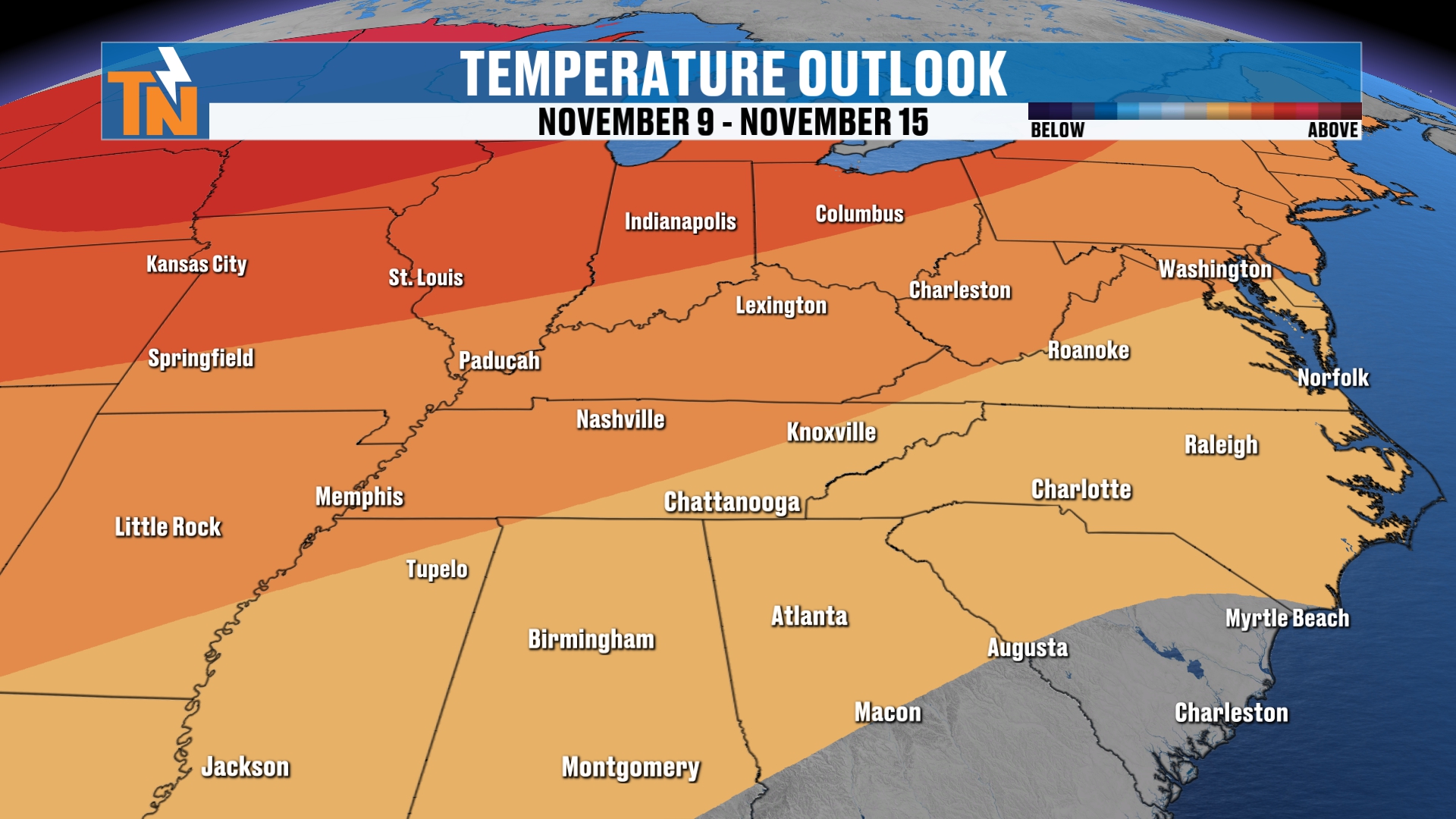
Your 8 to 14 day outlook still keeps us above average when it comes to temperatures.
Again, our average high for this time of year is in the mid to upper 60s. So anything above that is considered above average.
Bottom Line
SUNDAY: Rain is falling this morning, 40% chance. Mostly cloudy and mild, with light rain that weakens through the day. Highs in the mid to upper 60s (about 67 in Knoxville). 65 at 5 PM, 60 at 7 PM, 57 at 9 PM. Breezy across the highest peaks of the Smokies.
MONDAY: Dry. 0% chance of rain, with highs near 72.
TUESDAY: Dry and warmer. Mid 70s (about 76) ahead of the storm system.
WEDNESDAY: 60% chance of rain as the deep trough arrives and more moisture surges in.
THURSDAY: 50% chance of rain. Heavier rain, with 1 to 2 inches possible over the course of the storm.
FRIDAY: 30% chance of rain as the storm wraps up.
SATURDAY: Drier and a little cooler, with highs near 69.
NEXT SUNDAY AND MONDAY: Trending a little cooler as dew points fall behind the system.
Stay Weather Aware This November
Remember, November is our secondary severe weather season. So you need to pay attention, because storms will start to ramp up here through the month.
And as we get into the month of December, maybe we see some snow, thanks to our good old El Niño. An extremely strong El Niño.
Make sure you check in with the interactive radar using my East Tennessee Weather app.
Oh wait, a second. This is YouTube. You don’t have my East Tennessee Weather app, and you’re following me on YouTube.
Go to the app store, search East Tennessee Weather, and download the app. Look for the orange TN and the white lightning bolt.
If you allow location services and notifications, it works anywhere in the country.
Download the FREE eastTNweather app from your app store. It’s available on your phones, tablets and smart TVs, including Roku and Amazon Fire.
And if you’re watching on YouTube, don’t forget to LIKE, SHARE, SUBSCRIBE and hit the bell.
I appreciate you every single day. Let me know in the comments where you’re watching from. I always like to know.
Catch up on all of my recent daily forecasts anytime.
I’m Meteorologist Mike Witcher. Have a great Sunday!
eastTNweather — Weather When You Want It.