
Sunday Overview
Happy Sunday!
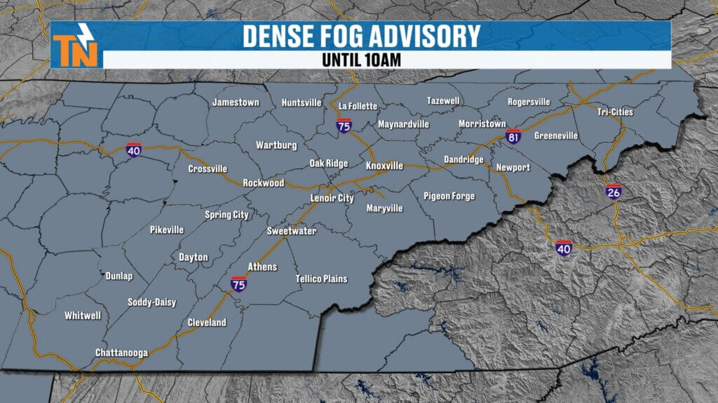
After yesterday’s rain, we’re waking up to some areas of dense fog this morning. That fog will burn off quickly, setting the stage for a beautiful day across East Tennessee.
Enjoy today, because the weather turns more active this week with increasing rain chances and even a risk for strong to severe thunderstorms.
Morning Fog and Early Conditions
- Areas of dense fog early this morning due to yesterday’s rainfall
- Temperatures starting in the 50s and 60s
- Visibility improves quickly after sunrise
Once the fog lifts, it’s smooth sailing for the rest of the day.
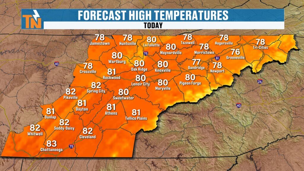
Sunday Forecast: Sunny, Warm, and Quiet
Today is the pick of the week:
- Mostly sunny skies
- Warm temperatures climbing into the 70s and 80s
- Dry and calm conditions
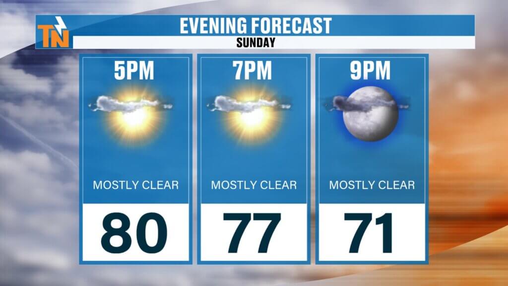
If you’ve got evening plans, it’s about as good as it gets:
Great weather for grilling or spending time outside
Around 78° by 7 PM
Pattern Change: Unsettled Weather Returns
The quiet weather doesn’t last long. As we head into the new week, a more active pattern takes over:
- Increasing moisture and instability
- Multiple waves of energy moving through
- Better chances for rain and thunderstorms
Rain chances ramp up starting Tuesday, remain elevated midweek, then briefly taper before another system approaches late week.
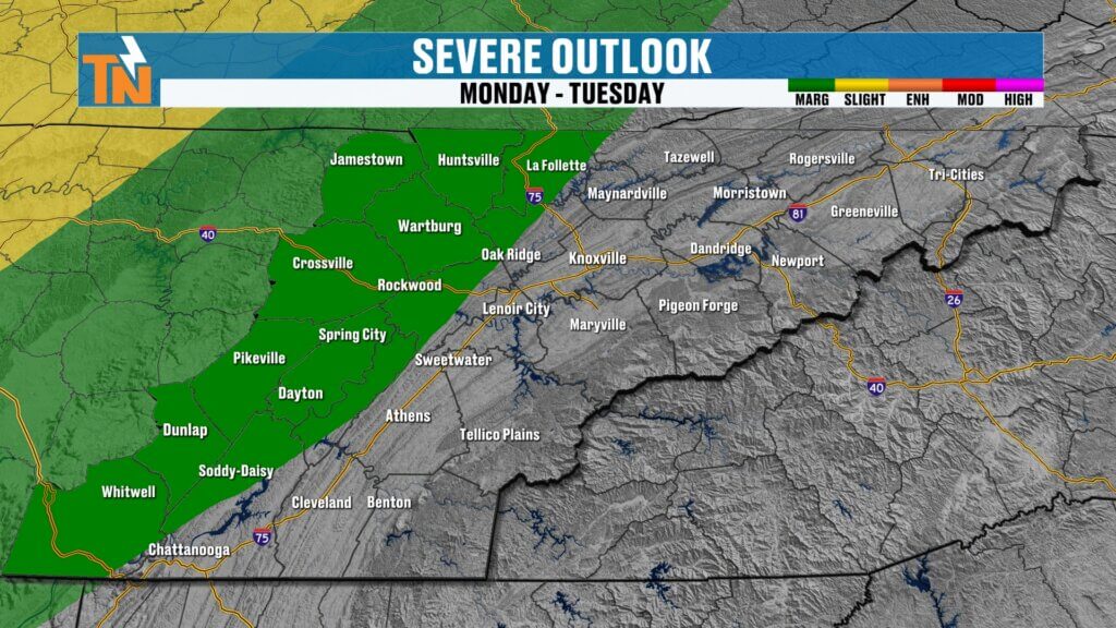
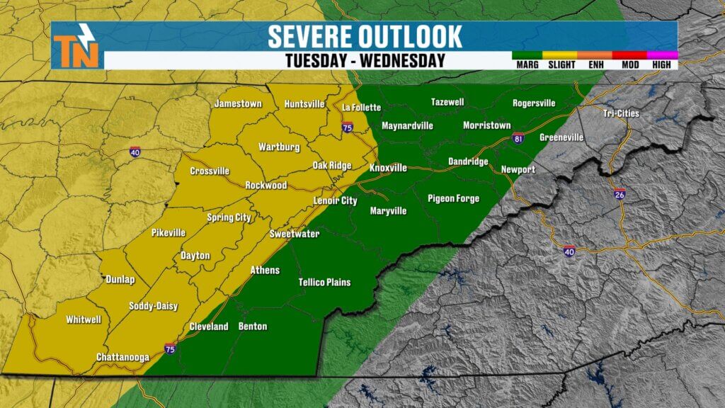
Severe Weather Risk This Week
We are watching the potential for strong to severe thunderstorms, especially:
- Monday into Tuesday
- Tuesday into Wednesday
The Storm Prediction Center has outlined risk areas that begin to edge into Tennessee early in the week.
Key timing:
- Late Monday night into early Tuesday morning: First round of storms
- Tuesday (midday into evening): Additional development possible
- Late Tuesday into Wednesday: Another wave bringing scattered storms
The early morning timing of Tuesday’s storms may help limit severity somewhat, but isolated strong storms are still possible.
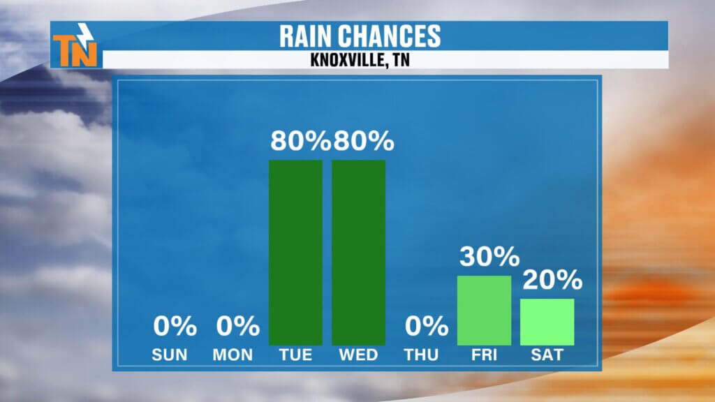
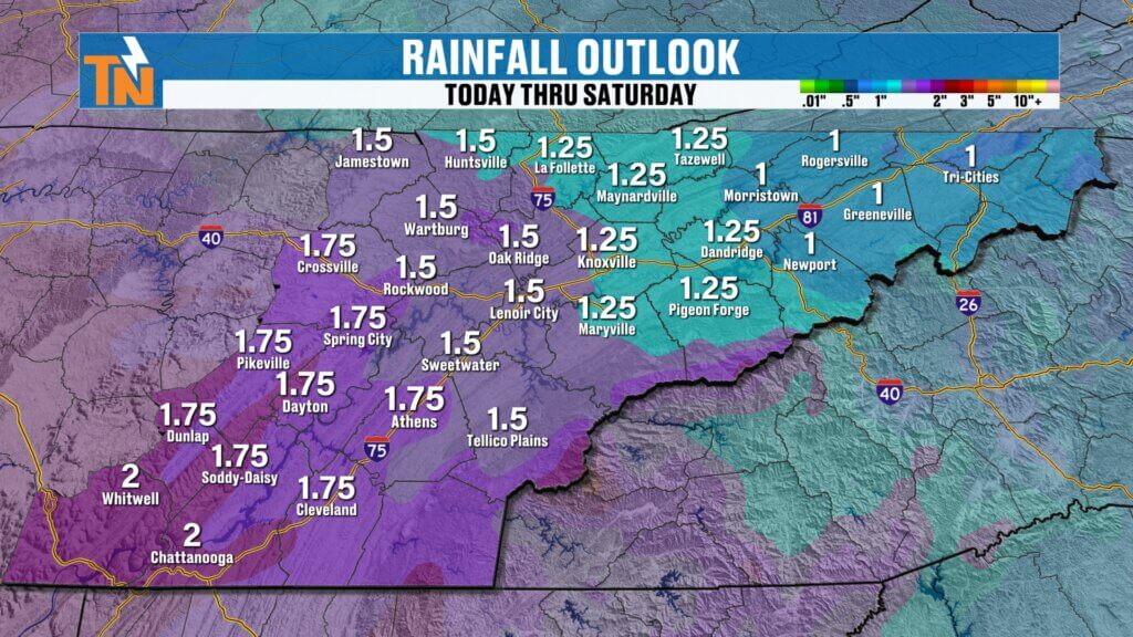
Rainfall Outlook
This week brings much-needed rainfall:
- Expected totals: 1 to 2 inches
- Locally higher amounts possible
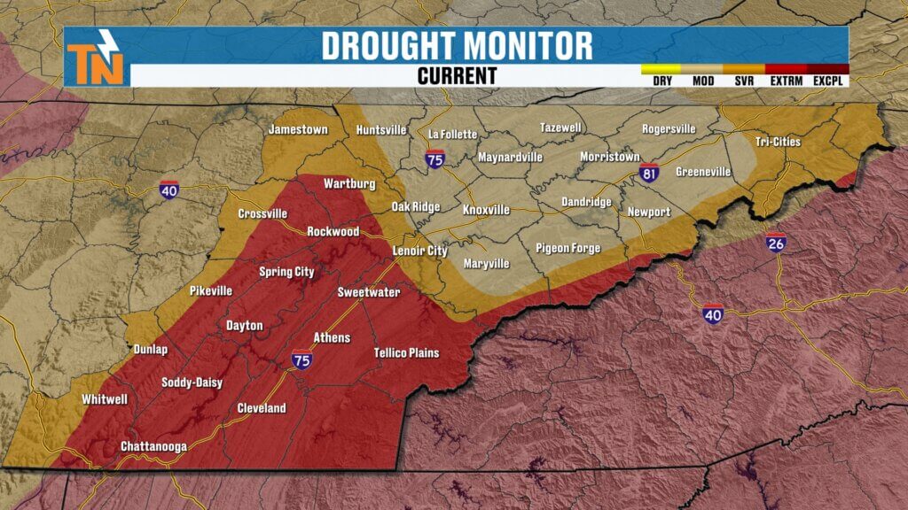
This is beneficial rain for ongoing drought conditions, even though it won’t immediately reflect in the current drought monitor.
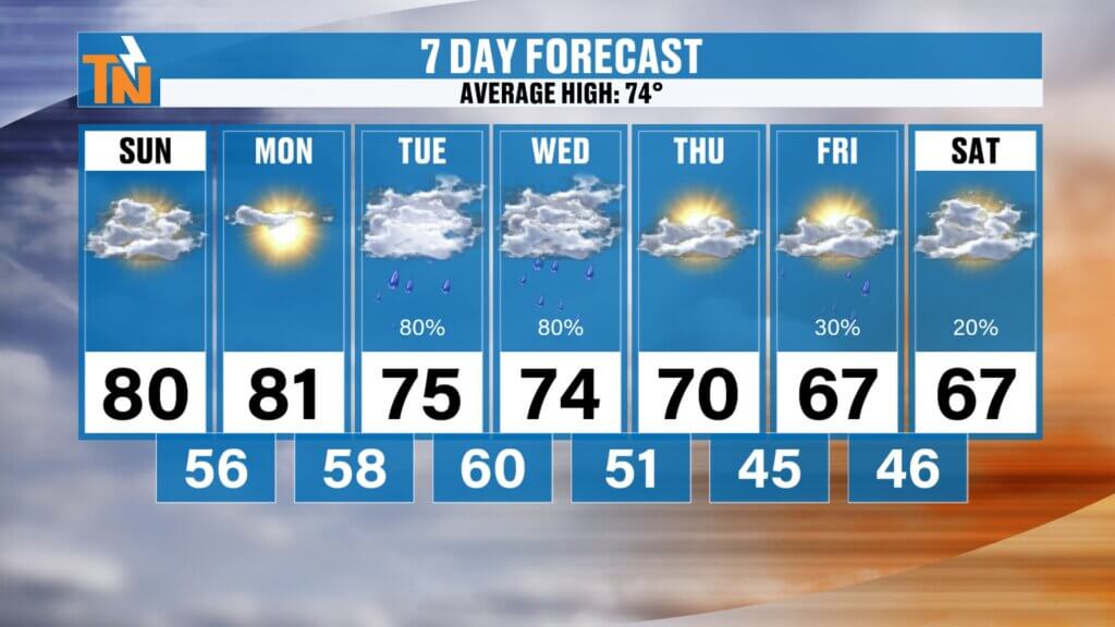
Temperature Trend
- Sunday and Monday: Above average, highs in the 80s
- Tuesday and Wednesday: Cooler, more seasonable with storms
- Late week into next weekend: Trending below average
A noticeable cooldown is expected as we head toward the first weekend of May.
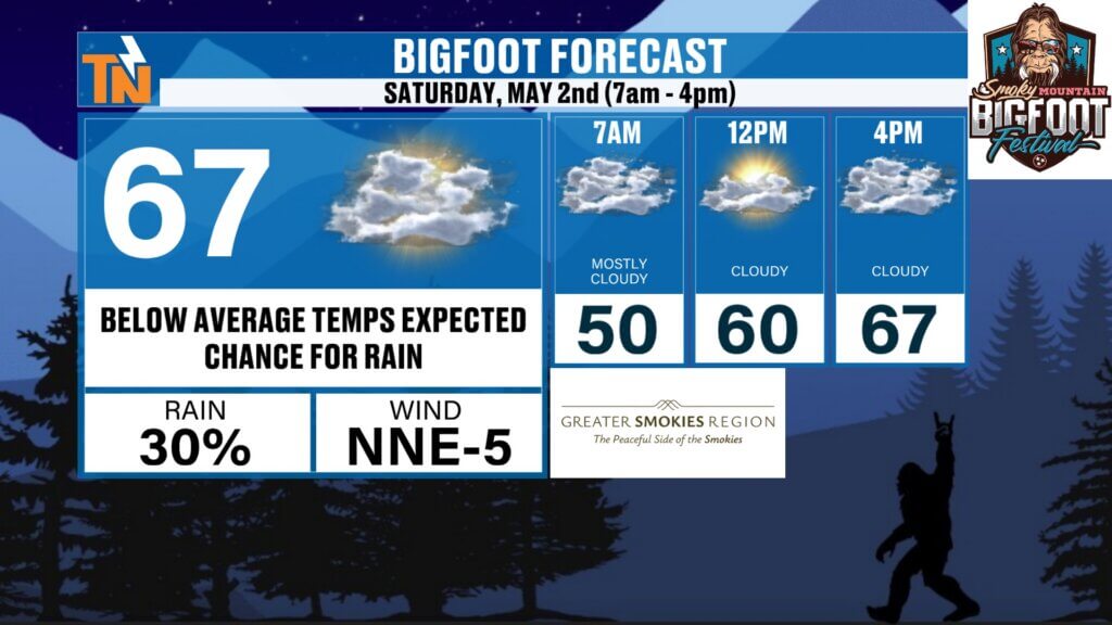
Bigfoot Festival Preview
Looking ahead to next weekend in Townsend:
- Bigfoot Festival: Saturday, 7 AM to 4 PM
- Early outlook: Cooler temperatures, likely in the low to mid 60s
- Rain chances still uncertain, but something to watch
Forecast details will be refined as we get closer.
What to Expect This Week
- Sunday: Sunny and warm
- Monday: Warm with increasing wind
- Tuesday–Wednesday: Storm chances with a risk for strong storms
- Late week: Cooler air moves in
- Next weekend: Potentially below-average temperatures
Final Thoughts
Today is a classic East Tennessee spring day—sunny, warm, and quiet. But the atmosphere is gearing up for a more active stretch with needed rainfall and a few storm chances.
Stay weather-aware this week, especially Tuesday and Wednesday, and keep checking in for updates.
Have a great Sunday! to check in with the East Tennessee weather app for the latest updates!