
Overview: Warm Pattern Before a Wet Shift
Good morning and happy Thursday! Thanks for checking in.
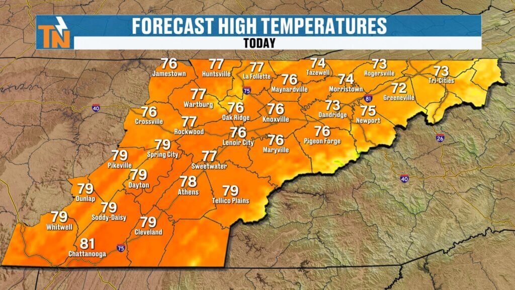
We’re coming off another warm day with highs in the 70s and 80s, and that trend continues into the end of the work week. High pressure remains anchored across the Southeast, keeping conditions warm, mostly dry, and slightly breezy.
But changes are coming. A cold front arrives this weekend, followed by additional systems early next week, bringing multiple chances for rain—and some much-needed moisture.

Thursday Forecast: Warm, Breezy, and Dry
We start the day with mild temperatures in the 40s and 50s.
- Afternoon highs: Upper 70s to low 80s
- Winds: Light to breezy at times
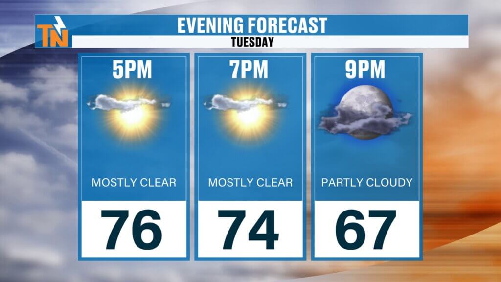
- Evening temps: Around 80° by 7 PM
Humidity will slowly increase, but overall conditions remain comfortable. Fire danger is still somewhat elevated, though recent moisture and rising humidity will help reduce that risk heading into the weekend.
Friday Outlook: Staying Warm and Quiet
Friday looks very similar:
- Highs in the low 80s
- Dry conditions continue
- Slightly breezier than Thursday
A great day to be outside before the weather turns more active.
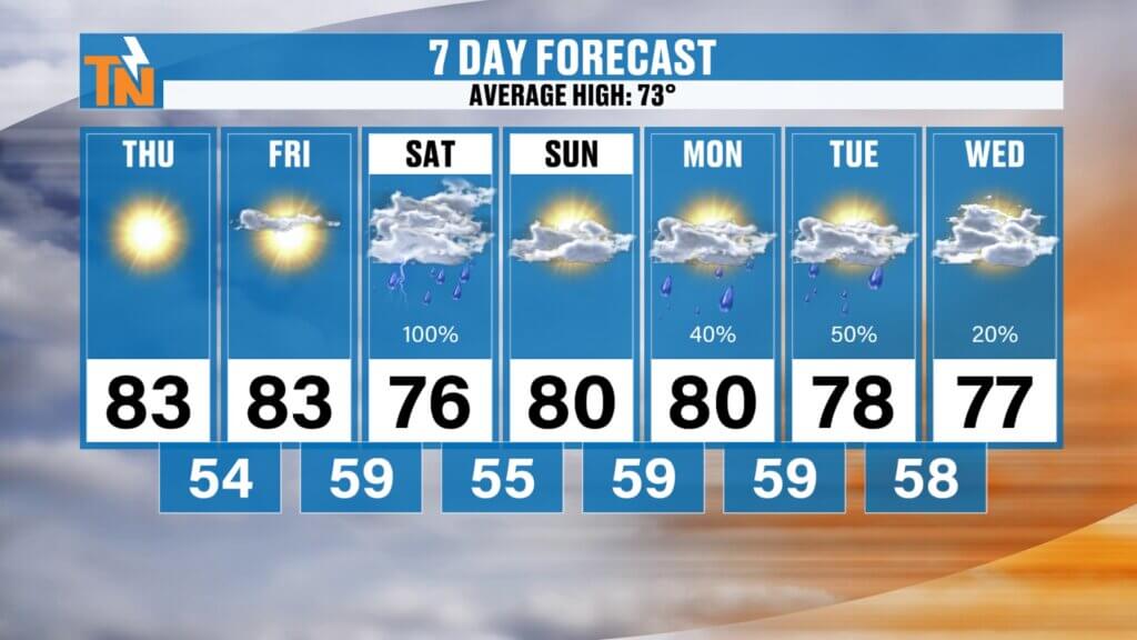
Saturday Forecast: Best Chance for Rain
Saturday is shaping up to be the wettest day in the near term.
- Rain likely develops around sunrise
- Steadiest rain expected through the afternoon (roughly sunrise to 4 PM)
- Showers gradually taper later in the day
This system should bring a solid round of beneficial rainfall across East Tennessee.
Sunday: Improving Conditions
After Saturday’s rain:
- Sunday looks drier overall
- Clouds decrease with warmer temperatures returning
- Highs back into the low 80s
A much better day compared to Saturday for outdoor plans.
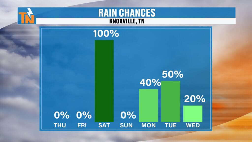
Early Next Week: More Rain and Storm Chances
The pattern stays active with additional systems moving in:
- Monday–Tuesday: Another round of showers and thunderstorms
- Potential for a few stronger storms
- Rain chances remain elevated into Wednesday and possibly Thursday
While the highest severe weather risk remains to our west initially, it may edge closer to East Tennessee early next week.
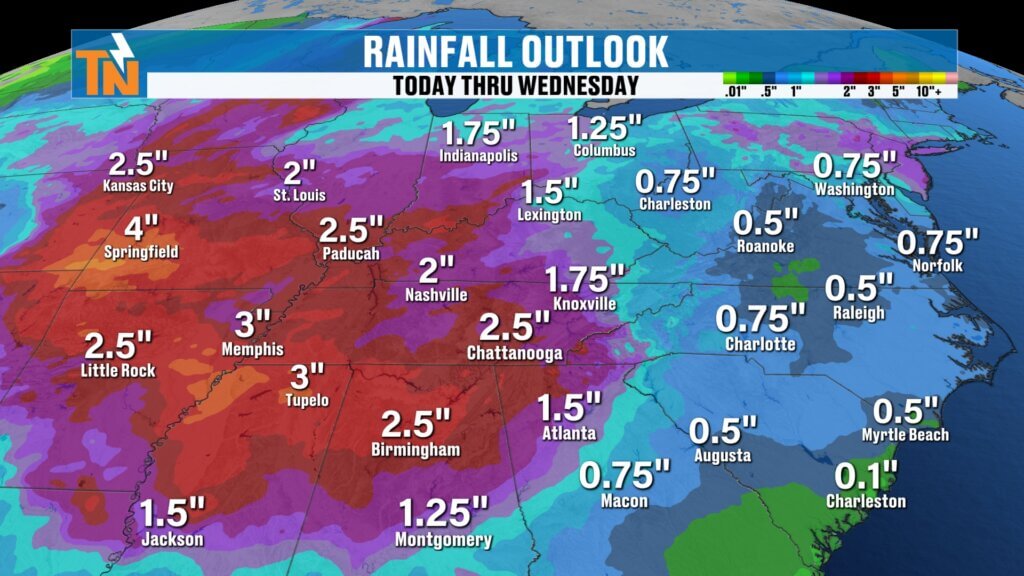
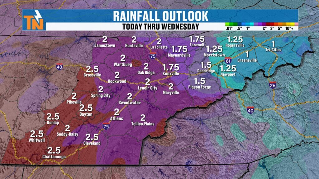
Rainfall Outlook: Much Needed Moisture
Over the next several days, rainfall totals could add up nicely:
- Through Wednesday: Around 1″ to 2″+ possible
- Some areas could approach 2.5″ depending on storm tracks
This would be very beneficial given ongoing dry conditions.
Temperature Trends
- Thursday–Friday: Low 80s (above average)
- Saturday: Mid 70s with rain
- Sunday–Monday: Back into the low 80s
- Tuesday–Wednesday: Upper 70s with rain chances
Average high this time of year is around 73°, so we’ll stay above normal overall.
Event Impact: Saturday Concerns
Saturday’s rain could impact several outdoor events across East Tennessee, including:
- Dogwood Arts Festival
- Zoofari at Zoo Knoxville
Daytime events are most likely to see steady rain, while evening conditions may improve somewhat—but timing could still shift.
Final Thoughts
Enjoy the warm and dry weather today and Friday. Saturday looks wet, followed by a brief break Sunday before more rain chances return early next week.
Forecast details—especially for Saturday—may still change, so check back for updates.
Have a great Thursday!